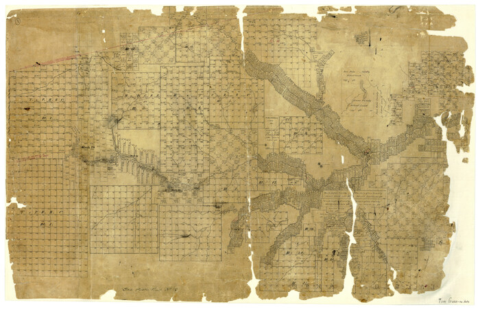
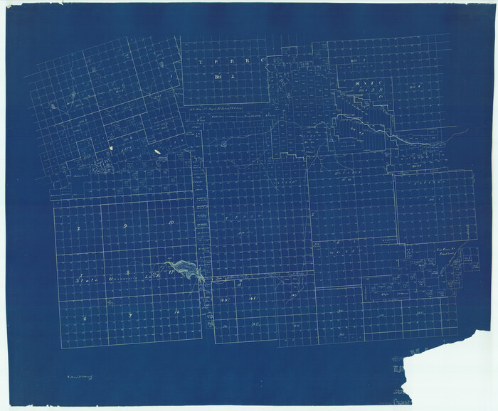
[Tom Green County]
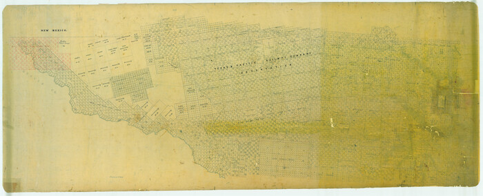
Print $40.00
- Digital $50.00
[Tom Green County]
1888
Size: 45.8 x 113.0 inches
82060
[Surveying Sketch in Tom Green County]
Print $3.00
- Digital $50.00
[Surveying Sketch in Tom Green County]
Size: 11.4 x 12.4 inches
75550
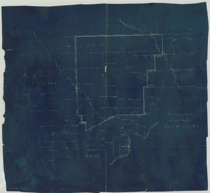
[Sketch in Reagan, Irion and Tom Green Counties]
Print $20.00
- Digital $50.00
[Sketch in Reagan, Irion and Tom Green Counties]
Size: 12.5 x 30.1 inches
75551
[Sketch Showing Surveys in Schleicher, Menard & Concho Counties, Texas]
Print $20.00
- Digital $50.00
[Sketch Showing Surveys in Schleicher, Menard & Concho Counties, Texas]
Size: 16.1 x 28.9 inches
75782
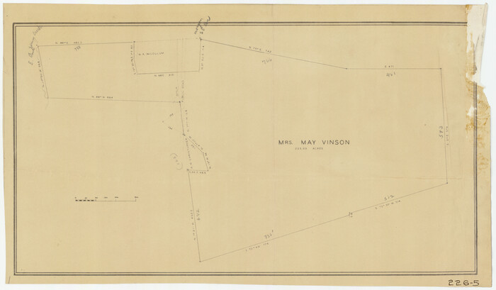
[Mrs. May Vinson Survey]
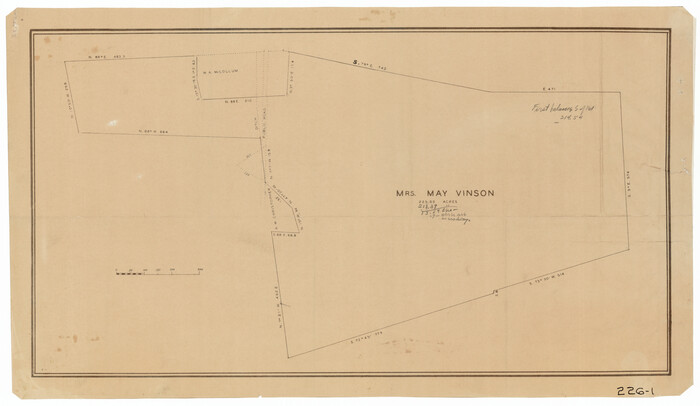
Print $20.00
- Digital $50.00
[Mrs. May Vinson Survey]
Size: 25.5 x 14.8 inches
91869
[Mrs. May Vinson Survey]
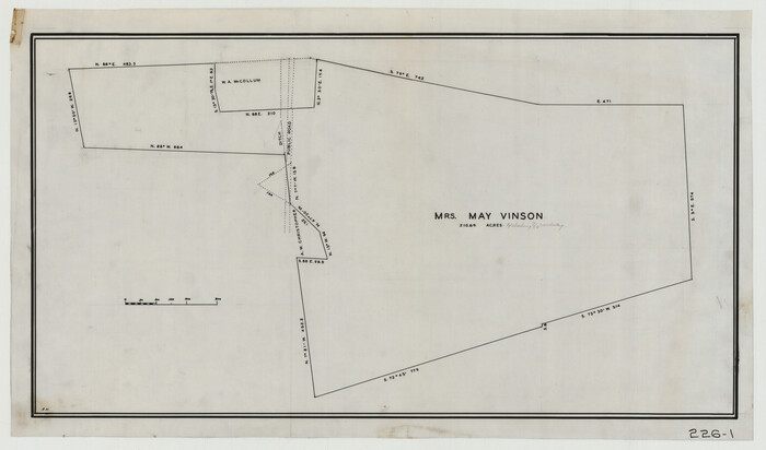
Print $20.00
- Digital $50.00
[Mrs. May Vinson Survey]
Size: 25.2 x 14.8 inches
91875
[Mrs. May Vinson Survey]
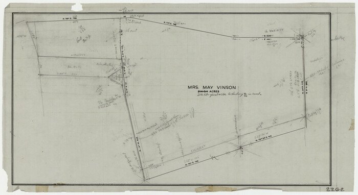
Print $20.00
- Digital $50.00
[Mrs. May Vinson Survey]
Size: 26.7 x 14.8 inches
91877
[Mrs. May Vinson Survey]
Print $20.00
- Digital $50.00
[Mrs. May Vinson Survey]
Size: 32.8 x 14.9 inches
91919
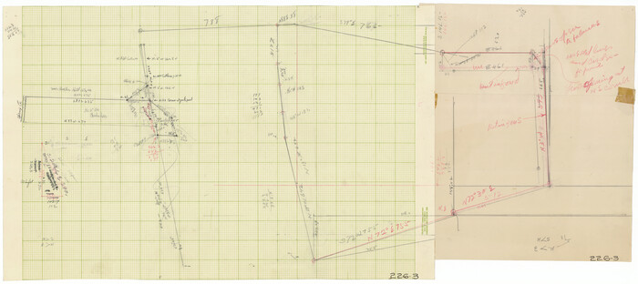
[Mrs. May Vinson Survey]
Print $20.00
- Digital $50.00
[Mrs. May Vinson Survey]
Size: 34.0 x 22.8 inches
91942
[Mrs. May Vinson Survey]
Print $20.00
- Digital $50.00
[Mrs. May Vinson Survey]
Size: 25.0 x 14.6 inches
91943
[Mrs. May Vinson Survey]
Print $40.00
- Digital $50.00
[Mrs. May Vinson Survey]
Size: 48.4 x 21.9 inches
91959
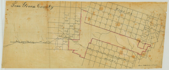
[Map of Tom Green County]
Print $20.00
- Digital $50.00
[Map of Tom Green County]
Size: 23.9 x 36.5 inches
4085
[Map of Tom Green County]
Print $40.00
- Digital $50.00
[Map of Tom Green County]
1933
Size: 50.0 x 60.6 inches
82061
Water-Shed of the Colorado River

Print $40.00
- Digital $50.00
Water-Shed of the Colorado River
1925
Size: 37.1 x 79.8 inches
65261
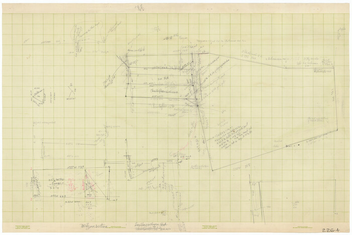
Water Valley Sheet, North Concho River, Tom Green County

Print $20.00
- Digital $50.00
Water Valley Sheet, North Concho River, Tom Green County
1937
Size: 23.6 x 19.1 inches
65305
Tom Green County Working Sketch Graphic Index

Print $40.00
- Digital $50.00
Tom Green County Working Sketch Graphic Index
1942
Size: 70.9 x 40.1 inches
76715
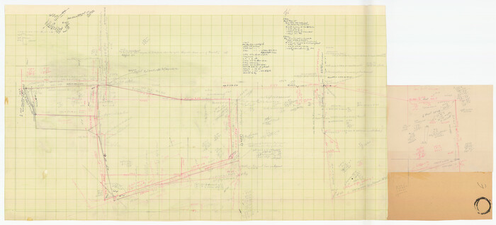
Tom Green County Working Sketch 9

Print $20.00
- Digital $50.00
Tom Green County Working Sketch 9
1951
Size: 31.3 x 42.2 inches
69378
Tom Green County Working Sketch 8

Print $20.00
- Digital $50.00
Tom Green County Working Sketch 8
1950
Size: 24.8 x 20.9 inches
69377
Tom Green County Working Sketch 7

Print $20.00
- Digital $50.00
Tom Green County Working Sketch 7
1949
Size: 32.2 x 31.7 inches
69376
Tom Green County Working Sketch 6

Print $40.00
- Digital $50.00
Tom Green County Working Sketch 6
1948
Size: 34.2 x 51.3 inches
69375
Tom Green County Working Sketch 5

Print $20.00
- Digital $50.00
Tom Green County Working Sketch 5
1948
Size: 34.0 x 40.3 inches
69374
Tom Green County Working Sketch 4

Print $20.00
- Digital $50.00
Tom Green County Working Sketch 4
1948
Size: 42.5 x 34.1 inches
69373
Tom Green County Working Sketch 3

Print $20.00
- Digital $50.00
Tom Green County Working Sketch 3
1933
Size: 47.5 x 40.2 inches
69372
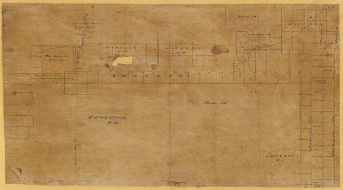
Tom Green County Working Sketch 2

Print $20.00
- Digital $50.00
Tom Green County Working Sketch 2
1917
Size: 21.1 x 32.9 inches
69371
Tom Green County Working Sketch 15

Print $20.00
- Digital $50.00
Tom Green County Working Sketch 15
1988
Size: 32.9 x 37.5 inches
69384
Tom Green County Working Sketch 14

Print $20.00
- Digital $50.00
Tom Green County Working Sketch 14
1982
Size: 32.7 x 22.7 inches
69383
Tom Green County Working Sketch 13

Print $20.00
- Digital $50.00
Tom Green County Working Sketch 13
1981
Size: 34.3 x 26.4 inches
69382
Tom Green County Working Sketch 12

Print $20.00
- Digital $50.00
Tom Green County Working Sketch 12
1975
Size: 30.0 x 41.1 inches
69381
Tom Green County Working Sketch 11

Print $20.00
- Digital $50.00
Tom Green County Working Sketch 11
1968
Size: 33.9 x 39.2 inches
69380
Tom Green County Working Sketch 10

Print $20.00
- Digital $50.00
Tom Green County Working Sketch 10
1959
Size: 22.0 x 32.7 inches
69379
[Tom Green County]
Print $40.00
- Digital $50.00
[Tom Green County]
1888
-
Size
45.8 x 113.0 inches
-
Map/Doc
82060
-
Creation Date
1888
[Surveying Sketch in Tom Green County]
Print $3.00
- Digital $50.00
[Surveying Sketch in Tom Green County]
-
Size
11.4 x 12.4 inches
-
Map/Doc
75550
[Sketch in Reagan, Irion and Tom Green Counties]
Print $20.00
- Digital $50.00
[Sketch in Reagan, Irion and Tom Green Counties]
-
Size
12.5 x 30.1 inches
-
Map/Doc
75551
[Sketch Showing Surveys in Schleicher, Menard & Concho Counties, Texas]
Print $20.00
- Digital $50.00
[Sketch Showing Surveys in Schleicher, Menard & Concho Counties, Texas]
-
Size
16.1 x 28.9 inches
-
Map/Doc
75782
[Mrs. May Vinson Survey]
Print $20.00
- Digital $50.00
[Mrs. May Vinson Survey]
-
Size
25.5 x 14.8 inches
-
Map/Doc
91869
[Mrs. May Vinson Survey]
Print $20.00
- Digital $50.00
[Mrs. May Vinson Survey]
-
Size
25.2 x 14.8 inches
-
Map/Doc
91875
[Mrs. May Vinson Survey]
Print $20.00
- Digital $50.00
[Mrs. May Vinson Survey]
-
Size
26.7 x 14.8 inches
-
Map/Doc
91877
[Mrs. May Vinson Survey]
Print $20.00
- Digital $50.00
[Mrs. May Vinson Survey]
-
Size
32.8 x 14.9 inches
-
Map/Doc
91919
[Mrs. May Vinson Survey]
Print $20.00
- Digital $50.00
[Mrs. May Vinson Survey]
-
Size
34.0 x 22.8 inches
-
Map/Doc
91942
[Mrs. May Vinson Survey]
Print $20.00
- Digital $50.00
[Mrs. May Vinson Survey]
-
Size
25.0 x 14.6 inches
-
Map/Doc
91943
[Mrs. May Vinson Survey]
Print $40.00
- Digital $50.00
[Mrs. May Vinson Survey]
-
Size
48.4 x 21.9 inches
-
Map/Doc
91959
[Map of Tom Green County]
Print $20.00
- Digital $50.00
[Map of Tom Green County]
-
Size
23.9 x 36.5 inches
-
Map/Doc
4085
[Map of Tom Green County]
Print $40.00
- Digital $50.00
[Map of Tom Green County]
1933
-
Size
50.0 x 60.6 inches
-
Map/Doc
82061
-
Creation Date
1933
Water-Shed of the Colorado River
Print $40.00
- Digital $50.00
Water-Shed of the Colorado River
1925
-
Size
37.1 x 79.8 inches
-
Map/Doc
65261
-
Creation Date
1925
Water Valley Sheet, North Concho River, Tom Green County
Print $20.00
- Digital $50.00
Water Valley Sheet, North Concho River, Tom Green County
1937
-
Size
23.6 x 19.1 inches
-
Map/Doc
65305
-
Creation Date
1937
Tom Green County Working Sketch Graphic Index
Print $40.00
- Digital $50.00
Tom Green County Working Sketch Graphic Index
1942
-
Size
70.9 x 40.1 inches
-
Map/Doc
76715
-
Creation Date
1942
Tom Green County Working Sketch 9
Print $20.00
- Digital $50.00
Tom Green County Working Sketch 9
1951
-
Size
31.3 x 42.2 inches
-
Map/Doc
69378
-
Creation Date
1951
Tom Green County Working Sketch 8
Print $20.00
- Digital $50.00
Tom Green County Working Sketch 8
1950
-
Size
24.8 x 20.9 inches
-
Map/Doc
69377
-
Creation Date
1950
Tom Green County Working Sketch 7
Print $20.00
- Digital $50.00
Tom Green County Working Sketch 7
1949
-
Size
32.2 x 31.7 inches
-
Map/Doc
69376
-
Creation Date
1949
Tom Green County Working Sketch 6
Print $40.00
- Digital $50.00
Tom Green County Working Sketch 6
1948
-
Size
34.2 x 51.3 inches
-
Map/Doc
69375
-
Creation Date
1948
Tom Green County Working Sketch 5
Print $20.00
- Digital $50.00
Tom Green County Working Sketch 5
1948
-
Size
34.0 x 40.3 inches
-
Map/Doc
69374
-
Creation Date
1948
Tom Green County Working Sketch 4
Print $20.00
- Digital $50.00
Tom Green County Working Sketch 4
1948
-
Size
42.5 x 34.1 inches
-
Map/Doc
69373
-
Creation Date
1948
Tom Green County Working Sketch 3
Print $20.00
- Digital $50.00
Tom Green County Working Sketch 3
1933
-
Size
47.5 x 40.2 inches
-
Map/Doc
69372
-
Creation Date
1933
Tom Green County Working Sketch 2
Print $20.00
- Digital $50.00
Tom Green County Working Sketch 2
1917
-
Size
21.1 x 32.9 inches
-
Map/Doc
69371
-
Creation Date
1917
Tom Green County Working Sketch 15
Print $20.00
- Digital $50.00
Tom Green County Working Sketch 15
1988
-
Size
32.9 x 37.5 inches
-
Map/Doc
69384
-
Creation Date
1988
Tom Green County Working Sketch 14
Print $20.00
- Digital $50.00
Tom Green County Working Sketch 14
1982
-
Size
32.7 x 22.7 inches
-
Map/Doc
69383
-
Creation Date
1982
Tom Green County Working Sketch 13
Print $20.00
- Digital $50.00
Tom Green County Working Sketch 13
1981
-
Size
34.3 x 26.4 inches
-
Map/Doc
69382
-
Creation Date
1981
Tom Green County Working Sketch 12
Print $20.00
- Digital $50.00
Tom Green County Working Sketch 12
1975
-
Size
30.0 x 41.1 inches
-
Map/Doc
69381
-
Creation Date
1975
Tom Green County Working Sketch 11
Print $20.00
- Digital $50.00
Tom Green County Working Sketch 11
1968
-
Size
33.9 x 39.2 inches
-
Map/Doc
69380
-
Creation Date
1968
Tom Green County Working Sketch 10
Print $20.00
- Digital $50.00
Tom Green County Working Sketch 10
1959
-
Size
22.0 x 32.7 inches
-
Map/Doc
69379
-
Creation Date
1959