Victoria County Rolled Sketch 4A

Print $40.00
- Digital $50.00
Victoria County Rolled Sketch 4A
Size: 66.4 x 43.9 inches
10095
Duval County Sketch File 35

Print $24.00
- Digital $50.00
Duval County Sketch File 35
Size: 14.4 x 8.8 inches
21359
Victoria County Sketch File 5a

Print $2.00
- Digital $50.00
Victoria County Sketch File 5a
Size: 8.2 x 12.9 inches
39522
Victoria County Sketch File 6

Print $2.00
- Digital $50.00
Victoria County Sketch File 6
Size: 5.3 x 12.5 inches
39523
Victoria County Sketch File 8

Print $2.00
- Digital $50.00
Victoria County Sketch File 8
Size: 5.7 x 5.6 inches
39524
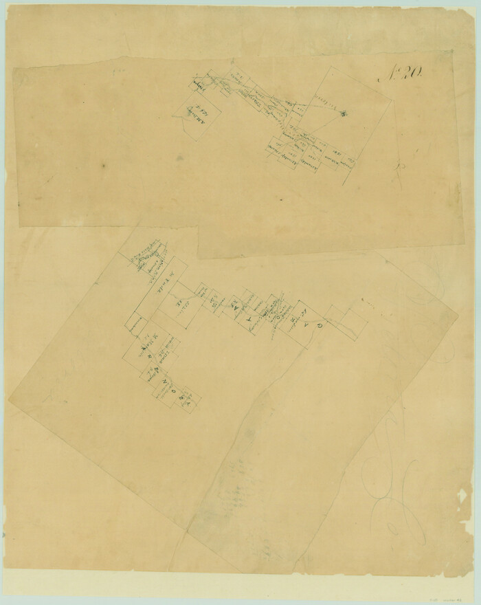
Victoria County Boundary File 91

Print $12.00
- Digital $50.00
Victoria County Boundary File 91
Size: 8.9 x 6.5 inches
59620
Right of Way and Track Map, Galveston, Harrisburg & San Antonio Ry. operated by the T. & N. O. R.R. Co., Victoria Division, Rosenberg to Beeville

Print $40.00
- Digital $50.00
Right of Way and Track Map, Galveston, Harrisburg & San Antonio Ry. operated by the T. & N. O. R.R. Co., Victoria Division, Rosenberg to Beeville
Size: 24.3 x 55.8 inches
76162
Southern Pacific Transportation Company, Right of Way and Track Map, Beeville Branch

Print $40.00
- Digital $50.00
Southern Pacific Transportation Company, Right of Way and Track Map, Beeville Branch
Size: 24.1 x 56.1 inches
76163
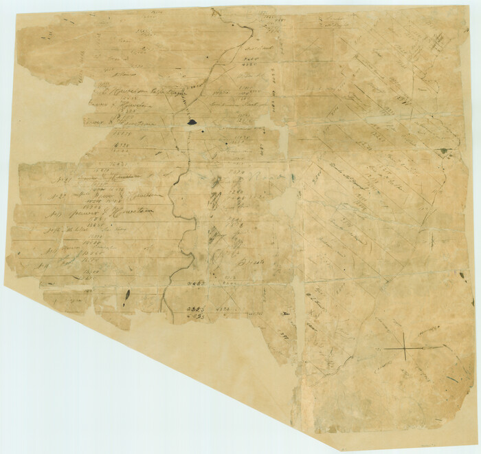
Victoria County Rolled Sketch 6

Print $20.00
- Digital $50.00
Victoria County Rolled Sketch 6
Size: 27.9 x 36.3 inches
8152
Victoria County Rolled Sketch 8

Print $20.00
- Digital $50.00
Victoria County Rolled Sketch 8
Size: 34.2 x 27.5 inches
8153
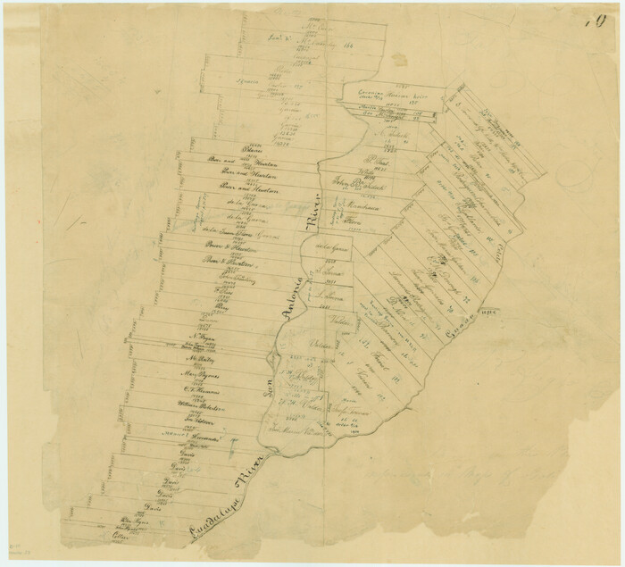
Victoria County Rolled Sketch 9

Print $20.00
- Digital $50.00
Victoria County Rolled Sketch 9
Size: 24.1 x 36.2 inches
95399
Victoria County Rolled Sketch 9

Print $20.00
- Digital $50.00
Victoria County Rolled Sketch 9
Size: 24.1 x 36.1 inches
95400
Guadalupe-Blanco River Authority Master Plan

Print $20.00
Guadalupe-Blanco River Authority Master Plan
Size: 23.1 x 29.8 inches
97506
[Surveys in DeLeon's Colony along the Garcitas River and Arenosa Creek, including the Victoria town tract]
Print $20.00
- Digital $50.00
[Surveys in DeLeon's Colony along the Garcitas River and Arenosa Creek, including the Victoria town tract]
1824
Size: 22.1 x 17.6 inches
42
[Surveys in Power and Hewetson's Colony]
Print $20.00
- Digital $50.00
[Surveys in Power and Hewetson's Colony]
1830
Size: 21.3 x 22.5 inches
2
Connected Map of DeWitt's Colony compiled from the surveys of Byrd Lockhart

Print $40.00
- Digital $50.00
Connected Map of DeWitt's Colony compiled from the surveys of Byrd Lockhart
1831
Size: 39.2 x 54.0 inches
1942
[Surveys in Power and Hewetson's Colony along the San Antonio and Guadalupe Rivers]
Print $20.00
- Digital $50.00
[Surveys in Power and Hewetson's Colony along the San Antonio and Guadalupe Rivers]
1837
Size: 14.9 x 16.5 inches
23
Connected Map of the County of Victoria

Print $40.00
- Digital $50.00
Connected Map of the County of Victoria
1838
Size: 79.7 x 49.0 inches
1946
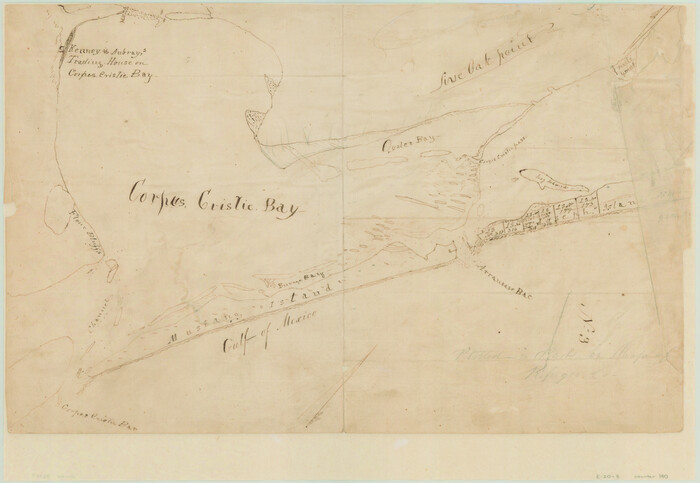
[Aransas and Corpus Christi Bays]
Print $3.00
- Digital $50.00
[Aransas and Corpus Christi Bays]
1839
Size: 11.4 x 16.5 inches
140
A Map of Matagorda Bay and County With the Adjacent County

Print $20.00
- Digital $50.00
A Map of Matagorda Bay and County With the Adjacent County
1839
Size: 33.9 x 43.1 inches
4855
[Surveys between the Lavaca River and Arenosa Creek]
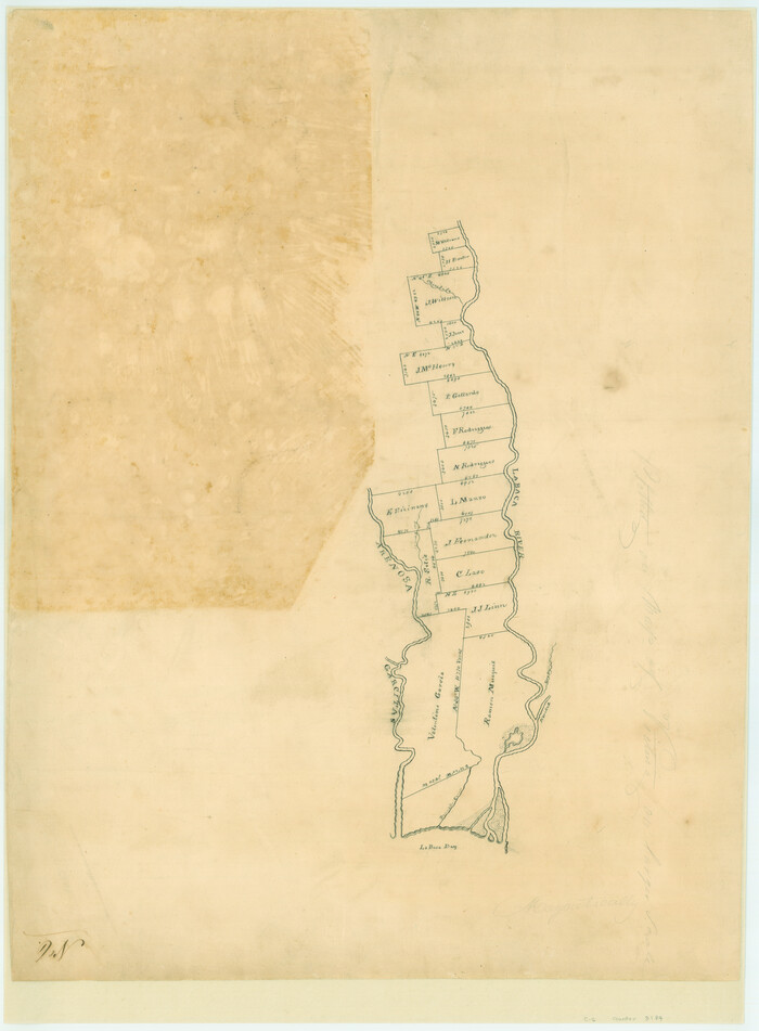
Print $20.00
- Digital $50.00
[Surveys between the Lavaca River and Arenosa Creek]
1840
Size: 25.6 x 18.9 inches
3184
Lavaca County Sketch File 2

Print $6.00
- Digital $50.00
Lavaca County Sketch File 2
1849
Size: 8.7 x 7.5 inches
29630
[Plat of Victoria, Texas]
Print $20.00
[Plat of Victoria, Texas]
1850
Size: 14.1 x 11.5 inches
76270
Lavaca County Sketch File 3

Print $8.00
- Digital $50.00
Lavaca County Sketch File 3
1853
Size: 10.1 x 9.8 inches
29633
Victoria County Sketch File 1

Print $20.00
- Digital $50.00
Victoria County Sketch File 1
1853
Size: 12.9 x 17.3 inches
12595
Topographical Map of the country between San Antonio & Colorado Rivers in the State of Texas.

Print $40.00
Topographical Map of the country between San Antonio & Colorado Rivers in the State of Texas.
1864
Size: 53.3 x 69.2 inches
88604
Topographical Map of the country between San Antonio & Colorado Rivers in the State of Texas.

Print $40.00
Topographical Map of the country between San Antonio & Colorado Rivers in the State of Texas.
1864
Size: 53.2 x 74.8 inches
88606
Victoria County Rolled Sketch 4A
Print $40.00
- Digital $50.00
Victoria County Rolled Sketch 4A
-
Size
66.4 x 43.9 inches
-
Map/Doc
10095
[Victoria District]
![1945, [Victoria District], General Map Collection](https://historictexasmaps.com/wmedia_w700/maps/1945.tif.jpg)
Print $20.00
- Digital $50.00
[Victoria District]
-
Size
34.8 x 25.6 inches
-
Map/Doc
1945
Duval County Sketch File 35
Print $24.00
- Digital $50.00
Duval County Sketch File 35
-
Size
14.4 x 8.8 inches
-
Map/Doc
21359
Victoria County Sketch File 5a
Print $2.00
- Digital $50.00
Victoria County Sketch File 5a
-
Size
8.2 x 12.9 inches
-
Map/Doc
39522
Victoria County Sketch File 6
Print $2.00
- Digital $50.00
Victoria County Sketch File 6
-
Size
5.3 x 12.5 inches
-
Map/Doc
39523
Victoria County Sketch File 8
Print $2.00
- Digital $50.00
Victoria County Sketch File 8
-
Size
5.7 x 5.6 inches
-
Map/Doc
39524
Victoria County Boundary File 91
Print $12.00
- Digital $50.00
Victoria County Boundary File 91
-
Size
8.9 x 6.5 inches
-
Map/Doc
59620
Right of Way and Track Map, Galveston, Harrisburg & San Antonio Ry. operated by the T. & N. O. R.R. Co., Victoria Division, Rosenberg to Beeville
Print $40.00
- Digital $50.00
Right of Way and Track Map, Galveston, Harrisburg & San Antonio Ry. operated by the T. & N. O. R.R. Co., Victoria Division, Rosenberg to Beeville
-
Size
24.3 x 55.8 inches
-
Map/Doc
76162
Southern Pacific Transportation Company, Right of Way and Track Map, Beeville Branch
Print $40.00
- Digital $50.00
Southern Pacific Transportation Company, Right of Way and Track Map, Beeville Branch
-
Size
24.1 x 56.1 inches
-
Map/Doc
76163
Victoria County Rolled Sketch 6
Print $20.00
- Digital $50.00
Victoria County Rolled Sketch 6
-
Size
27.9 x 36.3 inches
-
Map/Doc
8152
Victoria County Rolled Sketch 8
Print $20.00
- Digital $50.00
Victoria County Rolled Sketch 8
-
Size
34.2 x 27.5 inches
-
Map/Doc
8153
Victoria County Rolled Sketch 9
Print $20.00
- Digital $50.00
Victoria County Rolled Sketch 9
-
Size
24.1 x 36.2 inches
-
Map/Doc
95399
Victoria County Rolled Sketch 9
Print $20.00
- Digital $50.00
Victoria County Rolled Sketch 9
-
Size
24.1 x 36.1 inches
-
Map/Doc
95400
Guadalupe-Blanco River Authority Master Plan
Print $20.00
Guadalupe-Blanco River Authority Master Plan
-
Size
23.1 x 29.8 inches
-
Map/Doc
97506
[Surveys in DeLeon's Colony along the Garcitas River and Arenosa Creek, including the Victoria town tract]
Print $20.00
- Digital $50.00
[Surveys in DeLeon's Colony along the Garcitas River and Arenosa Creek, including the Victoria town tract]
1824
-
Size
22.1 x 17.6 inches
-
Map/Doc
42
-
Creation Date
1824
[Surveys in Power and Hewetson's Colony]
Print $20.00
- Digital $50.00
[Surveys in Power and Hewetson's Colony]
1830
-
Size
21.3 x 22.5 inches
-
Map/Doc
2
-
Creation Date
1830
Connected Map of DeWitt's Colony compiled from the surveys of Byrd Lockhart
Print $40.00
- Digital $50.00
Connected Map of DeWitt's Colony compiled from the surveys of Byrd Lockhart
1831
-
Size
39.2 x 54.0 inches
-
Map/Doc
1942
-
Creation Date
1831
[Surveys in Power and Hewetson's Colony along the San Antonio and Guadalupe Rivers]
Print $20.00
- Digital $50.00
[Surveys in Power and Hewetson's Colony along the San Antonio and Guadalupe Rivers]
1837
-
Size
14.9 x 16.5 inches
-
Map/Doc
23
-
Creation Date
1837
Connected Map of the County of Victoria
Print $40.00
- Digital $50.00
Connected Map of the County of Victoria
1838
-
Size
79.7 x 49.0 inches
-
Map/Doc
1946
-
Creation Date
1838
[Aransas and Corpus Christi Bays]
Print $3.00
- Digital $50.00
[Aransas and Corpus Christi Bays]
1839
-
Size
11.4 x 16.5 inches
-
Map/Doc
140
-
Creation Date
1839
A Map of Matagorda Bay and County With the Adjacent County
Print $20.00
- Digital $50.00
A Map of Matagorda Bay and County With the Adjacent County
1839
-
Size
33.9 x 43.1 inches
-
Map/Doc
4855
-
Creation Date
1839
[Surveys between the Lavaca River and Arenosa Creek]
Print $20.00
- Digital $50.00
[Surveys between the Lavaca River and Arenosa Creek]
1840
-
Size
25.6 x 18.9 inches
-
Map/Doc
3184
-
Creation Date
1840
Lavaca County Sketch File 2
Print $6.00
- Digital $50.00
Lavaca County Sketch File 2
1849
-
Size
8.7 x 7.5 inches
-
Map/Doc
29630
-
Creation Date
1849
[Plat of Victoria, Texas]
Print $20.00
[Plat of Victoria, Texas]
1850
-
Size
14.1 x 11.5 inches
-
Map/Doc
76270
-
Creation Date
1850
Lavaca County Sketch File 3
Print $8.00
- Digital $50.00
Lavaca County Sketch File 3
1853
-
Size
10.1 x 9.8 inches
-
Map/Doc
29633
-
Creation Date
1853
Victoria County Sketch File 1
Print $20.00
- Digital $50.00
Victoria County Sketch File 1
1853
-
Size
12.9 x 17.3 inches
-
Map/Doc
12595
-
Creation Date
1853
Refugio District

Print $20.00
- Digital $50.00
Refugio District
1855
-
Size
30.7 x 34.7 inches
-
Map/Doc
2139
-
Creation Date
1855
Victoria County

Print $20.00
- Digital $50.00
Victoria County
1858
-
Size
26.5 x 29.2 inches
-
Map/Doc
4115
-
Creation Date
1858
Topographical Map of the country between San Antonio & Colorado Rivers in the State of Texas.
Print $40.00
Topographical Map of the country between San Antonio & Colorado Rivers in the State of Texas.
1864
-
Size
53.3 x 69.2 inches
-
Map/Doc
88604
-
Creation Date
1864
Topographical Map of the country between San Antonio & Colorado Rivers in the State of Texas.
Print $40.00
Topographical Map of the country between San Antonio & Colorado Rivers in the State of Texas.
1864
-
Size
53.2 x 74.8 inches
-
Map/Doc
88606
-
Creation Date
1864