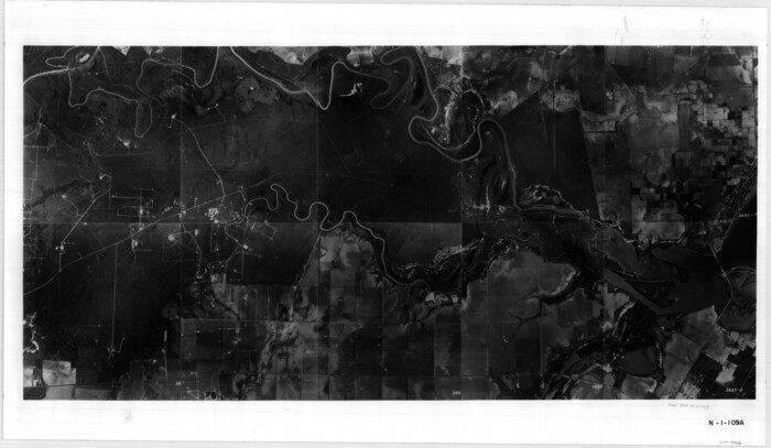
Matagorda County Rolled Sketch 37A

Print $40.00
- Digital $50.00
Matagorda County Rolled Sketch 37A
Size: 48.7 x 41.1 inches
10195
Matagorda County Rolled Sketch 37C

Print $20.00
- Digital $50.00
Matagorda County Rolled Sketch 37C
Size: 11.6 x 14.3 inches
10197

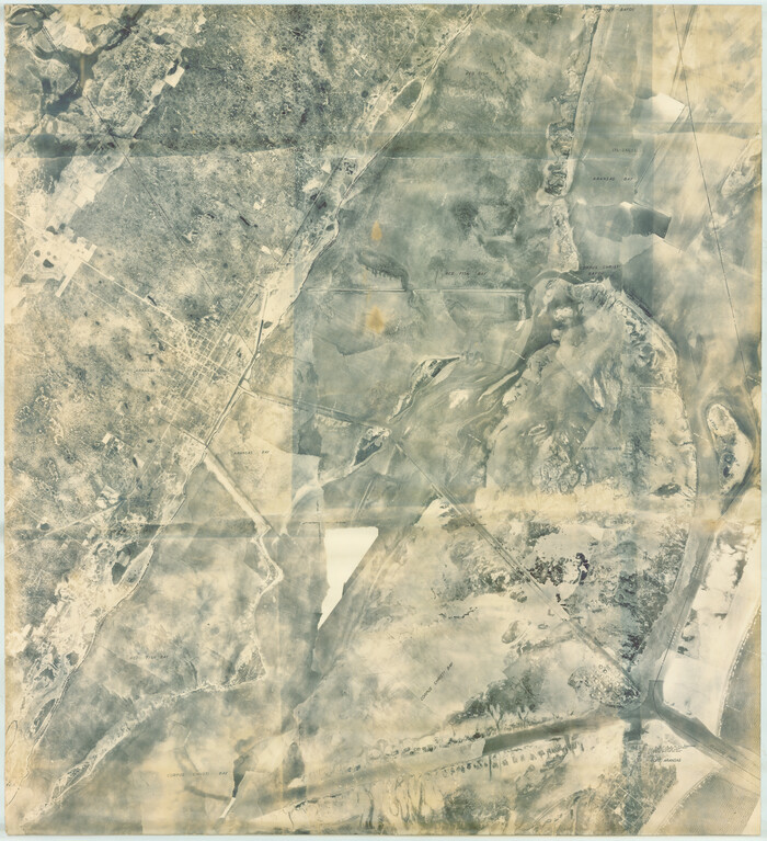
Aransas County Rolled Sketch 19C

Print $20.00
- Digital $50.00
Aransas County Rolled Sketch 19C
Size: 40.9 x 30.6 inches
5063
[Aerial photograph showing R. H. Welder Ranch, San Patricio County, Texas]
Print $20.00
- Digital $50.00
[Aerial photograph showing R. H. Welder Ranch, San Patricio County, Texas]
Size: 23.0 x 39.5 inches
61407
Aransas County Rolled Sketch 15B

Print $20.00
- Digital $50.00
Aransas County Rolled Sketch 15B
Size: 19.0 x 19.8 inches
76066
Aransas County Rolled Sketch 25A-25E

Print $20.00
- Digital $50.00
Aransas County Rolled Sketch 25A-25E
Size: 24.6 x 39.5 inches
76078


Nueces County Rolled Sketch 98B

Print $20.00
- Digital $50.00
Nueces County Rolled Sketch 98B
Size: 33.5 x 32.7 inches
9632
Mosaic composed of aerial photographs - Galveston, Tex.

Print $20.00
- Digital $50.00
Mosaic composed of aerial photographs - Galveston, Tex.
1923
Size: 15.3 x 33.3 inches
97160
Mosaic composed of aerial photographs - Texas City, Tex.

Print $20.00
- Digital $50.00
Mosaic composed of aerial photographs - Texas City, Tex.
1923
Size: 15.0 x 16.8 inches
97166
Mosaic composed of aerial photographs - Houston Ship Channel, Tex.

Print $20.00
- Digital $50.00
Mosaic composed of aerial photographs - Houston Ship Channel, Tex.
1923
Size: 13.7 x 38.0 inches
97172
Aransas County Rolled Sketch 27A

Print $2.00
- Digital $50.00
Aransas County Rolled Sketch 27A
1930
Size: 8.9 x 7.2 inches
5058
Cameron County Rolled Sketch 30

Print $20.00
- Digital $50.00
Cameron County Rolled Sketch 30
1930
Size: 36.3 x 24.4 inches
5394
Aransas County Rolled Sketch 27D

Print $20.00
- Digital $50.00
Aransas County Rolled Sketch 27D
1930
Size: 40.5 x 40.2 inches
8418
[Redfish Bay, Aransas Pass, and part of Mustang Island]
Print $40.00
- Digital $50.00
[Redfish Bay, Aransas Pass, and part of Mustang Island]
1930
Size: 51.0 x 46.5 inches
83009
Map of Ramon Musquiz Survey, Meanders of Lavaca & Navidad Rivers, Menefee & Redfish Lakes

Print $20.00
- Digital $50.00
Map of Ramon Musquiz Survey, Meanders of Lavaca & Navidad Rivers, Menefee & Redfish Lakes
1934
Size: 23.4 x 18.4 inches
65455
Map of Ramon Musquiz Survey, Meanders of Lavaca & Navidad Rivers, Menefee & Redfish Lakes

Print $20.00
- Digital $50.00
Map of Ramon Musquiz Survey, Meanders of Lavaca & Navidad Rivers, Menefee & Redfish Lakes
1934
Size: 23.0 x 18.6 inches
65456
Smith County Rolled Sketch 6A2

Print $40.00
- Digital $50.00
Smith County Rolled Sketch 6A2
1934
Size: 48.7 x 36.7 inches
10702
Aerial Perspective of Packery Channel

Print $20.00
- Digital $50.00
Aerial Perspective of Packery Channel
1938
Size: 16.5 x 19.3 inches
3001
Nueces County Aerial Photograph Index Sheet 21

Print $20.00
- Digital $50.00
Nueces County Aerial Photograph Index Sheet 21
1938
Size: 24.3 x 20.2 inches
86842
Nueces County Aerial Photograph Index Sheet 22

Print $20.00
- Digital $50.00
Nueces County Aerial Photograph Index Sheet 22
1938
Size: 24.5 x 20.3 inches
86843
Nueces County Aerial Photograph Index Sheet 23

Print $20.00
- Digital $50.00
Nueces County Aerial Photograph Index Sheet 23
1938
Size: 24.4 x 20.3 inches
86844
[Nueces Bay Islands and Nesting Birds]
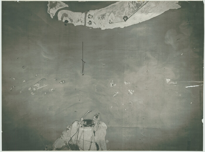
Print $20.00
- Digital $50.00
[Nueces Bay Islands and Nesting Birds]
1940
Size: 18.1 x 24.2 inches
2084
[Nueces Bay Islands and Nesting Birds]
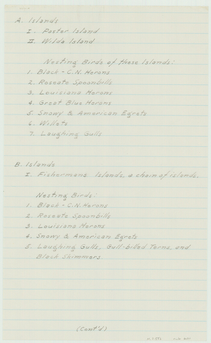
Print $2.00
- Digital $50.00
[Nueces Bay Islands and Nesting Birds]
1940
Size: 11.5 x 7.1 inches
60311
Matagorda County Rolled Sketch 37A
Print $40.00
- Digital $50.00
Matagorda County Rolled Sketch 37A
-
Size
48.7 x 41.1 inches
-
Map/Doc
10195
Matagorda County Rolled Sketch 37C
Print $20.00
- Digital $50.00
Matagorda County Rolled Sketch 37C
-
Size
11.6 x 14.3 inches
-
Map/Doc
10197
Aransas County Rolled Sketch 19C
Print $20.00
- Digital $50.00
Aransas County Rolled Sketch 19C
-
Size
40.9 x 30.6 inches
-
Map/Doc
5063
[Aerial photograph showing R. H. Welder Ranch, San Patricio County, Texas]
Print $20.00
- Digital $50.00
[Aerial photograph showing R. H. Welder Ranch, San Patricio County, Texas]
-
Size
23.0 x 39.5 inches
-
Map/Doc
61407
Aransas County Rolled Sketch 15B
Print $20.00
- Digital $50.00
Aransas County Rolled Sketch 15B
-
Size
19.0 x 19.8 inches
-
Map/Doc
76066
Aransas County Rolled Sketch 25A-25E
Print $20.00
- Digital $50.00
Aransas County Rolled Sketch 25A-25E
-
Size
24.6 x 39.5 inches
-
Map/Doc
76078
Nueces County Rolled Sketch 98B
Print $20.00
- Digital $50.00
Nueces County Rolled Sketch 98B
-
Size
33.5 x 32.7 inches
-
Map/Doc
9632
Mosaic composed of aerial photographs - Galveston, Tex.
Print $20.00
- Digital $50.00
Mosaic composed of aerial photographs - Galveston, Tex.
1923
-
Size
15.3 x 33.3 inches
-
Map/Doc
97160
-
Creation Date
1923
Mosaic composed of aerial photographs - Texas City, Tex.
Print $20.00
- Digital $50.00
Mosaic composed of aerial photographs - Texas City, Tex.
1923
-
Size
15.0 x 16.8 inches
-
Map/Doc
97166
-
Creation Date
1923
Mosaic composed of aerial photographs - Houston Ship Channel, Tex.
Print $20.00
- Digital $50.00
Mosaic composed of aerial photographs - Houston Ship Channel, Tex.
1923
-
Size
13.7 x 38.0 inches
-
Map/Doc
97172
-
Creation Date
1923
Packery Channel

Print $20.00
- Digital $50.00
Packery Channel
1930
-
Size
26.6 x 37.1 inches
-
Map/Doc
2990
-
Creation Date
1930
Aransas County Rolled Sketch 27A
Print $2.00
- Digital $50.00
Aransas County Rolled Sketch 27A
1930
-
Size
8.9 x 7.2 inches
-
Map/Doc
5058
-
Creation Date
1930
Cameron County Rolled Sketch 30
Print $20.00
- Digital $50.00
Cameron County Rolled Sketch 30
1930
-
Size
36.3 x 24.4 inches
-
Map/Doc
5394
-
Creation Date
1930
Aransas County Rolled Sketch 27D
Print $20.00
- Digital $50.00
Aransas County Rolled Sketch 27D
1930
-
Size
40.5 x 40.2 inches
-
Map/Doc
8418
-
Creation Date
1930
[Redfish Bay, Aransas Pass, and part of Mustang Island]
Print $40.00
- Digital $50.00
[Redfish Bay, Aransas Pass, and part of Mustang Island]
1930
-
Size
51.0 x 46.5 inches
-
Map/Doc
83009
-
Creation Date
1930
Map of Ramon Musquiz Survey, Meanders of Lavaca & Navidad Rivers, Menefee & Redfish Lakes
Print $20.00
- Digital $50.00
Map of Ramon Musquiz Survey, Meanders of Lavaca & Navidad Rivers, Menefee & Redfish Lakes
1934
-
Size
23.4 x 18.4 inches
-
Map/Doc
65455
-
Creation Date
1934
Map of Ramon Musquiz Survey, Meanders of Lavaca & Navidad Rivers, Menefee & Redfish Lakes
Print $20.00
- Digital $50.00
Map of Ramon Musquiz Survey, Meanders of Lavaca & Navidad Rivers, Menefee & Redfish Lakes
1934
-
Size
23.0 x 18.6 inches
-
Map/Doc
65456
-
Creation Date
1934
Smith County Rolled Sketch 6A2
Print $40.00
- Digital $50.00
Smith County Rolled Sketch 6A2
1934
-
Size
48.7 x 36.7 inches
-
Map/Doc
10702
-
Creation Date
1934
Packery Channel

Print $20.00
- Digital $50.00
Packery Channel
1937
-
Size
23.8 x 22.4 inches
-
Map/Doc
3008
-
Creation Date
1937
Aerial Photos

Print $20.00
- Digital $50.00
Aerial Photos
1937
-
Size
15.9 x 12.4 inches
-
Map/Doc
92106
-
Creation Date
1937
Aerial Perspective of Packery Channel
Print $20.00
- Digital $50.00
Aerial Perspective of Packery Channel
1938
-
Size
16.5 x 19.3 inches
-
Map/Doc
3001
-
Creation Date
1938
Nueces County Aerial Photograph Index Sheet 21
Print $20.00
- Digital $50.00
Nueces County Aerial Photograph Index Sheet 21
1938
-
Size
24.3 x 20.2 inches
-
Map/Doc
86842
-
Creation Date
1938
Nueces County Aerial Photograph Index Sheet 22
Print $20.00
- Digital $50.00
Nueces County Aerial Photograph Index Sheet 22
1938
-
Size
24.5 x 20.3 inches
-
Map/Doc
86843
-
Creation Date
1938
Nueces County Aerial Photograph Index Sheet 23
Print $20.00
- Digital $50.00
Nueces County Aerial Photograph Index Sheet 23
1938
-
Size
24.4 x 20.3 inches
-
Map/Doc
86844
-
Creation Date
1938
[Nueces Bay Islands and Nesting Birds]
Print $20.00
- Digital $50.00
[Nueces Bay Islands and Nesting Birds]
1940
-
Size
18.1 x 24.2 inches
-
Map/Doc
2084
-
Creation Date
1940
[Nueces Bay Islands and Nesting Birds]
Print $2.00
- Digital $50.00
[Nueces Bay Islands and Nesting Birds]
1940
-
Size
11.5 x 7.1 inches
-
Map/Doc
60311
-
Creation Date
1940