Current Miscellaneous File 8

Print $10.00
- Digital $50.00
Current Miscellaneous File 8
Size: 14.6 x 9.1 inches
73736
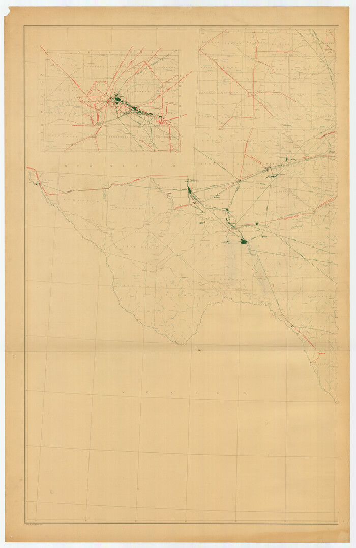
[Oil and Gas Fields in West Texas]
Print $40.00
- Digital $50.00
[Oil and Gas Fields in West Texas]
Size: 38.5 x 59.2 inches
89884

A map of the Anthracite Coal Fields of Pennsylvania embracing all of Schuylkill County and parts of Carbon, Luzerne, Columbia, Northumberland, Dauphin, and Lebanon Counties

Print $20.00
- Digital $50.00
A map of the Anthracite Coal Fields of Pennsylvania embracing all of Schuylkill County and parts of Carbon, Luzerne, Columbia, Northumberland, Dauphin, and Lebanon Counties
1863
Size: 27.1 x 39.3 inches
94054
Gray's Geological Map of the United States

Print $20.00
- Digital $50.00
Gray's Geological Map of the United States
1873
Size: 17.6 x 28.8 inches
95174
Revised map of Jefferson County, Texas showing land surveys, railroads and water ways

Print $20.00
- Digital $50.00
Revised map of Jefferson County, Texas showing land surveys, railroads and water ways
1898
Size: 27.2 x 24.1 inches
95912
Clarke and Courts' Map of Jefferson County and Beaumont and Sour Lake Oil Fields

Print $20.00
Clarke and Courts' Map of Jefferson County and Beaumont and Sour Lake Oil Fields
1901
Size: 28.2 x 24.3 inches
79289
Oil Fields of the Texas-Louisiana Gulf Coastal Plain

Oil Fields of the Texas-Louisiana Gulf Coastal Plain
1903
97518
Geological Report on Robertson County

Print $20.00
- Digital $50.00
Geological Report on Robertson County
1918
Size: 21.7 x 25.8 inches
97084
Map of Central Texas Oil Fields

Print $20.00
Map of Central Texas Oil Fields
1918
Size: 27.1 x 21.5 inches
76295
Clason's Oil Map of Texas and Oklahoma showing the location and approximate area of the oil and gas fields

Print $20.00
- Digital $50.00
Clason's Oil Map of Texas and Oklahoma showing the location and approximate area of the oil and gas fields
1919
Size: 22.4 x 24.5 inches
97158
Geological Petroleum Corporation Map of North Central Texas

Print $20.00
Geological Petroleum Corporation Map of North Central Texas
1920
Size: 37.4 x 28.4 inches
79305
Gallup's Map of Texas

Print $20.00
- Digital $50.00
Gallup's Map of Texas
1920
Size: 22.4 x 31.9 inches
95696
Oil Map of Texas and Oklahoma showing the location and approximate area of the Oil and Gas Fields

Print $20.00
- Digital $50.00
Oil Map of Texas and Oklahoma showing the location and approximate area of the Oil and Gas Fields
1920
Size: 20.8 x 23.9 inches
95897
New Oil and Geological Map of Texas showing Oil Fields, Pipe Lines, Refineries, Geological Formations, Etc.

Print $20.00
- Digital $50.00
New Oil and Geological Map of Texas showing Oil Fields, Pipe Lines, Refineries, Geological Formations, Etc.
1920
Size: 22.5 x 31.3 inches
96633
Souvenir - Opening and Dedication of the General Oil Company's New West Texas Oil Field

Souvenir - Opening and Dedication of the General Oil Company's New West Texas Oil Field
1920
97263
Oil Development and Structural Map showing Schott, Mirando and other oil fields of the Laredo District with present and proposed development.

Print $20.00
- Digital $50.00
Oil Development and Structural Map showing Schott, Mirando and other oil fields of the Laredo District with present and proposed development.
1920
Size: 11.3 x 8.9 inches
94107
Geological Map of the Great East Texas Oil Fields

Print $20.00
- Digital $50.00
Geological Map of the Great East Texas Oil Fields
1921
Size: 22.6 x 11.7 inches
94271
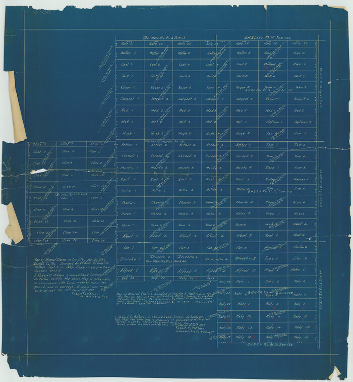
[Sketch for Mineral Application 13436 - 13441]
Print $40.00
- Digital $50.00
[Sketch for Mineral Application 13436 - 13441]
1925
Size: 56.8 x 42.4 inches
65581
[Sketch for Mineral Application 13436 - 13441]
Print $40.00
- Digital $50.00
[Sketch for Mineral Application 13436 - 13441]
1925
Size: 56.8 x 42.5 inches
65582
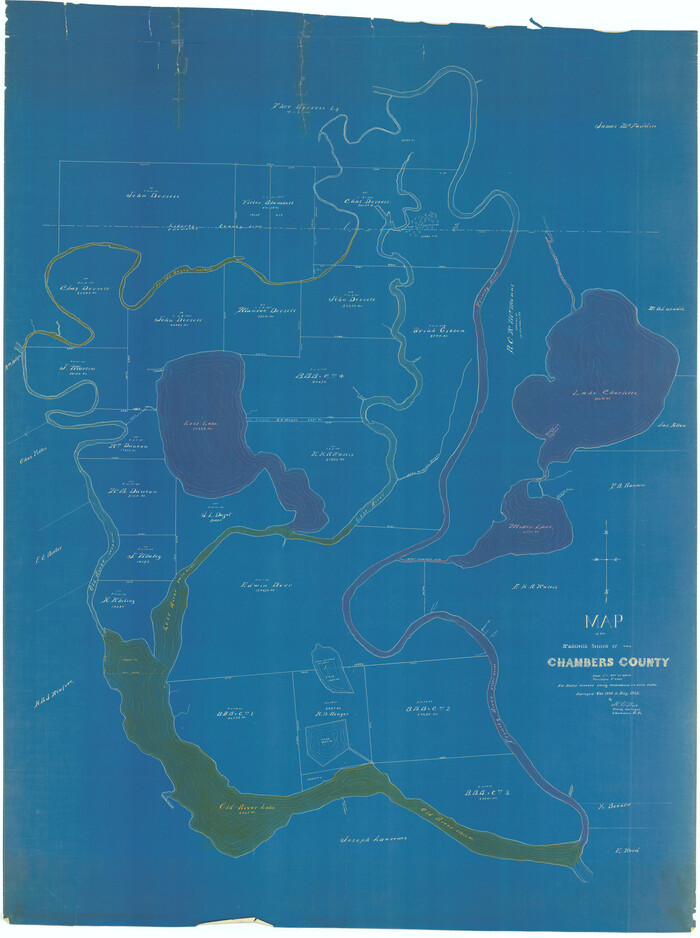
[Sketch for Mineral Application 13441 - Trinity River, Miller's Lake, Charlotte Lake, Florence Dunn]
Print $40.00
- Digital $50.00
[Sketch for Mineral Application 13441 - Trinity River, Miller's Lake, Charlotte Lake, Florence Dunn]
1925
Size: 104.1 x 43.3 inches
65657
[Sketch for Mineral Application 13441 - Trinity River, Miller's Lake, Charlotte Lake, Florence Dunn]
Print $40.00
- Digital $50.00
[Sketch for Mineral Application 13441 - Trinity River, Miller's Lake, Charlotte Lake, Florence Dunn]
1925
Size: 103.6 x 43.1 inches
65658
Texas Oil and Gas Fields and Truck Pipe Line Systems

Print $20.00
Texas Oil and Gas Fields and Truck Pipe Line Systems
1926
Size: 21.7 x 30.8 inches
79327
Oil and Gas Fields in the State of Texas

Print $40.00
Oil and Gas Fields in the State of Texas
1927
Size: 58.0 x 38.0 inches
76304
[Sketch for M-12871 to M-13240 - Presidio County]
Print $20.00
- Digital $50.00
[Sketch for M-12871 to M-13240 - Presidio County]
1927
Size: 33.0 x 30.5 inches
65649
[Sketch for M-12871 to M-13240 - Presidio County]
Print $20.00
- Digital $50.00
[Sketch for M-12871 to M-13240 - Presidio County]
1927
Size: 30.6 x 33.0 inches
65650
Oil and Gas Fields in the State of Texas

Print $40.00
Oil and Gas Fields in the State of Texas
1927
Size: 58.2 x 38.1 inches
76303
Oil and Gas Fields of the State of Texas

Print $40.00
- Digital $50.00
Oil and Gas Fields of the State of Texas
1931
Size: 38.4 x 59.2 inches
89885
Texas-Louisiana Gulf Coastal Region showing Oil & Gas Fields & Prospects, Pipe Lines, Refineries & Principal Highways

Print $20.00
- Digital $50.00
Texas-Louisiana Gulf Coastal Region showing Oil & Gas Fields & Prospects, Pipe Lines, Refineries & Principal Highways
1933
Size: 22.4 x 44.2 inches
96874
Map of East Texas Oil Field

Print $20.00
- Digital $50.00
Map of East Texas Oil Field
1933
Size: 16.5 x 17.8 inches
93949
Current Miscellaneous File 8
Print $10.00
- Digital $50.00
Current Miscellaneous File 8
-
Size
14.6 x 9.1 inches
-
Map/Doc
73736
[Oil and Gas Fields in West Texas]
Print $40.00
- Digital $50.00
[Oil and Gas Fields in West Texas]
-
Size
38.5 x 59.2 inches
-
Map/Doc
89884
A map of the Anthracite Coal Fields of Pennsylvania embracing all of Schuylkill County and parts of Carbon, Luzerne, Columbia, Northumberland, Dauphin, and Lebanon Counties
Print $20.00
- Digital $50.00
A map of the Anthracite Coal Fields of Pennsylvania embracing all of Schuylkill County and parts of Carbon, Luzerne, Columbia, Northumberland, Dauphin, and Lebanon Counties
1863
-
Size
27.1 x 39.3 inches
-
Map/Doc
94054
-
Creation Date
1863
Gray's Geological Map of the United States
Print $20.00
- Digital $50.00
Gray's Geological Map of the United States
1873
-
Size
17.6 x 28.8 inches
-
Map/Doc
95174
-
Creation Date
1873
Revised map of Jefferson County, Texas showing land surveys, railroads and water ways
Print $20.00
- Digital $50.00
Revised map of Jefferson County, Texas showing land surveys, railroads and water ways
1898
-
Size
27.2 x 24.1 inches
-
Map/Doc
95912
-
Creation Date
1898
Clarke and Courts' Map of Jefferson County and Beaumont and Sour Lake Oil Fields
Print $20.00
Clarke and Courts' Map of Jefferson County and Beaumont and Sour Lake Oil Fields
1901
-
Size
28.2 x 24.3 inches
-
Map/Doc
79289
-
Creation Date
1901
Oil Fields of the Texas-Louisiana Gulf Coastal Plain
Oil Fields of the Texas-Louisiana Gulf Coastal Plain
1903
-
Map/Doc
97518
-
Creation Date
1903
Geological Report on Robertson County
Print $20.00
- Digital $50.00
Geological Report on Robertson County
1918
-
Size
21.7 x 25.8 inches
-
Map/Doc
97084
-
Creation Date
1918
Map of Central Texas Oil Fields
Print $20.00
Map of Central Texas Oil Fields
1918
-
Size
27.1 x 21.5 inches
-
Map/Doc
76295
-
Creation Date
1918
Clason's Oil Map of Texas and Oklahoma showing the location and approximate area of the oil and gas fields
Print $20.00
- Digital $50.00
Clason's Oil Map of Texas and Oklahoma showing the location and approximate area of the oil and gas fields
1919
-
Size
22.4 x 24.5 inches
-
Map/Doc
97158
-
Creation Date
1919
Geological Petroleum Corporation Map of North Central Texas
Print $20.00
Geological Petroleum Corporation Map of North Central Texas
1920
-
Size
37.4 x 28.4 inches
-
Map/Doc
79305
-
Creation Date
1920
Gallup's Map of Texas
Print $20.00
- Digital $50.00
Gallup's Map of Texas
1920
-
Size
22.4 x 31.9 inches
-
Map/Doc
95696
-
Creation Date
1920
Oil Map of Texas and Oklahoma showing the location and approximate area of the Oil and Gas Fields
Print $20.00
- Digital $50.00
Oil Map of Texas and Oklahoma showing the location and approximate area of the Oil and Gas Fields
1920
-
Size
20.8 x 23.9 inches
-
Map/Doc
95897
-
Creation Date
1920
New Oil and Geological Map of Texas showing Oil Fields, Pipe Lines, Refineries, Geological Formations, Etc.
Print $20.00
- Digital $50.00
New Oil and Geological Map of Texas showing Oil Fields, Pipe Lines, Refineries, Geological Formations, Etc.
1920
-
Size
22.5 x 31.3 inches
-
Map/Doc
96633
-
Creation Date
1920
Souvenir - Opening and Dedication of the General Oil Company's New West Texas Oil Field
Souvenir - Opening and Dedication of the General Oil Company's New West Texas Oil Field
1920
-
Map/Doc
97263
-
Creation Date
1920
Oil Development and Structural Map showing Schott, Mirando and other oil fields of the Laredo District with present and proposed development.
Print $20.00
- Digital $50.00
Oil Development and Structural Map showing Schott, Mirando and other oil fields of the Laredo District with present and proposed development.
1920
-
Size
11.3 x 8.9 inches
-
Map/Doc
94107
-
Creation Date
1920
Geological Map of the Great East Texas Oil Fields
Print $20.00
- Digital $50.00
Geological Map of the Great East Texas Oil Fields
1921
-
Size
22.6 x 11.7 inches
-
Map/Doc
94271
-
Creation Date
1921
[Sketch for Mineral Application 13436 - 13441]
Print $40.00
- Digital $50.00
[Sketch for Mineral Application 13436 - 13441]
1925
-
Size
56.8 x 42.4 inches
-
Map/Doc
65581
-
Creation Date
1925
[Sketch for Mineral Application 13436 - 13441]
Print $40.00
- Digital $50.00
[Sketch for Mineral Application 13436 - 13441]
1925
-
Size
56.8 x 42.5 inches
-
Map/Doc
65582
-
Creation Date
1925
[Sketch for Mineral Application 13441 - Trinity River, Miller's Lake, Charlotte Lake, Florence Dunn]
Print $40.00
- Digital $50.00
[Sketch for Mineral Application 13441 - Trinity River, Miller's Lake, Charlotte Lake, Florence Dunn]
1925
-
Size
104.1 x 43.3 inches
-
Map/Doc
65657
-
Creation Date
1925
[Sketch for Mineral Application 13441 - Trinity River, Miller's Lake, Charlotte Lake, Florence Dunn]
Print $40.00
- Digital $50.00
[Sketch for Mineral Application 13441 - Trinity River, Miller's Lake, Charlotte Lake, Florence Dunn]
1925
-
Size
103.6 x 43.1 inches
-
Map/Doc
65658
-
Creation Date
1925
Texas Oil and Gas Fields and Truck Pipe Line Systems
Print $20.00
Texas Oil and Gas Fields and Truck Pipe Line Systems
1926
-
Size
21.7 x 30.8 inches
-
Map/Doc
79327
-
Creation Date
1926
Oil and Gas Fields in the State of Texas
Print $40.00
Oil and Gas Fields in the State of Texas
1927
-
Size
58.0 x 38.0 inches
-
Map/Doc
76304
-
Creation Date
1927
[Sketch for M-12871 to M-13240 - Presidio County]
Print $20.00
- Digital $50.00
[Sketch for M-12871 to M-13240 - Presidio County]
1927
-
Size
33.0 x 30.5 inches
-
Map/Doc
65649
-
Creation Date
1927
[Sketch for M-12871 to M-13240 - Presidio County]
Print $20.00
- Digital $50.00
[Sketch for M-12871 to M-13240 - Presidio County]
1927
-
Size
30.6 x 33.0 inches
-
Map/Doc
65650
-
Creation Date
1927
Oil and Gas Fields in the State of Texas
Print $40.00
Oil and Gas Fields in the State of Texas
1927
-
Size
58.2 x 38.1 inches
-
Map/Doc
76303
-
Creation Date
1927
Oil and Gas Fields of the State of Texas
Print $40.00
- Digital $50.00
Oil and Gas Fields of the State of Texas
1931
-
Size
38.4 x 59.2 inches
-
Map/Doc
89885
-
Creation Date
1931
Texas-Louisiana Gulf Coastal Region showing Oil & Gas Fields & Prospects, Pipe Lines, Refineries & Principal Highways
Print $20.00
- Digital $50.00
Texas-Louisiana Gulf Coastal Region showing Oil & Gas Fields & Prospects, Pipe Lines, Refineries & Principal Highways
1933
-
Size
22.4 x 44.2 inches
-
Map/Doc
96874
-
Creation Date
1933
Map of East Texas Oil Field
Print $20.00
- Digital $50.00
Map of East Texas Oil Field
1933
-
Size
16.5 x 17.8 inches
-
Map/Doc
93949
-
Creation Date
1933