[Three-Marine League line stipulation as determined by US Supreme Court, October 1968 term; corrections to stipulation; Texas GLO approximations of county areas embraced by county boundaries, shoreline and 3-marine league line and 3-mile line]

Print $64.00
[Three-Marine League line stipulation as determined by US Supreme Court, October 1968 term; corrections to stipulation; Texas GLO approximations of county areas embraced by county boundaries, shoreline and 3-marine league line and 3-mile line]
1962
Size: 13.4 x 8.7 inches
61371
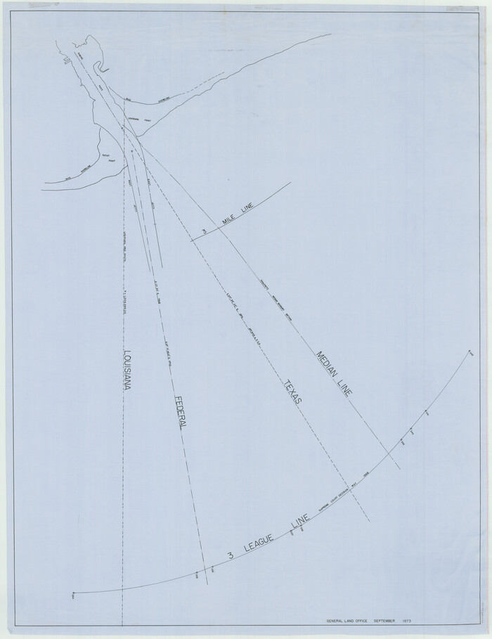
[Three Mile Line and Three League Line]
Print $20.00
- Digital $50.00
[Three Mile Line and Three League Line]
1973
Size: 43.2 x 33.3 inches
76120
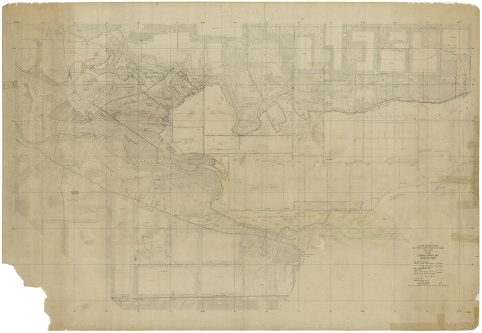
[Subdivision of Nueces Bay and list of Court Decrees]
Print $40.00
- Digital $50.00
[Subdivision of Nueces Bay and list of Court Decrees]
1940
Size: 34.2 x 48.8 inches
2086
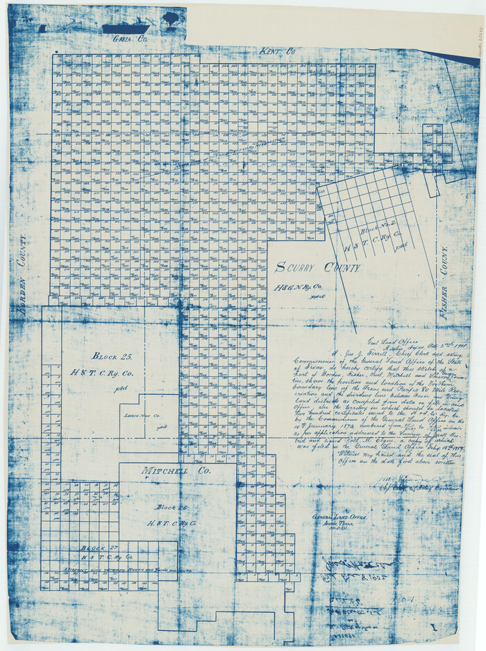
[Map of Block 97, Borden and Scurry Co (Exhibit A); Map of Southeastern part of Young Territory; Map of part of of Borden, Fisher, Kent, Mitchell, Scurry and Garza Cos. Showing the north boundary line of the T&P 80 mile reservation]
Print $20.00
- Digital $50.00
[Map of Block 97, Borden and Scurry Co (Exhibit A); Map of Southeastern part of Young Territory; Map of part of of Borden, Fisher, Kent, Mitchell, Scurry and Garza Cos. Showing the north boundary line of the T&P 80 mile reservation]
1901
Size: 31.2 x 23.3 inches
65693
[Field notes, sketch and legislation regarding the National Road from Dallas at the mouth of the Elm Fork of the Trinity to the mouth of Kiamechi on Red River]
![65469, [Field notes, sketch and legislation regarding the National Road from Dallas at the mouth of the Elm Fork of the Trinity to the mouth of Kiamechi on Red River], General Map Collection](https://historictexasmaps.com/wmedia_w700/pdf_converted_jpg/qi_pdf_thumbnail_19857.jpg)
Print $84.00
- Digital $50.00
[Field notes, sketch and legislation regarding the National Road from Dallas at the mouth of the Elm Fork of the Trinity to the mouth of Kiamechi on Red River]
1844
Size: 6.8 x 11.2 inches
65469

Vacancy Application - John H. Tyler near T.C. Ry. Co. Block 1 Surveys 101, 102, 103, & 104. Letters and Maps, Pecos County

Print $279.00
- Digital $50.00
Vacancy Application - John H. Tyler near T.C. Ry. Co. Block 1 Surveys 101, 102, 103, & 104. Letters and Maps, Pecos County
1934
Size: 18.1 x 21.1 inches
2048
The State of Texas vs. Chas. J. Canda, et al, T. & P. Ry. Co., No. 10351

Print $522.00
- Digital $50.00
The State of Texas vs. Chas. J. Canda, et al, T. & P. Ry. Co., No. 10351
1893
Size: 10.0 x 17.0 inches
3048
Tarrant County Boundary File 6

Print $70.00
- Digital $50.00
Tarrant County Boundary File 6
2004
Size: 11.0 x 8.5 inches
83178
Supreme Court of the United States, October Term, 1930, No.2, Original - The State of New Mexico, Complainant vs. The State of Texas, Defendant

Print $138.00
- Digital $50.00
Supreme Court of the United States, October Term, 1930, No.2, Original - The State of New Mexico, Complainant vs. The State of Texas, Defendant
Size: 9.2 x 6.0 inches
95287
Supreme Court of the United States, October Term, 1923, No. 15, Original - The State of Oklahoma, Complainant vs. The State of Texas, Defendant, The United States, Intervener; Report of the Boundary Commissioners

Print $98.00
- Digital $50.00
Supreme Court of the United States, October Term, 1923, No. 15, Original - The State of Oklahoma, Complainant vs. The State of Texas, Defendant, The United States, Intervener; Report of the Boundary Commissioners
1924
Size: 6.1 x 9.2 inches
3058
Supreme Court of the United States, October Term, 1923, No. 15, Original - The State of Oklahoma, Complainant vs. The State of Texas, Defendant, The United States, Intervener; Report of Medial Line Survey

Print $28.00
- Digital $50.00
Supreme Court of the United States, October Term, 1923, No. 15, Original - The State of Oklahoma, Complainant vs. The State of Texas, Defendant, The United States, Intervener; Report of Medial Line Survey
1924
Size: 5.9 x 9.1 inches
3055
Supreme Court of the United States October Term, 1926, No. 6, Original - State of Oklahoma, Complainant vs. The State of Texas, Defendant, the United States, Intervener; Fourth Report of the Boundary Commissioners

Print $482.00
- Digital $50.00
Supreme Court of the United States October Term, 1926, No. 6, Original - State of Oklahoma, Complainant vs. The State of Texas, Defendant, the United States, Intervener; Fourth Report of the Boundary Commissioners
1927
Size: 6.0 x 9.2 inches
3060
Statement of Facts - State of Texas vs. F. B. Olcott, Cause 17090, 12/18/1902

Print $2.00
- Digital $50.00
Statement of Facts - State of Texas vs. F. B. Olcott, Cause 17090, 12/18/1902
1902
Size: 14.3 x 8.9 inches
65724
Plat showing proposed counties to be taken from Zapata, Starr & Hidalgo Counties

Print $20.00
- Digital $50.00
Plat showing proposed counties to be taken from Zapata, Starr & Hidalgo Counties
1911
Size: 24.8 x 27.0 inches
2478
Plat showing proposed counties to be taken from Zapata, Starr & Hidalgo Counties

Print $20.00
- Digital $50.00
Plat showing proposed counties to be taken from Zapata, Starr & Hidalgo Counties
1911
Size: 24.8 x 27.8 inches
2660
Old Miscellaneous File 9

Print $4.00
- Digital $50.00
Old Miscellaneous File 9
1871
Size: 9.8 x 8.0 inches
75433
Old Miscellaneous File 37

Print $4.00
- Digital $50.00
Old Miscellaneous File 37
1912
Size: 11.2 x 8.8 inches
75280
Old Miscellaneous File 34

Print $4.00
- Digital $50.00
Old Miscellaneous File 34
1881
Size: 9.8 x 8.0 inches
75755
Old Miscellaneous File 28

Print $6.00
- Digital $50.00
Old Miscellaneous File 28
1838
Size: 10.2 x 8.4 inches
75736
Old Miscellaneous File 27c

Print $18.00
- Digital $50.00
Old Miscellaneous File 27c
1880
Size: 14.1 x 8.6 inches
75727
Old Miscellaneous File 27b

Print $10.00
- Digital $50.00
Old Miscellaneous File 27b
1880
Size: 14.3 x 8.8 inches
75722
Old Miscellaneous File 26

Print $4.00
- Digital $50.00
Old Miscellaneous File 26
Size: 14.3 x 9.0 inches
75634
Old Miscellaneous File 24

Print $6.00
- Digital $50.00
Old Miscellaneous File 24
1919
Size: 14.4 x 8.7 inches
75629
Old Miscellaneous File 23

Print $58.00
- Digital $50.00
Old Miscellaneous File 23
1919
Size: 14.2 x 8.6 inches
75600
Old Miscellaneous File 22

Print $18.00
- Digital $50.00
Old Miscellaneous File 22
1915
Size: 14.2 x 8.7 inches
75591
Old Miscellaneous File 21

Print $16.00
- Digital $50.00
Old Miscellaneous File 21
Size: 14.3 x 8.7 inches
75583
Old Miscellaneous File 20

Print $16.00
- Digital $50.00
Old Miscellaneous File 20
1913
Size: 13.6 x 7.9 inches
75575
Old Miscellaneous File 19

Print $32.00
- Digital $50.00
Old Miscellaneous File 19
Size: 14.2 x 8.8 inches
75499
Old Miscellaneous File 15

Print $12.00
- Digital $50.00
Old Miscellaneous File 15
1905
Size: 11.0 x 7.8 inches
75451
[Three-Marine League line stipulation as determined by US Supreme Court, October 1968 term; corrections to stipulation; Texas GLO approximations of county areas embraced by county boundaries, shoreline and 3-marine league line and 3-mile line]
Print $64.00
[Three-Marine League line stipulation as determined by US Supreme Court, October 1968 term; corrections to stipulation; Texas GLO approximations of county areas embraced by county boundaries, shoreline and 3-marine league line and 3-mile line]
1962
-
Size
13.4 x 8.7 inches
-
Map/Doc
61371
-
Creation Date
1962
[Three Mile Line and Three League Line]
Print $20.00
- Digital $50.00
[Three Mile Line and Three League Line]
1973
-
Size
43.2 x 33.3 inches
-
Map/Doc
76120
-
Creation Date
1973
[Subdivision of Nueces Bay and list of Court Decrees]
Print $40.00
- Digital $50.00
[Subdivision of Nueces Bay and list of Court Decrees]
1940
-
Size
34.2 x 48.8 inches
-
Map/Doc
2086
-
Creation Date
1940
[Map of Block 97, Borden and Scurry Co (Exhibit A); Map of Southeastern part of Young Territory; Map of part of of Borden, Fisher, Kent, Mitchell, Scurry and Garza Cos. Showing the north boundary line of the T&P 80 mile reservation]
Print $20.00
- Digital $50.00
[Map of Block 97, Borden and Scurry Co (Exhibit A); Map of Southeastern part of Young Territory; Map of part of of Borden, Fisher, Kent, Mitchell, Scurry and Garza Cos. Showing the north boundary line of the T&P 80 mile reservation]
1901
-
Size
31.2 x 23.3 inches
-
Map/Doc
65693
-
Creation Date
1901
[Field notes, sketch and legislation regarding the National Road from Dallas at the mouth of the Elm Fork of the Trinity to the mouth of Kiamechi on Red River]
Print $84.00
- Digital $50.00
[Field notes, sketch and legislation regarding the National Road from Dallas at the mouth of the Elm Fork of the Trinity to the mouth of Kiamechi on Red River]
1844
-
Size
6.8 x 11.2 inches
-
Map/Doc
65469
-
Creation Date
1844
Vacancy Application - John H. Tyler near T.C. Ry. Co. Block 1 Surveys 101, 102, 103, & 104. Letters and Maps, Pecos County
Print $279.00
- Digital $50.00
Vacancy Application - John H. Tyler near T.C. Ry. Co. Block 1 Surveys 101, 102, 103, & 104. Letters and Maps, Pecos County
1934
-
Size
18.1 x 21.1 inches
-
Map/Doc
2048
-
Creation Date
1934
The State of Texas vs. Chas. J. Canda, et al, T. & P. Ry. Co., No. 10351
Print $522.00
- Digital $50.00
The State of Texas vs. Chas. J. Canda, et al, T. & P. Ry. Co., No. 10351
1893
-
Size
10.0 x 17.0 inches
-
Map/Doc
3048
-
Creation Date
1893
Tarrant County Boundary File 6
Print $70.00
- Digital $50.00
Tarrant County Boundary File 6
2004
-
Size
11.0 x 8.5 inches
-
Map/Doc
83178
-
Creation Date
2004
Supreme Court of the United States, October Term, 1930, No.2, Original - The State of New Mexico, Complainant vs. The State of Texas, Defendant
Print $138.00
- Digital $50.00
Supreme Court of the United States, October Term, 1930, No.2, Original - The State of New Mexico, Complainant vs. The State of Texas, Defendant
-
Size
9.2 x 6.0 inches
-
Map/Doc
95287
Supreme Court of the United States, October Term, 1923, No. 15, Original - The State of Oklahoma, Complainant vs. The State of Texas, Defendant, The United States, Intervener; Report of the Boundary Commissioners
Print $98.00
- Digital $50.00
Supreme Court of the United States, October Term, 1923, No. 15, Original - The State of Oklahoma, Complainant vs. The State of Texas, Defendant, The United States, Intervener; Report of the Boundary Commissioners
1924
-
Size
6.1 x 9.2 inches
-
Map/Doc
3058
-
Creation Date
1924
Supreme Court of the United States, October Term, 1923, No. 15, Original - The State of Oklahoma, Complainant vs. The State of Texas, Defendant, The United States, Intervener; Report of Medial Line Survey
Print $28.00
- Digital $50.00
Supreme Court of the United States, October Term, 1923, No. 15, Original - The State of Oklahoma, Complainant vs. The State of Texas, Defendant, The United States, Intervener; Report of Medial Line Survey
1924
-
Size
5.9 x 9.1 inches
-
Map/Doc
3055
-
Creation Date
1924
Supreme Court of the United States October Term, 1926, No. 6, Original - State of Oklahoma, Complainant vs. The State of Texas, Defendant, the United States, Intervener; Fourth Report of the Boundary Commissioners
Print $482.00
- Digital $50.00
Supreme Court of the United States October Term, 1926, No. 6, Original - State of Oklahoma, Complainant vs. The State of Texas, Defendant, the United States, Intervener; Fourth Report of the Boundary Commissioners
1927
-
Size
6.0 x 9.2 inches
-
Map/Doc
3060
-
Creation Date
1927
Statement of Facts - State of Texas vs. F. B. Olcott, Cause 17090, 12/18/1902
Print $2.00
- Digital $50.00
Statement of Facts - State of Texas vs. F. B. Olcott, Cause 17090, 12/18/1902
1902
-
Size
14.3 x 8.9 inches
-
Map/Doc
65724
-
Creation Date
1902
Plat showing proposed counties to be taken from Zapata, Starr & Hidalgo Counties
Print $20.00
- Digital $50.00
Plat showing proposed counties to be taken from Zapata, Starr & Hidalgo Counties
1911
-
Size
24.8 x 27.0 inches
-
Map/Doc
2478
-
Creation Date
1911
Plat showing proposed counties to be taken from Zapata, Starr & Hidalgo Counties
Print $20.00
- Digital $50.00
Plat showing proposed counties to be taken from Zapata, Starr & Hidalgo Counties
1911
-
Size
24.8 x 27.8 inches
-
Map/Doc
2660
-
Creation Date
1911
Old Miscellaneous File 9
Print $4.00
- Digital $50.00
Old Miscellaneous File 9
1871
-
Size
9.8 x 8.0 inches
-
Map/Doc
75433
-
Creation Date
1871
Old Miscellaneous File 37
Print $4.00
- Digital $50.00
Old Miscellaneous File 37
1912
-
Size
11.2 x 8.8 inches
-
Map/Doc
75280
-
Creation Date
1912
Old Miscellaneous File 34
Print $4.00
- Digital $50.00
Old Miscellaneous File 34
1881
-
Size
9.8 x 8.0 inches
-
Map/Doc
75755
-
Creation Date
1881
Old Miscellaneous File 28
Print $6.00
- Digital $50.00
Old Miscellaneous File 28
1838
-
Size
10.2 x 8.4 inches
-
Map/Doc
75736
-
Creation Date
1838
Old Miscellaneous File 27c
Print $18.00
- Digital $50.00
Old Miscellaneous File 27c
1880
-
Size
14.1 x 8.6 inches
-
Map/Doc
75727
-
Creation Date
1880
Old Miscellaneous File 27b
Print $10.00
- Digital $50.00
Old Miscellaneous File 27b
1880
-
Size
14.3 x 8.8 inches
-
Map/Doc
75722
-
Creation Date
1880
Old Miscellaneous File 26
Print $4.00
- Digital $50.00
Old Miscellaneous File 26
-
Size
14.3 x 9.0 inches
-
Map/Doc
75634
Old Miscellaneous File 24
Print $6.00
- Digital $50.00
Old Miscellaneous File 24
1919
-
Size
14.4 x 8.7 inches
-
Map/Doc
75629
-
Creation Date
1919
Old Miscellaneous File 23
Print $58.00
- Digital $50.00
Old Miscellaneous File 23
1919
-
Size
14.2 x 8.6 inches
-
Map/Doc
75600
-
Creation Date
1919
Old Miscellaneous File 22
Print $18.00
- Digital $50.00
Old Miscellaneous File 22
1915
-
Size
14.2 x 8.7 inches
-
Map/Doc
75591
-
Creation Date
1915
Old Miscellaneous File 21
Print $16.00
- Digital $50.00
Old Miscellaneous File 21
-
Size
14.3 x 8.7 inches
-
Map/Doc
75583
Old Miscellaneous File 20
Print $16.00
- Digital $50.00
Old Miscellaneous File 20
1913
-
Size
13.6 x 7.9 inches
-
Map/Doc
75575
-
Creation Date
1913
Old Miscellaneous File 19
Print $32.00
- Digital $50.00
Old Miscellaneous File 19
-
Size
14.2 x 8.8 inches
-
Map/Doc
75499
Old Miscellaneous File 15
Print $12.00
- Digital $50.00
Old Miscellaneous File 15
1905
-
Size
11.0 x 7.8 inches
-
Map/Doc
75451
-
Creation Date
1905