Tarrant County Boundary File 6

Print $70.00
- Digital $50.00
Tarrant County Boundary File 6
2004
Size: 11.0 x 8.5 inches
83178
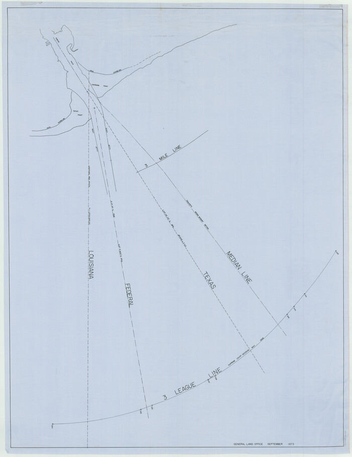
[Three Mile Line and Three League Line]
Print $20.00
- Digital $50.00
[Three Mile Line and Three League Line]
1973
Size: 43.2 x 33.3 inches
76120
[Three-Marine League line stipulation as determined by US Supreme Court, October 1968 term; corrections to stipulation; Texas GLO approximations of county areas embraced by county boundaries, shoreline and 3-marine league line and 3-mile line]

Print $64.00
[Three-Marine League line stipulation as determined by US Supreme Court, October 1968 term; corrections to stipulation; Texas GLO approximations of county areas embraced by county boundaries, shoreline and 3-marine league line and 3-mile line]
1962
Size: 13.4 x 8.7 inches
61371
Current Miscellaneous File 64

Print $12.00
- Digital $50.00
Current Miscellaneous File 64
1954
Size: 10.8 x 8.5 inches
74103
Current Miscellaneous File 56

Print $10.00
- Digital $50.00
Current Miscellaneous File 56
1954
Size: 12.2 x 9.2 inches
74045
Current Miscellaneous File 22

Print $12.00
- Digital $50.00
Current Miscellaneous File 22
1952
Size: 14.2 x 8.8 inches
73876
Current Miscellaneous File 115

Print $16.00
- Digital $50.00
Current Miscellaneous File 115
1950
Size: 11.3 x 8.8 inches
74811
Current Miscellaneous File 5

Print $8.00
- Digital $50.00
Current Miscellaneous File 5
1946
Size: 11.3 x 8.8 inches
73727
[Subdivision of Nueces Bay and list of Court Decrees]
Print $40.00
- Digital $50.00
[Subdivision of Nueces Bay and list of Court Decrees]
1940
Size: 34.2 x 48.8 inches
2086
Vacancy Application - John H. Tyler near T.C. Ry. Co. Block 1 Surveys 101, 102, 103, & 104. Letters and Maps, Pecos County

Print $279.00
- Digital $50.00
Vacancy Application - John H. Tyler near T.C. Ry. Co. Block 1 Surveys 101, 102, 103, & 104. Letters and Maps, Pecos County
1934
Size: 18.1 x 21.1 inches
2048
Current Miscellaneous File 101

Print $46.00
- Digital $50.00
Current Miscellaneous File 101
1931
Size: 8.8 x 14.2 inches
74357
Supreme Court of the United States October Term, 1926, No. 6, Original - State of Oklahoma, Complainant vs. The State of Texas, Defendant, the United States, Intervener; Fourth Report of the Boundary Commissioners

Print $482.00
- Digital $50.00
Supreme Court of the United States October Term, 1926, No. 6, Original - State of Oklahoma, Complainant vs. The State of Texas, Defendant, the United States, Intervener; Fourth Report of the Boundary Commissioners
1927
Size: 6.0 x 9.2 inches
3060
Supreme Court of the United States, October Term, 1923, No. 15, Original - The State of Oklahoma, Complainant vs. The State of Texas, Defendant, The United States, Intervener; Report of Medial Line Survey

Print $28.00
- Digital $50.00
Supreme Court of the United States, October Term, 1923, No. 15, Original - The State of Oklahoma, Complainant vs. The State of Texas, Defendant, The United States, Intervener; Report of Medial Line Survey
1924
Size: 5.9 x 9.1 inches
3055
Supreme Court of the United States, October Term, 1923, No. 15, Original - The State of Oklahoma, Complainant vs. The State of Texas, Defendant, The United States, Intervener; Report of the Boundary Commissioners

Print $98.00
- Digital $50.00
Supreme Court of the United States, October Term, 1923, No. 15, Original - The State of Oklahoma, Complainant vs. The State of Texas, Defendant, The United States, Intervener; Report of the Boundary Commissioners
1924
Size: 6.1 x 9.2 inches
3058
In the Supreme Court of the United States The State of Oklahoma, Complainant vs. The State of Texas, Defendant, The United States of America, Intervener - 1921

Print $40.00
- Digital $50.00
In the Supreme Court of the United States The State of Oklahoma, Complainant vs. The State of Texas, Defendant, The United States of America, Intervener - 1921
1921
Size: 25.7 x 61.1 inches
75127
In the Supreme Court of the United States The State of Oklahoma, Complainant vs. The State of Texas, Defendant, The United States of America, Intervener - 1921

Print $20.00
- Digital $50.00
In the Supreme Court of the United States The State of Oklahoma, Complainant vs. The State of Texas, Defendant, The United States of America, Intervener - 1921
1921
Size: 24.4 x 32.4 inches
75128
In the Supreme Court of the United States The State of Oklahoma, Complainant vs. The State of Texas, Defendant, The United States of America, Intervener - 1920

Print $20.00
- Digital $50.00
In the Supreme Court of the United States The State of Oklahoma, Complainant vs. The State of Texas, Defendant, The United States of America, Intervener - 1920
1920
Size: 39.4 x 35.6 inches
75111
In the Supreme Court of the United States The State of Oklahoma, Complainant vs. The State of Texas, Defendant, The United States of America, Intervener - 1920

Print $20.00
- Digital $50.00
In the Supreme Court of the United States The State of Oklahoma, Complainant vs. The State of Texas, Defendant, The United States of America, Intervener - 1920
1920
Size: 31.6 x 37.2 inches
75115
In the Supreme Court of the United States The State of Oklahoma, Complainant vs. The State of Texas, Defendant, The United States of America, Intervener - 1920

Print $20.00
- Digital $50.00
In the Supreme Court of the United States The State of Oklahoma, Complainant vs. The State of Texas, Defendant, The United States of America, Intervener - 1920
1920
Size: 32.4 x 36.8 inches
75129
In the Supreme Court of the United States The State of Oklahoma, Complainant vs. The State of Texas, Defendant, The United States of America, Intervener - 1920

Print $20.00
- Digital $50.00
In the Supreme Court of the United States The State of Oklahoma, Complainant vs. The State of Texas, Defendant, The United States of America, Intervener - 1920
1920
Size: 39.4 x 35.7 inches
75264
Old Miscellaneous File 24

Print $6.00
- Digital $50.00
Old Miscellaneous File 24
1919
Size: 14.4 x 8.7 inches
75629
Old Miscellaneous File 23

Print $58.00
- Digital $50.00
Old Miscellaneous File 23
1919
Size: 14.2 x 8.6 inches
75600
Old Miscellaneous File 22

Print $18.00
- Digital $50.00
Old Miscellaneous File 22
1915
Size: 14.2 x 8.7 inches
75591
Old Miscellaneous File 20

Print $16.00
- Digital $50.00
Old Miscellaneous File 20
1913
Size: 13.6 x 7.9 inches
75575
Old Miscellaneous File 37

Print $4.00
- Digital $50.00
Old Miscellaneous File 37
1912
Size: 11.2 x 8.8 inches
75280
Plat showing proposed counties to be taken from Zapata, Starr & Hidalgo Counties

Print $20.00
- Digital $50.00
Plat showing proposed counties to be taken from Zapata, Starr & Hidalgo Counties
1911
Size: 24.8 x 27.0 inches
2478
Plat showing proposed counties to be taken from Zapata, Starr & Hidalgo Counties

Print $20.00
- Digital $50.00
Plat showing proposed counties to be taken from Zapata, Starr & Hidalgo Counties
1911
Size: 24.8 x 27.8 inches
2660
Old Miscellaneous File 15

Print $12.00
- Digital $50.00
Old Miscellaneous File 15
1905
Size: 11.0 x 7.8 inches
75451
Map of Northern Boundary Line of Texas and Pacific 80 Mile Reservation

Print $20.00
- Digital $50.00
Map of Northern Boundary Line of Texas and Pacific 80 Mile Reservation
1902
Size: 16.8 x 16.7 inches
65694
Tarrant County Boundary File 6
Print $70.00
- Digital $50.00
Tarrant County Boundary File 6
2004
-
Size
11.0 x 8.5 inches
-
Map/Doc
83178
-
Creation Date
2004
[Three Mile Line and Three League Line]
Print $20.00
- Digital $50.00
[Three Mile Line and Three League Line]
1973
-
Size
43.2 x 33.3 inches
-
Map/Doc
76120
-
Creation Date
1973
[Three-Marine League line stipulation as determined by US Supreme Court, October 1968 term; corrections to stipulation; Texas GLO approximations of county areas embraced by county boundaries, shoreline and 3-marine league line and 3-mile line]
Print $64.00
[Three-Marine League line stipulation as determined by US Supreme Court, October 1968 term; corrections to stipulation; Texas GLO approximations of county areas embraced by county boundaries, shoreline and 3-marine league line and 3-mile line]
1962
-
Size
13.4 x 8.7 inches
-
Map/Doc
61371
-
Creation Date
1962
Current Miscellaneous File 64
Print $12.00
- Digital $50.00
Current Miscellaneous File 64
1954
-
Size
10.8 x 8.5 inches
-
Map/Doc
74103
-
Creation Date
1954
Current Miscellaneous File 56
Print $10.00
- Digital $50.00
Current Miscellaneous File 56
1954
-
Size
12.2 x 9.2 inches
-
Map/Doc
74045
-
Creation Date
1954
Current Miscellaneous File 22
Print $12.00
- Digital $50.00
Current Miscellaneous File 22
1952
-
Size
14.2 x 8.8 inches
-
Map/Doc
73876
-
Creation Date
1952
Current Miscellaneous File 115
Print $16.00
- Digital $50.00
Current Miscellaneous File 115
1950
-
Size
11.3 x 8.8 inches
-
Map/Doc
74811
-
Creation Date
1950
Current Miscellaneous File 5
Print $8.00
- Digital $50.00
Current Miscellaneous File 5
1946
-
Size
11.3 x 8.8 inches
-
Map/Doc
73727
-
Creation Date
1946
[Subdivision of Nueces Bay and list of Court Decrees]
Print $40.00
- Digital $50.00
[Subdivision of Nueces Bay and list of Court Decrees]
1940
-
Size
34.2 x 48.8 inches
-
Map/Doc
2086
-
Creation Date
1940
Vacancy Application - John H. Tyler near T.C. Ry. Co. Block 1 Surveys 101, 102, 103, & 104. Letters and Maps, Pecos County
Print $279.00
- Digital $50.00
Vacancy Application - John H. Tyler near T.C. Ry. Co. Block 1 Surveys 101, 102, 103, & 104. Letters and Maps, Pecos County
1934
-
Size
18.1 x 21.1 inches
-
Map/Doc
2048
-
Creation Date
1934
Current Miscellaneous File 101
Print $46.00
- Digital $50.00
Current Miscellaneous File 101
1931
-
Size
8.8 x 14.2 inches
-
Map/Doc
74357
-
Creation Date
1931
Supreme Court of the United States October Term, 1926, No. 6, Original - State of Oklahoma, Complainant vs. The State of Texas, Defendant, the United States, Intervener; Fourth Report of the Boundary Commissioners
Print $482.00
- Digital $50.00
Supreme Court of the United States October Term, 1926, No. 6, Original - State of Oklahoma, Complainant vs. The State of Texas, Defendant, the United States, Intervener; Fourth Report of the Boundary Commissioners
1927
-
Size
6.0 x 9.2 inches
-
Map/Doc
3060
-
Creation Date
1927
Supreme Court of the United States, October Term, 1923, No. 15, Original - The State of Oklahoma, Complainant vs. The State of Texas, Defendant, The United States, Intervener; Report of Medial Line Survey
Print $28.00
- Digital $50.00
Supreme Court of the United States, October Term, 1923, No. 15, Original - The State of Oklahoma, Complainant vs. The State of Texas, Defendant, The United States, Intervener; Report of Medial Line Survey
1924
-
Size
5.9 x 9.1 inches
-
Map/Doc
3055
-
Creation Date
1924
Supreme Court of the United States, October Term, 1923, No. 15, Original - The State of Oklahoma, Complainant vs. The State of Texas, Defendant, The United States, Intervener; Report of the Boundary Commissioners
Print $98.00
- Digital $50.00
Supreme Court of the United States, October Term, 1923, No. 15, Original - The State of Oklahoma, Complainant vs. The State of Texas, Defendant, The United States, Intervener; Report of the Boundary Commissioners
1924
-
Size
6.1 x 9.2 inches
-
Map/Doc
3058
-
Creation Date
1924
In the Supreme Court of the United States The State of Oklahoma, Complainant vs. The State of Texas, Defendant, The United States of America, Intervener - 1921
Print $40.00
- Digital $50.00
In the Supreme Court of the United States The State of Oklahoma, Complainant vs. The State of Texas, Defendant, The United States of America, Intervener - 1921
1921
-
Size
25.7 x 61.1 inches
-
Map/Doc
75127
-
Creation Date
1921
In the Supreme Court of the United States The State of Oklahoma, Complainant vs. The State of Texas, Defendant, The United States of America, Intervener - 1921
Print $20.00
- Digital $50.00
In the Supreme Court of the United States The State of Oklahoma, Complainant vs. The State of Texas, Defendant, The United States of America, Intervener - 1921
1921
-
Size
24.4 x 32.4 inches
-
Map/Doc
75128
-
Creation Date
1921
In the Supreme Court of the United States The State of Oklahoma, Complainant vs. The State of Texas, Defendant, The United States of America, Intervener - 1920
Print $20.00
- Digital $50.00
In the Supreme Court of the United States The State of Oklahoma, Complainant vs. The State of Texas, Defendant, The United States of America, Intervener - 1920
1920
-
Size
39.4 x 35.6 inches
-
Map/Doc
75111
-
Creation Date
1920
In the Supreme Court of the United States The State of Oklahoma, Complainant vs. The State of Texas, Defendant, The United States of America, Intervener - 1920
Print $20.00
- Digital $50.00
In the Supreme Court of the United States The State of Oklahoma, Complainant vs. The State of Texas, Defendant, The United States of America, Intervener - 1920
1920
-
Size
31.6 x 37.2 inches
-
Map/Doc
75115
-
Creation Date
1920
In the Supreme Court of the United States The State of Oklahoma, Complainant vs. The State of Texas, Defendant, The United States of America, Intervener - 1920
Print $20.00
- Digital $50.00
In the Supreme Court of the United States The State of Oklahoma, Complainant vs. The State of Texas, Defendant, The United States of America, Intervener - 1920
1920
-
Size
32.4 x 36.8 inches
-
Map/Doc
75129
-
Creation Date
1920
In the Supreme Court of the United States The State of Oklahoma, Complainant vs. The State of Texas, Defendant, The United States of America, Intervener - 1920
Print $20.00
- Digital $50.00
In the Supreme Court of the United States The State of Oklahoma, Complainant vs. The State of Texas, Defendant, The United States of America, Intervener - 1920
1920
-
Size
39.4 x 35.7 inches
-
Map/Doc
75264
-
Creation Date
1920
Grandfield Bridge Sheet

Print $20.00
Grandfield Bridge Sheet
1920
-
Size
39.4 x 35.8 inches
-
Map/Doc
79751
-
Creation Date
1920
Old Miscellaneous File 24
Print $6.00
- Digital $50.00
Old Miscellaneous File 24
1919
-
Size
14.4 x 8.7 inches
-
Map/Doc
75629
-
Creation Date
1919
Old Miscellaneous File 23
Print $58.00
- Digital $50.00
Old Miscellaneous File 23
1919
-
Size
14.2 x 8.6 inches
-
Map/Doc
75600
-
Creation Date
1919
Old Miscellaneous File 22
Print $18.00
- Digital $50.00
Old Miscellaneous File 22
1915
-
Size
14.2 x 8.7 inches
-
Map/Doc
75591
-
Creation Date
1915
Old Miscellaneous File 20
Print $16.00
- Digital $50.00
Old Miscellaneous File 20
1913
-
Size
13.6 x 7.9 inches
-
Map/Doc
75575
-
Creation Date
1913
Old Miscellaneous File 37
Print $4.00
- Digital $50.00
Old Miscellaneous File 37
1912
-
Size
11.2 x 8.8 inches
-
Map/Doc
75280
-
Creation Date
1912
Plat showing proposed counties to be taken from Zapata, Starr & Hidalgo Counties
Print $20.00
- Digital $50.00
Plat showing proposed counties to be taken from Zapata, Starr & Hidalgo Counties
1911
-
Size
24.8 x 27.0 inches
-
Map/Doc
2478
-
Creation Date
1911
Plat showing proposed counties to be taken from Zapata, Starr & Hidalgo Counties
Print $20.00
- Digital $50.00
Plat showing proposed counties to be taken from Zapata, Starr & Hidalgo Counties
1911
-
Size
24.8 x 27.8 inches
-
Map/Doc
2660
-
Creation Date
1911
Old Miscellaneous File 15
Print $12.00
- Digital $50.00
Old Miscellaneous File 15
1905
-
Size
11.0 x 7.8 inches
-
Map/Doc
75451
-
Creation Date
1905
Map of Northern Boundary Line of Texas and Pacific 80 Mile Reservation
Print $20.00
- Digital $50.00
Map of Northern Boundary Line of Texas and Pacific 80 Mile Reservation
1902
-
Size
16.8 x 16.7 inches
-
Map/Doc
65694
-
Creation Date
1902