[Untitled Map of Baja California & West Coast of Mexico]

Print $20.00
- Digital $50.00
[Untitled Map of Baja California & West Coast of Mexico]
1541
Size: 11.1 x 16.7 inches
97353
[Section of] Carte du Mexique et de la Nouvelle Espagne
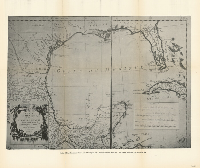
[Section of] Carte du Mexique et de la Nouvelle Espagne
1779
Size: 14.0 x 16.7 inches
97485
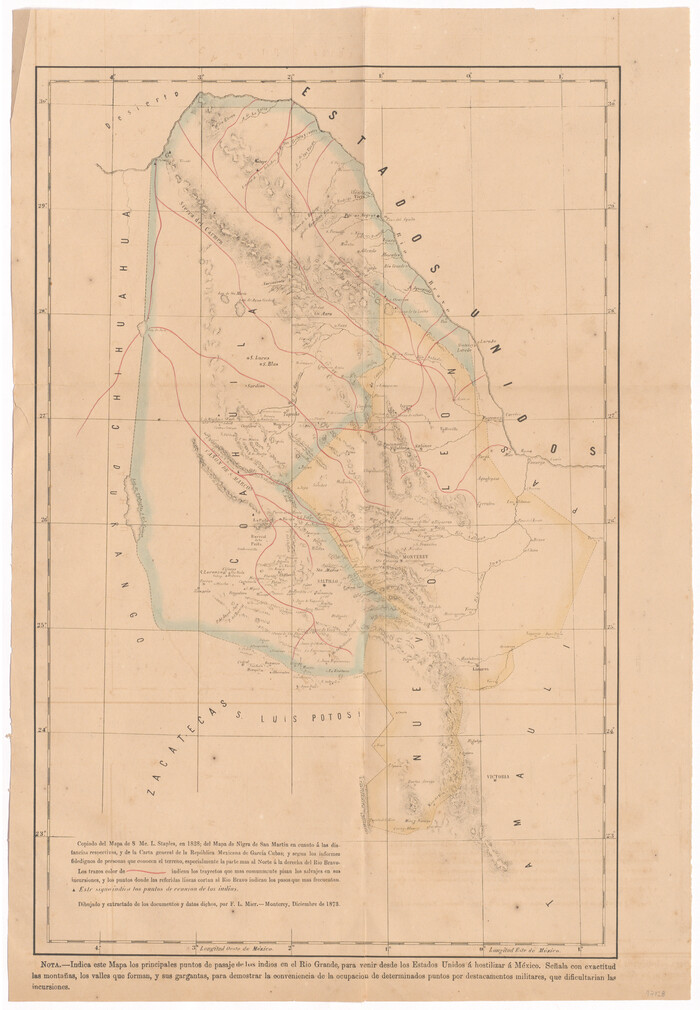
[Map of Coahuila and Nuevo Leon]
Print $20.00
- Digital $50.00
[Map of Coahuila and Nuevo Leon]
1873
Size: 16.8 x 11.6 inches
97128


Visitor's Guide to the Aztec World

Visitor's Guide to the Aztec World
1980
Size: 20.3 x 25.9 inches
96833
Vias de Comunicacion y Movimiento Maritimo

Print $20.00
- Digital $50.00
Vias de Comunicacion y Movimiento Maritimo
Size: 26.1 x 34.2 inches
96800


The United States of Mexico

Print $20.00
- Digital $50.00
The United States of Mexico
1832
Size: 15.4 x 12.8 inches
93952
The Principal Transportation Lines west of Chicago, St. Louis, & New Orleans, to accompany the report on the Internal Commerce of the United States for 1880

Print $20.00
- Digital $50.00
The Principal Transportation Lines west of Chicago, St. Louis, & New Orleans, to accompany the report on the Internal Commerce of the United States for 1880
1880
Size: 26.7 x 22.7 inches
95906
The North Part of America Conteyning Newfoundland, New England, Virginia, Florida, New Spaine, and Nova Francia

Print $20.00
- Digital $50.00
The North Part of America Conteyning Newfoundland, New England, Virginia, Florida, New Spaine, and Nova Francia
1625
Size: 12.6 x 16.2 inches
97028

The Great European Alliance against the Mexican Republic

Print $20.00
- Digital $50.00
The Great European Alliance against the Mexican Republic
1861
Size: 22.9 x 16.2 inches
96429
The Dividing Link - Mexico & Central America

The Dividing Link - Mexico & Central America
Size: 20.5 x 31.2 inches
95941
The Continent and Islands of the West Indies

Print $20.00
The Continent and Islands of the West Indies
1804
Size: 22.8 x 26.0 inches
79318
The Coast of New Spain from Neuva Vera Cruz to Triste Island

Print $20.00
- Digital $50.00
The Coast of New Spain from Neuva Vera Cruz to Triste Island
1775
Size: 21.0 x 28.9 inches
95919
The Coast of Mexico from Laguna de Esmotes to Punta Brava

Print $20.00
- Digital $50.00
The Coast of Mexico from Laguna de Esmotes to Punta Brava
1775
Size: 22.2 x 29.8 inches
95920
Texas, Mexico and part of the United States compiled from the latest and best authorities

Print $20.00
- Digital $50.00
Texas, Mexico and part of the United States compiled from the latest and best authorities
1836
Size: 9.1 x 11.0 inches
95958
Territorios de Sierragorda e Isla del Carmen

Print $20.00
- Digital $50.00
Territorios de Sierragorda e Isla del Carmen
Size: 22.9 x 31.2 inches
97011

Tanner's Travelling Map of Mexico

Print $2.00
- Digital $50.00
Tanner's Travelling Map of Mexico
1847
Size: 6.2 x 4.1 inches
93877


Survey of the Mexican Lines of Defence at Cerro Gordo, and the lines of attack of the American Army under Major General Scott, on the 17th and 18th of April, 1847

Print $20.00
- Digital $50.00
Survey of the Mexican Lines of Defence at Cerro Gordo, and the lines of attack of the American Army under Major General Scott, on the 17th and 18th of April, 1847
1847
Size: 15.3 x 21.6 inches
95830
[Untitled Map of Baja California & West Coast of Mexico]
Print $20.00
- Digital $50.00
[Untitled Map of Baja California & West Coast of Mexico]
1541
-
Size
11.1 x 16.7 inches
-
Map/Doc
97353
-
Creation Date
1541
[Section of] Carte du Mexique et de la Nouvelle Espagne
[Section of] Carte du Mexique et de la Nouvelle Espagne
1779
-
Size
14.0 x 16.7 inches
-
Map/Doc
97485
-
Creation Date
1779
[Map of Coahuila and Nuevo Leon]
Print $20.00
- Digital $50.00
[Map of Coahuila and Nuevo Leon]
1873
-
Size
16.8 x 11.6 inches
-
Map/Doc
97128
-
Creation Date
1873
Visitor's Guide to the Aztec World
Visitor's Guide to the Aztec World
1980
-
Size
20.3 x 25.9 inches
-
Map/Doc
96833
-
Creation Date
1980
Vias de Comunicacion y Movimiento Maritimo
Print $20.00
- Digital $50.00
Vias de Comunicacion y Movimiento Maritimo
-
Size
26.1 x 34.2 inches
-
Map/Doc
96800
The United States of Mexico
Print $20.00
- Digital $50.00
The United States of Mexico
1832
-
Size
15.4 x 12.8 inches
-
Map/Doc
93952
-
Creation Date
1832
The Principal Transportation Lines west of Chicago, St. Louis, & New Orleans, to accompany the report on the Internal Commerce of the United States for 1880
Print $20.00
- Digital $50.00
The Principal Transportation Lines west of Chicago, St. Louis, & New Orleans, to accompany the report on the Internal Commerce of the United States for 1880
1880
-
Size
26.7 x 22.7 inches
-
Map/Doc
95906
-
Creation Date
1880
The North Part of America Conteyning Newfoundland, New England, Virginia, Florida, New Spaine, and Nova Francia
Print $20.00
- Digital $50.00
The North Part of America Conteyning Newfoundland, New England, Virginia, Florida, New Spaine, and Nova Francia
1625
-
Size
12.6 x 16.2 inches
-
Map/Doc
97028
-
Creation Date
1625
The Great European Alliance against the Mexican Republic
Print $20.00
- Digital $50.00
The Great European Alliance against the Mexican Republic
1861
-
Size
22.9 x 16.2 inches
-
Map/Doc
96429
-
Creation Date
1861
The Dividing Link - Mexico & Central America
The Dividing Link - Mexico & Central America
-
Size
20.5 x 31.2 inches
-
Map/Doc
95941
The Continent and Islands of the West Indies
Print $20.00
The Continent and Islands of the West Indies
1804
-
Size
22.8 x 26.0 inches
-
Map/Doc
79318
-
Creation Date
1804
The Coast of New Spain from Neuva Vera Cruz to Triste Island
Print $20.00
- Digital $50.00
The Coast of New Spain from Neuva Vera Cruz to Triste Island
1775
-
Size
21.0 x 28.9 inches
-
Map/Doc
95919
-
Creation Date
1775
The Coast of Mexico from Laguna de Esmotes to Punta Brava
Print $20.00
- Digital $50.00
The Coast of Mexico from Laguna de Esmotes to Punta Brava
1775
-
Size
22.2 x 29.8 inches
-
Map/Doc
95920
-
Creation Date
1775
Texas, Mexico and part of the United States compiled from the latest and best authorities
Print $20.00
- Digital $50.00
Texas, Mexico and part of the United States compiled from the latest and best authorities
1836
-
Size
9.1 x 11.0 inches
-
Map/Doc
95958
-
Creation Date
1836
Territorios de Sierragorda e Isla del Carmen
Print $20.00
- Digital $50.00
Territorios de Sierragorda e Isla del Carmen
-
Size
22.9 x 31.2 inches
-
Map/Doc
97011
Temistitan

Print $20.00
- Digital $50.00
Temistitan
1556
-
Size
12.9 x 8.8 inches
-
Map/Doc
95950
-
Creation Date
1556
Tanner's Travelling Map of Mexico
Print $2.00
- Digital $50.00
Tanner's Travelling Map of Mexico
1847
-
Size
6.2 x 4.1 inches
-
Map/Doc
93877
-
Creation Date
1847
Survey of the Mexican Lines of Defence at Cerro Gordo, and the lines of attack of the American Army under Major General Scott, on the 17th and 18th of April, 1847
Print $20.00
- Digital $50.00
Survey of the Mexican Lines of Defence at Cerro Gordo, and the lines of attack of the American Army under Major General Scott, on the 17th and 18th of April, 1847
1847
-
Size
15.3 x 21.6 inches
-
Map/Doc
95830
-
Creation Date
1847