A Correct Map of the Seat of War in Mexico

Print $20.00
A Correct Map of the Seat of War in Mexico
1847
Size: 28.3 x 21.1 inches
79725
A Correct Map of the Seat of War in Mexico Being a Copy of Genl Arista's Map, taken at Resaca de la Palma, with additions and Corrections

Print $20.00
- Digital $50.00
A Correct Map of the Seat of War in Mexico Being a Copy of Genl Arista's Map, taken at Resaca de la Palma, with additions and Corrections
1847
Size: 30.7 x 22.5 inches
93962
A Map of Louisiana and Mexico

Print $20.00
A Map of Louisiana and Mexico
1820
Size: 43.0 x 32.6 inches
76218
A Map of Louisiana and Mexico

Print $20.00
- Digital $50.00
A Map of Louisiana and Mexico
1820
Size: 43.8 x 32.9 inches
94945
A Map of Mexico, Louisiana and the Missouri Territory, including also the State of Mississippi, Alabama Territory, East & West Florida, Georgia, South Carolina & part of the Island of Cuba

Print $40.00
A Map of Mexico, Louisiana and the Missouri Territory, including also the State of Mississippi, Alabama Territory, East & West Florida, Georgia, South Carolina & part of the Island of Cuba
Size: 66.9 x 64.2 inches
95312
A Map of the Internal Provinces of New Spain

Print $20.00
A Map of the Internal Provinces of New Spain
1807
Size: 18.9 x 19.5 inches
76234
A Map of the Internal Provinces of New Spain

Print $20.00
- Digital $50.00
A Map of the Internal Provinces of New Spain
1807
Size: 20.9 x 20.0 inches
97239
A Map of the United States of Mexico as organized and defined by the several Acts of the Congress of that Republic

Print $20.00
A Map of the United States of Mexico as organized and defined by the several Acts of the Congress of that Republic
1826
Size: 23.2 x 28.9 inches
93635
A Map of the United States of Mexico as organized and defined by the several Acts of the Congress of that Republic

Print $20.00
- Digital $50.00
A Map of the United States of Mexico as organized and defined by the several Acts of the Congress of that Republic
1846
Size: 24.0 x 31.7 inches
93760
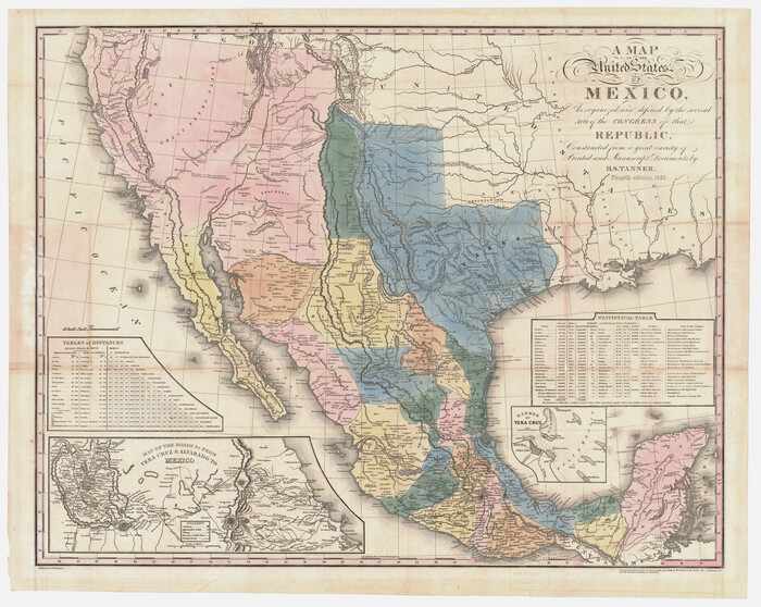
A Map of the United States of Mexico as organized and defined by the several Acts of the Congress of that Republic

Print $20.00
- Digital $50.00
A Map of the United States of Mexico as organized and defined by the several Acts of the Congress of that Republic
1847
Size: 24.3 x 30.6 inches
93876
A Map of the United States of Mexico as organized and defined by the several Acts of the Congress of that Republic

Print $20.00
- Digital $50.00
A Map of the United States of Mexico as organized and defined by the several Acts of the Congress of that Republic
1826
Size: 23.9 x 31.2 inches
93939
A Map of the United States of Mexico as organized and defined by the several Acts of the Congress of that Republic
Print $20.00
- Digital $50.00
A Map of the United States of Mexico as organized and defined by the several Acts of the Congress of that Republic
1847
Size: 25.3 x 31.8 inches
95913
A Map of the West-Indies & c., Mexico or New Spain. Also ye trade winds and ye several tracts made by ye Galeons and Flota from place to place

Print $20.00
- Digital $50.00
A Map of the West-Indies & c., Mexico or New Spain. Also ye trade winds and ye several tracts made by ye Galeons and Flota from place to place
1729
Size: 9.5 x 13.6 inches
94087


Atlas Geográfico, Estadístico é Histórico de la República Mexicana

Atlas Geográfico, Estadístico é Histórico de la República Mexicana
95689
Atlas Pintoresco e Historico de los Estados Unidos Mexicanos

Atlas Pintoresco e Historico de los Estados Unidos Mexicanos
96796

Carta Eclesiastica

Print $20.00
- Digital $50.00
Carta Eclesiastica
1897
Size: 26.1 x 34.1 inches
96799
Carta Esferica Del Reyno De Mexico y parte de la America Setentrional, Para inteligencia de la Obra intitulada: Descubrimiento y Conquista de la America

Print $20.00
- Digital $50.00
Carta Esferica Del Reyno De Mexico y parte de la America Setentrional, Para inteligencia de la Obra intitulada: Descubrimiento y Conquista de la America
1802
Size: 15.1 x 20.5 inches
97410
Carta Etnografica

Print $20.00
- Digital $50.00
Carta Etnografica
1897
Size: 26.2 x 34.1 inches
96798
Carta General de la Republica Mexicana

Print $20.00
- Digital $50.00
Carta General de la Republica Mexicana
Size: 23.1 x 31.1 inches
96983
Carta General de la República Mexicana Formada en vista de los datos mas recientes y exactos que se han reunido con tal objeto, y constan en la noticia presentada al Exmo. Sr. Ministro de Fomento, por Antonio García y Cubas

Print $20.00
- Digital $50.00
Carta General de la República Mexicana Formada en vista de los datos mas recientes y exactos que se han reunido con tal objeto, y constan en la noticia presentada al Exmo. Sr. Ministro de Fomento, por Antonio García y Cubas
Size: 23.3 x 29.2 inches
95824
Carta General de la República Mexicana Formada para el estudio de la configuracion y division interior de su territorio

Print $20.00
- Digital $50.00
Carta General de la República Mexicana Formada para el estudio de la configuracion y division interior de su territorio
Size: 23.2 x 29.4 inches
95823
Carta General de la República Mexicana formada por Antonio García y Cubas

Print $40.00
Carta General de la República Mexicana formada por Antonio García y Cubas
1863
Size: 48.7 x 57.1 inches
95307
Carta Geografica General de la Republica Mexicana

Print $40.00
- Digital $50.00
Carta Geografica General de la Republica Mexicana
1845
Size: 38.1 x 52.9 inches
96438
Carta Hidrografica

Print $20.00
- Digital $50.00
Carta Hidrografica
1897
Size: 26.0 x 34.3 inches
96803
Carta Historica y Arqueologica

Print $20.00
- Digital $50.00
Carta Historica y Arqueologica
Size: 26.0 x 34.4 inches
96806
A Correct Map of the Seat of War in Mexico
Print $20.00
A Correct Map of the Seat of War in Mexico
1847
-
Size
28.3 x 21.1 inches
-
Map/Doc
79725
-
Creation Date
1847
A Correct Map of the Seat of War in Mexico Being a Copy of Genl Arista's Map, taken at Resaca de la Palma, with additions and Corrections
Print $20.00
- Digital $50.00
A Correct Map of the Seat of War in Mexico Being a Copy of Genl Arista's Map, taken at Resaca de la Palma, with additions and Corrections
1847
-
Size
30.7 x 22.5 inches
-
Map/Doc
93962
-
Creation Date
1847
A Map of Louisiana and Mexico
Print $20.00
A Map of Louisiana and Mexico
1820
-
Size
43.0 x 32.6 inches
-
Map/Doc
76218
-
Creation Date
1820
A Map of Louisiana and Mexico
Print $20.00
- Digital $50.00
A Map of Louisiana and Mexico
1820
-
Size
43.8 x 32.9 inches
-
Map/Doc
94945
-
Creation Date
1820
A Map of Mexico, Louisiana and the Missouri Territory, including also the State of Mississippi, Alabama Territory, East & West Florida, Georgia, South Carolina & part of the Island of Cuba
Print $40.00
A Map of Mexico, Louisiana and the Missouri Territory, including also the State of Mississippi, Alabama Territory, East & West Florida, Georgia, South Carolina & part of the Island of Cuba
-
Size
66.9 x 64.2 inches
-
Map/Doc
95312
A Map of the Internal Provinces of New Spain
Print $20.00
A Map of the Internal Provinces of New Spain
1807
-
Size
18.9 x 19.5 inches
-
Map/Doc
76234
-
Creation Date
1807
A Map of the Internal Provinces of New Spain
Print $20.00
- Digital $50.00
A Map of the Internal Provinces of New Spain
1807
-
Size
20.9 x 20.0 inches
-
Map/Doc
97239
-
Creation Date
1807
A Map of the United States of Mexico as organized and defined by the several Acts of the Congress of that Republic
Print $20.00
A Map of the United States of Mexico as organized and defined by the several Acts of the Congress of that Republic
1826
-
Size
23.2 x 28.9 inches
-
Map/Doc
93635
-
Creation Date
1826
A Map of the United States of Mexico as organized and defined by the several Acts of the Congress of that Republic
Print $20.00
- Digital $50.00
A Map of the United States of Mexico as organized and defined by the several Acts of the Congress of that Republic
1846
-
Size
24.0 x 31.7 inches
-
Map/Doc
93760
-
Creation Date
1846
A Map of the United States of Mexico as organized and defined by the several Acts of the Congress of that Republic
Print $20.00
- Digital $50.00
A Map of the United States of Mexico as organized and defined by the several Acts of the Congress of that Republic
1847
-
Size
24.3 x 30.6 inches
-
Map/Doc
93876
-
Creation Date
1847
A Map of the United States of Mexico as organized and defined by the several Acts of the Congress of that Republic
Print $20.00
- Digital $50.00
A Map of the United States of Mexico as organized and defined by the several Acts of the Congress of that Republic
1826
-
Size
23.9 x 31.2 inches
-
Map/Doc
93939
-
Creation Date
1826
A Map of the United States of Mexico as organized and defined by the several Acts of the Congress of that Republic
Print $20.00
- Digital $50.00
A Map of the United States of Mexico as organized and defined by the several Acts of the Congress of that Republic
1847
-
Size
25.3 x 31.8 inches
-
Map/Doc
95913
-
Creation Date
1847
A Map of the West-Indies & c., Mexico or New Spain. Also ye trade winds and ye several tracts made by ye Galeons and Flota from place to place
Print $20.00
- Digital $50.00
A Map of the West-Indies & c., Mexico or New Spain. Also ye trade winds and ye several tracts made by ye Galeons and Flota from place to place
1729
-
Size
9.5 x 13.6 inches
-
Map/Doc
94087
-
Creation Date
1729
Ancien Mexico

Print $20.00
- Digital $50.00
Ancien Mexico
1753
-
Size
9.9 x 13.6 inches
-
Map/Doc
97082
-
Creation Date
1753
Atlas Geográfico, Estadístico é Histórico de la República Mexicana
Atlas Geográfico, Estadístico é Histórico de la República Mexicana
-
Map/Doc
95689
Atlas Pintoresco e Historico de los Estados Unidos Mexicanos
Atlas Pintoresco e Historico de los Estados Unidos Mexicanos
-
Map/Doc
96796
Carta Agricola

Print $20.00
- Digital $50.00
Carta Agricola
1897
-
Size
26.0 x 34.3 inches
-
Map/Doc
96804
-
Creation Date
1897
Carta Eclesiastica
Print $20.00
- Digital $50.00
Carta Eclesiastica
1897
-
Size
26.1 x 34.1 inches
-
Map/Doc
96799
-
Creation Date
1897
Carta Esferica Del Reyno De Mexico y parte de la America Setentrional, Para inteligencia de la Obra intitulada: Descubrimiento y Conquista de la America
Print $20.00
- Digital $50.00
Carta Esferica Del Reyno De Mexico y parte de la America Setentrional, Para inteligencia de la Obra intitulada: Descubrimiento y Conquista de la America
1802
-
Size
15.1 x 20.5 inches
-
Map/Doc
97410
-
Creation Date
1802
Carta Etnografica
Print $20.00
- Digital $50.00
Carta Etnografica
1897
-
Size
26.2 x 34.1 inches
-
Map/Doc
96798
-
Creation Date
1897
Carta General de la Republica Mexicana
Print $20.00
- Digital $50.00
Carta General de la Republica Mexicana
-
Size
23.1 x 31.1 inches
-
Map/Doc
96983
Carta General de la República Mexicana Formada en vista de los datos mas recientes y exactos que se han reunido con tal objeto, y constan en la noticia presentada al Exmo. Sr. Ministro de Fomento, por Antonio García y Cubas
Print $20.00
- Digital $50.00
Carta General de la República Mexicana Formada en vista de los datos mas recientes y exactos que se han reunido con tal objeto, y constan en la noticia presentada al Exmo. Sr. Ministro de Fomento, por Antonio García y Cubas
-
Size
23.3 x 29.2 inches
-
Map/Doc
95824
Carta General de la República Mexicana Formada para el estudio de la configuracion y division interior de su territorio
Print $20.00
- Digital $50.00
Carta General de la República Mexicana Formada para el estudio de la configuracion y division interior de su territorio
-
Size
23.2 x 29.4 inches
-
Map/Doc
95823
Carta General de la República Mexicana formada por Antonio García y Cubas
Print $40.00
Carta General de la República Mexicana formada por Antonio García y Cubas
1863
-
Size
48.7 x 57.1 inches
-
Map/Doc
95307
-
Creation Date
1863
Carta Geografica General de la Republica Mexicana
Print $40.00
- Digital $50.00
Carta Geografica General de la Republica Mexicana
1845
-
Size
38.1 x 52.9 inches
-
Map/Doc
96438
-
Creation Date
1845
Carta Hidrografica
Print $20.00
- Digital $50.00
Carta Hidrografica
1897
-
Size
26.0 x 34.3 inches
-
Map/Doc
96803
-
Creation Date
1897
Carta Historica y Arqueologica
Print $20.00
- Digital $50.00
Carta Historica y Arqueologica
-
Size
26.0 x 34.4 inches
-
Map/Doc
96806