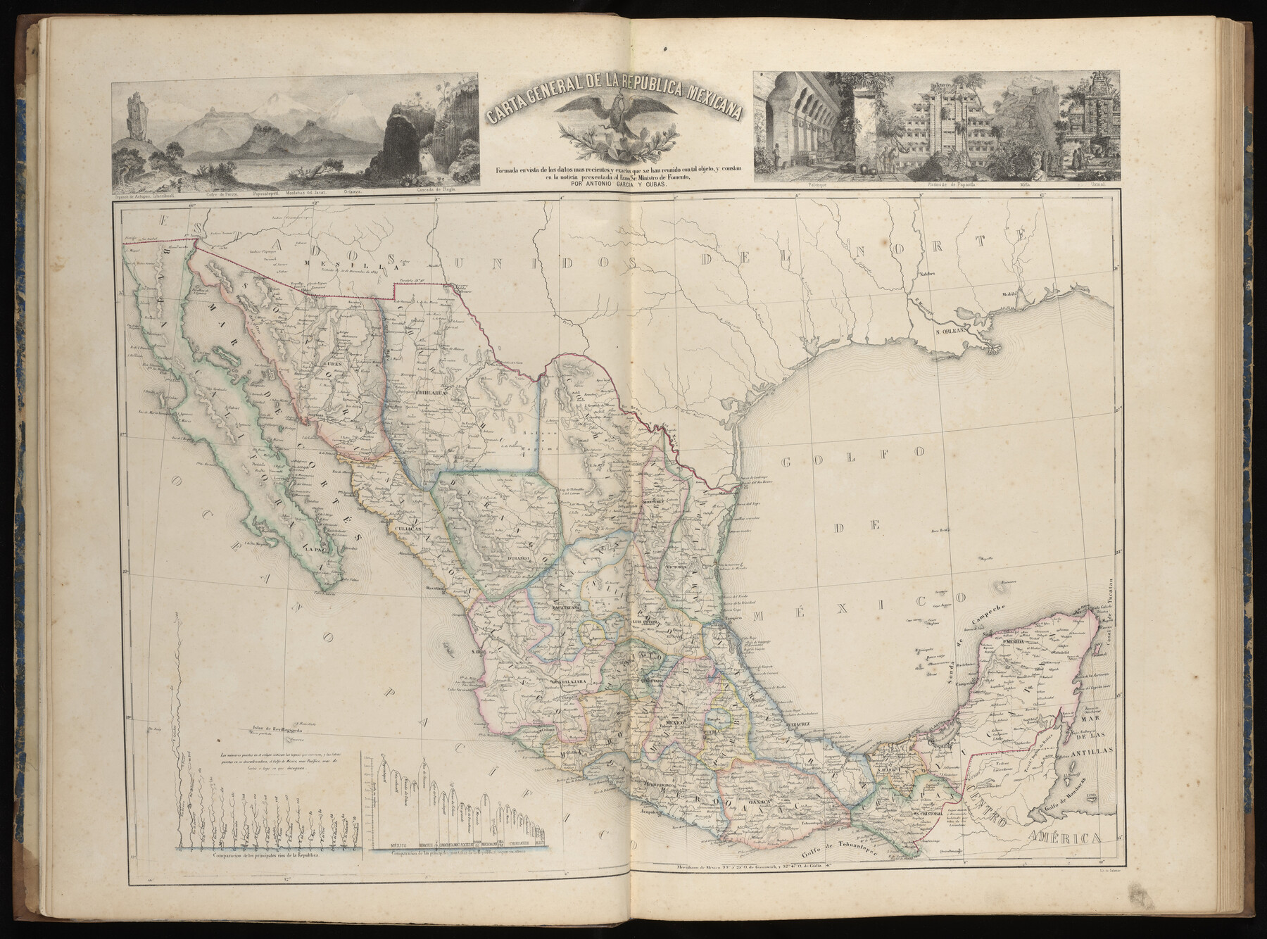
Carta General de la Republica Mexicana
-
Map/Doc
96983
-
Collection
General Map Collection
-
Object Dates
1858 (Publication Date)
-
People and Organizations
Antonio García y Cubas (Cartographer)
-
Subjects
Atlas Mexico
-
Height x Width
23.1 x 31.1 inches
58.7 x 79.0 cm
-
Medium
paper, etching/engraving/lithograph
-
Comments
Map 2 of 32 from "Atlas Geografico, Estadistico e Historico de la Republica Mexicana" (95689)
Related maps
Atlas Geográfico, Estadístico é Histórico de la República Mexicana

Atlas Geográfico, Estadístico é Histórico de la República Mexicana
Map/Doc 95689
Part of: General Map Collection
Crosby County Sketch File 1b

Print $20.00
- Digital $50.00
Crosby County Sketch File 1b
Size 18.0 x 14.5 inches
Map/Doc 11244
Midland County Sketch File 9

Print $20.00
- Digital $50.00
Midland County Sketch File 9
Size 19.7 x 29.2 inches
Map/Doc 12085
Flight Mission No. DQN-2K, Frame 37, Calhoun County

Print $20.00
- Digital $50.00
Flight Mission No. DQN-2K, Frame 37, Calhoun County
1953
Size 18.4 x 22.2 inches
Map/Doc 84242
Kinney County Working Sketch 38

Print $20.00
- Digital $50.00
Kinney County Working Sketch 38
1971
Size 28.9 x 30.6 inches
Map/Doc 70220
Wise County Sketch File 34

Print $6.00
- Digital $50.00
Wise County Sketch File 34
1856
Size 6.3 x 9.6 inches
Map/Doc 40592
Tom Green County Sketch File 35

Print $6.00
- Digital $50.00
Tom Green County Sketch File 35
Size 10.2 x 15.9 inches
Map/Doc 38192
Polk County Working Sketch 24

Print $20.00
- Digital $50.00
Polk County Working Sketch 24
1957
Size 24.8 x 25.3 inches
Map/Doc 71640
Limestone County Sketch File 1

Print $4.00
- Digital $50.00
Limestone County Sketch File 1
Size 9.8 x 8.1 inches
Map/Doc 30155
Falls County Sketch File 24

Print $4.00
- Digital $50.00
Falls County Sketch File 24
1859
Size 13.1 x 8.2 inches
Map/Doc 22428
Kinney County Working Sketch 34

Print $20.00
- Digital $50.00
Kinney County Working Sketch 34
1963
Size 23.0 x 26.9 inches
Map/Doc 70216
Erath County Working Sketch 15

Print $20.00
- Digital $50.00
Erath County Working Sketch 15
1961
Size 19.8 x 15.4 inches
Map/Doc 69096
Hardin County Sketch File 69

Print $20.00
- Digital $50.00
Hardin County Sketch File 69
1944
Size 25.1 x 22.0 inches
Map/Doc 11641
You may also like
Hays County Working Sketch 7

Print $20.00
- Digital $50.00
Hays County Working Sketch 7
1941
Size 16.3 x 16.2 inches
Map/Doc 66081
Flight Mission No. DAH-9M, Frame 197, Orange County

Print $20.00
- Digital $50.00
Flight Mission No. DAH-9M, Frame 197, Orange County
1953
Size 18.5 x 22.4 inches
Map/Doc 86865
El Nuevo México y Tierras Adyacentes Levantado para la Demarcación de los Límites de los Dominios Españoles y de los Estados Unidos

El Nuevo México y Tierras Adyacentes Levantado para la Demarcación de los Límites de los Dominios Españoles y de los Estados Unidos
1811
Size 9.4 x 12.6 inches
Map/Doc 94445
Flight Mission No. DAG-14K, Frame 140, Matagorda County

Print $20.00
- Digital $50.00
Flight Mission No. DAG-14K, Frame 140, Matagorda County
1952
Size 17.6 x 17.6 inches
Map/Doc 86307
Map of Duval County

Print $40.00
- Digital $50.00
Map of Duval County
1890
Size 69.8 x 43.8 inches
Map/Doc 4936
Energy Map of Texas Ornament

Price $20.00
Energy Map of Texas Ornament
2021
Size 2.5 x 2.5 inches
Map/Doc 96574
Mason County Sketch File 22

Print $8.00
- Digital $50.00
Mason County Sketch File 22
1932
Size 11.1 x 8.9 inches
Map/Doc 30719
[Block 1, Section 31]
![92171, [Block 1, Section 31], Twichell Survey Records](https://historictexasmaps.com/wmedia_w700/maps/92171-1.tif.jpg)
Print $20.00
- Digital $50.00
[Block 1, Section 31]
1946
Size 24.3 x 19.7 inches
Map/Doc 92171
Maps of Gulf Intracoastal Waterway, Texas - Sabine River to the Rio Grande and connecting waterways including ship channels

Print $20.00
- Digital $50.00
Maps of Gulf Intracoastal Waterway, Texas - Sabine River to the Rio Grande and connecting waterways including ship channels
1966
Size 14.5 x 22.4 inches
Map/Doc 61951
Coryell County Working Sketch 29

Print $40.00
- Digital $50.00
Coryell County Working Sketch 29
1999
Size 35.3 x 67.8 inches
Map/Doc 68236
Galveston Bay and Approaches

Print $40.00
- Digital $50.00
Galveston Bay and Approaches
1982
Size 51.4 x 37.0 inches
Map/Doc 69885
Wilbarger County Rolled Sketch 10

Print $20.00
- Digital $50.00
Wilbarger County Rolled Sketch 10
1983
Size 37.6 x 23.8 inches
Map/Doc 8259