Maps & Lists Showing Prison Lands (Oil & Gas) Leased as of June 1955

Digital $50.00
Maps & Lists Showing Prison Lands (Oil & Gas) Leased as of June 1955
Size: 11.4 x 7.3 inches
62868
Maps & Lists Showing Prison Lands (Oil & Gas) Leased as of June 1955

Digital $50.00
Maps & Lists Showing Prison Lands (Oil & Gas) Leased as of June 1955
Size: 11.2 x 8.9 inches
62875
State Prison Lands in Walker County - Wynne Farm, Goree Farm, Dairy Pasture, Cemetery Tract

Print $20.00
- Digital $50.00
State Prison Lands in Walker County - Wynne Farm, Goree Farm, Dairy Pasture, Cemetery Tract
Size: 16.9 x 19.1 inches
62994
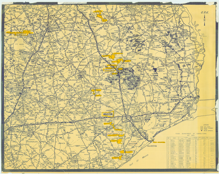
[Texas Department of Corrections Prison Farm Locations]
Print $40.00
- Digital $50.00
[Texas Department of Corrections Prison Farm Locations]
Size: 43.0 x 54.0 inches
78638
Prison Property, Walker Co.

Print $20.00
- Digital $50.00
Prison Property, Walker Co.
Size: 19.3 x 20.2 inches
94278
Prison Property, Walker County

Print $20.00
- Digital $50.00
Prison Property, Walker County
Size: 32.6 x 22.7 inches
94279
Prison Property, Walker County

Print $20.00
- Digital $50.00
Prison Property, Walker County
Size: 16.3 x 15.9 inches
94280
Northwest Section of Ramsey State Farm

Print $20.00
- Digital $50.00
Northwest Section of Ramsey State Farm
Size: 12.6 x 17.2 inches
94281
Prison Property, Walker Co.

Print $20.00
- Digital $50.00
Prison Property, Walker Co.
Size: 34.2 x 24.7 inches
94283
Brazos River, Clemens State Farm Sheet

Print $20.00
- Digital $50.00
Brazos River, Clemens State Farm Sheet
1915
Size: 37.5 x 34.6 inches
69673
Brazos River, Sketch Map of Imperial and Harlem State Prison Farms, Fort Bend County Texas Showing Tentative Plan of Reclamation

Print $20.00
- Digital $50.00
Brazos River, Sketch Map of Imperial and Harlem State Prison Farms, Fort Bend County Texas Showing Tentative Plan of Reclamation
1929
Size: 25.6 x 25.6 inches
69681
Brazos River, Harlem-Imperial Farms Project

Print $20.00
- Digital $50.00
Brazos River, Harlem-Imperial Farms Project
1930
Size: 28.3 x 25.5 inches
69678
Fort Bend County Rolled Sketch T

Print $20.00
- Digital $50.00
Fort Bend County Rolled Sketch T
1930
Size: 28.7 x 25.8 inches
5908
Brazos River, Darrington-Ramsey Farms Project

Print $20.00
- Digital $50.00
Brazos River, Darrington-Ramsey Farms Project
1930
Size: 37.5 x 26.8 inches
69677
Brazos River, Harlem-Imperial Farms Project

Print $4.00
- Digital $50.00
Brazos River, Harlem-Imperial Farms Project
1931
Size: 29.4 x 26.6 inches
65285
State Prison Lands Transferred to A&M College, Forest Division, Cherokee County

Print $4.00
- Digital $50.00
State Prison Lands Transferred to A&M College, Forest Division, Cherokee County
1932
Size: 11.1 x 20.1 inches
65086
Ramsey State Farm of the Texas Prison System, Brazoria County

Print $4.00
- Digital $50.00
Ramsey State Farm of the Texas Prison System, Brazoria County
1932
Size: 15.9 x 18.6 inches
65273
Clemens Farm, State Prison System, Brazoria County

Print $4.00
- Digital $50.00
Clemens Farm, State Prison System, Brazoria County
1932
Size: 14.2 x 18.7 inches
65274
Map of Prison Properties in Vicinity of Huntsville, Walker County, Texas

Print $20.00
- Digital $50.00
Map of Prison Properties in Vicinity of Huntsville, Walker County, Texas
1933
Size: 36.6 x 43.0 inches
62992
Map showing location of Texas Prison Farms surveyed for the Texas Prison System

Print $20.00
- Digital $50.00
Map showing location of Texas Prison Farms surveyed for the Texas Prison System
1934
Size: 15.6 x 12.3 inches
94277
Map of Ramsey State Farm

Print $20.00
- Digital $50.00
Map of Ramsey State Farm
1934
Size: 30.3 x 38.0 inches
94284
Brazos River, Sugarland Sheet

Print $20.00
- Digital $50.00
Brazos River, Sugarland Sheet
1938
Size: 31.0 x 40.6 inches
65288
Plat of survey in the North West portion of the Ramsey State Farm

Print $20.00
- Digital $50.00
Plat of survey in the North West portion of the Ramsey State Farm
1942
Size: 25.9 x 30.4 inches
94282
Fort Bend County Rolled Sketch 5

Print $20.00
- Digital $50.00
Fort Bend County Rolled Sketch 5
1956
Size: 34.6 x 33.5 inches
5895
Fort Bend County Rolled Sketch 6

Print $20.00
- Digital $50.00
Fort Bend County Rolled Sketch 6
1956
Size: 39.6 x 34.8 inches
5896
Fort Bend County Rolled Sketch 4

Print $20.00
- Digital $50.00
Fort Bend County Rolled Sketch 4
1956
Size: 30.1 x 43.8 inches
5894
Current Miscellaneous File 63

Print $6.00
- Digital $50.00
Current Miscellaneous File 63
1957
Size: 14.1 x 8.8 inches
74100
Fort Bend County Rolled Sketch 10

Print $99.00
- Digital $50.00
Fort Bend County Rolled Sketch 10
1958
Size: 9.9 x 15.9 inches
44707
Fort Bend County Rolled Sketch 3

Print $20.00
- Digital $50.00
Fort Bend County Rolled Sketch 3
1958
Size: 31.4 x 31.5 inches
5893
Maps & Lists Showing Prison Lands (Oil & Gas) Leased as of June 1955
Digital $50.00
Maps & Lists Showing Prison Lands (Oil & Gas) Leased as of June 1955
-
Size
11.4 x 7.3 inches
-
Map/Doc
62868
Maps & Lists Showing Prison Lands (Oil & Gas) Leased as of June 1955
Digital $50.00
Maps & Lists Showing Prison Lands (Oil & Gas) Leased as of June 1955
-
Size
11.2 x 8.9 inches
-
Map/Doc
62875
State Prison Lands in Walker County - Wynne Farm, Goree Farm, Dairy Pasture, Cemetery Tract
Print $20.00
- Digital $50.00
State Prison Lands in Walker County - Wynne Farm, Goree Farm, Dairy Pasture, Cemetery Tract
-
Size
16.9 x 19.1 inches
-
Map/Doc
62994
[Texas Department of Corrections Prison Farm Locations]
Print $40.00
- Digital $50.00
[Texas Department of Corrections Prison Farm Locations]
-
Size
43.0 x 54.0 inches
-
Map/Doc
78638
Prison Property, Walker Co.
Print $20.00
- Digital $50.00
Prison Property, Walker Co.
-
Size
19.3 x 20.2 inches
-
Map/Doc
94278
Prison Property, Walker County
Print $20.00
- Digital $50.00
Prison Property, Walker County
-
Size
32.6 x 22.7 inches
-
Map/Doc
94279
Prison Property, Walker County
Print $20.00
- Digital $50.00
Prison Property, Walker County
-
Size
16.3 x 15.9 inches
-
Map/Doc
94280
Northwest Section of Ramsey State Farm
Print $20.00
- Digital $50.00
Northwest Section of Ramsey State Farm
-
Size
12.6 x 17.2 inches
-
Map/Doc
94281
Prison Property, Walker Co.
Print $20.00
- Digital $50.00
Prison Property, Walker Co.
-
Size
34.2 x 24.7 inches
-
Map/Doc
94283
Brazos River, Clemens State Farm Sheet
Print $20.00
- Digital $50.00
Brazos River, Clemens State Farm Sheet
1915
-
Size
37.5 x 34.6 inches
-
Map/Doc
69673
-
Creation Date
1915
Brazos River, Sketch Map of Imperial and Harlem State Prison Farms, Fort Bend County Texas Showing Tentative Plan of Reclamation
Print $20.00
- Digital $50.00
Brazos River, Sketch Map of Imperial and Harlem State Prison Farms, Fort Bend County Texas Showing Tentative Plan of Reclamation
1929
-
Size
25.6 x 25.6 inches
-
Map/Doc
69681
-
Creation Date
1929
Brazos River, Harlem-Imperial Farms Project
Print $20.00
- Digital $50.00
Brazos River, Harlem-Imperial Farms Project
1930
-
Size
28.3 x 25.5 inches
-
Map/Doc
69678
-
Creation Date
1930
Fort Bend County Rolled Sketch T
Print $20.00
- Digital $50.00
Fort Bend County Rolled Sketch T
1930
-
Size
28.7 x 25.8 inches
-
Map/Doc
5908
-
Creation Date
1930
Brazos River, Darrington-Ramsey Farms Project
Print $20.00
- Digital $50.00
Brazos River, Darrington-Ramsey Farms Project
1930
-
Size
37.5 x 26.8 inches
-
Map/Doc
69677
-
Creation Date
1930
Brazos River, Harlem-Imperial Farms Project
Print $4.00
- Digital $50.00
Brazos River, Harlem-Imperial Farms Project
1931
-
Size
29.4 x 26.6 inches
-
Map/Doc
65285
-
Creation Date
1931
State Prison Lands Transferred to A&M College, Forest Division, Cherokee County
Print $4.00
- Digital $50.00
State Prison Lands Transferred to A&M College, Forest Division, Cherokee County
1932
-
Size
11.1 x 20.1 inches
-
Map/Doc
65086
-
Creation Date
1932
Ramsey State Farm of the Texas Prison System, Brazoria County
Print $4.00
- Digital $50.00
Ramsey State Farm of the Texas Prison System, Brazoria County
1932
-
Size
15.9 x 18.6 inches
-
Map/Doc
65273
-
Creation Date
1932
Clemens Farm, State Prison System, Brazoria County
Print $4.00
- Digital $50.00
Clemens Farm, State Prison System, Brazoria County
1932
-
Size
14.2 x 18.7 inches
-
Map/Doc
65274
-
Creation Date
1932
Map of Prison Properties in Vicinity of Huntsville, Walker County, Texas
Print $20.00
- Digital $50.00
Map of Prison Properties in Vicinity of Huntsville, Walker County, Texas
1933
-
Size
36.6 x 43.0 inches
-
Map/Doc
62992
-
Creation Date
1933
Map showing location of Texas Prison Farms surveyed for the Texas Prison System
Print $20.00
- Digital $50.00
Map showing location of Texas Prison Farms surveyed for the Texas Prison System
1934
-
Size
15.6 x 12.3 inches
-
Map/Doc
94277
-
Creation Date
1934
Map of Ramsey State Farm
Print $20.00
- Digital $50.00
Map of Ramsey State Farm
1934
-
Size
30.3 x 38.0 inches
-
Map/Doc
94284
-
Creation Date
1934
Brazos River, Sugarland Sheet
Print $20.00
- Digital $50.00
Brazos River, Sugarland Sheet
1938
-
Size
31.0 x 40.6 inches
-
Map/Doc
65288
-
Creation Date
1938
Plat of survey in the North West portion of the Ramsey State Farm
Print $20.00
- Digital $50.00
Plat of survey in the North West portion of the Ramsey State Farm
1942
-
Size
25.9 x 30.4 inches
-
Map/Doc
94282
-
Creation Date
1942
Walker County

Print $20.00
- Digital $50.00
Walker County
1944
-
Size
45.7 x 38.4 inches
-
Map/Doc
73314
-
Creation Date
1944
Fort Bend County Rolled Sketch 5
Print $20.00
- Digital $50.00
Fort Bend County Rolled Sketch 5
1956
-
Size
34.6 x 33.5 inches
-
Map/Doc
5895
-
Creation Date
1956
Fort Bend County Rolled Sketch 6
Print $20.00
- Digital $50.00
Fort Bend County Rolled Sketch 6
1956
-
Size
39.6 x 34.8 inches
-
Map/Doc
5896
-
Creation Date
1956
Fort Bend County Rolled Sketch 4
Print $20.00
- Digital $50.00
Fort Bend County Rolled Sketch 4
1956
-
Size
30.1 x 43.8 inches
-
Map/Doc
5894
-
Creation Date
1956
Current Miscellaneous File 63
Print $6.00
- Digital $50.00
Current Miscellaneous File 63
1957
-
Size
14.1 x 8.8 inches
-
Map/Doc
74100
-
Creation Date
1957
Fort Bend County Rolled Sketch 10
Print $99.00
- Digital $50.00
Fort Bend County Rolled Sketch 10
1958
-
Size
9.9 x 15.9 inches
-
Map/Doc
44707
-
Creation Date
1958
Fort Bend County Rolled Sketch 3
Print $20.00
- Digital $50.00
Fort Bend County Rolled Sketch 3
1958
-
Size
31.4 x 31.5 inches
-
Map/Doc
5893
-
Creation Date
1958