Current Miscellaneous File 105

Print $18.00
- Digital $50.00
Current Miscellaneous File 105
Size: 8.8 x 14.2 inches
74680
A New Map of Texas, Oregon and California with the regions adjoining, compiled from the most recent authorities

Print $20.00
- Digital $50.00
A New Map of Texas, Oregon and California with the regions adjoining, compiled from the most recent authorities
Size: 22.8 x 20.9 inches
93990

Nouvelle carte du Mexique, du Texas et d'une partie des États Limitrophes

Print $20.00
- Digital $50.00
Nouvelle carte du Mexique, du Texas et d'une partie des États Limitrophes
1834
Size: 39.5 x 27.2 inches
93764
Nouvelle Carte du Mexique du Texas et d'une partie des états limitrophes

Print $20.00
- Digital $50.00
Nouvelle Carte du Mexique du Texas et d'une partie des états limitrophes
1834
Size: 39.9 x 27.4 inches
94098
Texas, Mexico and part of the United States compiled from the latest and best authorities

Print $20.00
- Digital $50.00
Texas, Mexico and part of the United States compiled from the latest and best authorities
1836
Size: 9.1 x 11.0 inches
95958
Trip to the West and Texas Comprising a Journey of Eight Thousand Miles, Through New-York, Michigan, Illinois, Missouri, Louisiana and Texas, in the Autumn and Winter of 1834-5. Interspersed with Anecdotes, Incidents and Observations. With a Brief Sketch

Trip to the West and Texas Comprising a Journey of Eight Thousand Miles, Through New-York, Michigan, Illinois, Missouri, Louisiana and Texas, in the Autumn and Winter of 1834-5. Interspersed with Anecdotes, Incidents and Observations. With a Brief Sketch
1836
97078
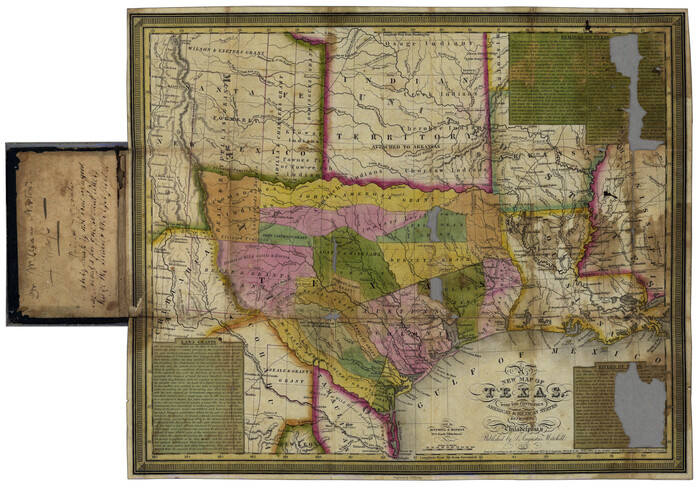
Map of Texas with Parts of the Adjoining States

Print $20.00
Map of Texas with Parts of the Adjoining States
1836
Size: 29.5 x 23.6 inches
76193
Map of Texas Containing the Latest Grants and Discoveries

Print $20.00
Map of Texas Containing the Latest Grants and Discoveries
1836
Size: 16.2 x 10.6 inches
76245
New Map of Texas with the Contiguous American and Mexican States
Print $20.00
- Digital $50.00
New Map of Texas with the Contiguous American and Mexican States
1836
Size: 13.7 x 19.7 inches
76795
Map of Texas containing the latest Grants and Discoveries

Print $20.00
- Digital $50.00
Map of Texas containing the latest Grants and Discoveries
1836
Size: 12.7 x 9.1 inches
93855
The History of Texas; or, the Emigrants, Farmer's, and Politician's Guide to the Character, Climate, Soil and Productions of that Country; geographically arranged from personal observation and experience.

Print $692.00
- Digital $50.00
The History of Texas; or, the Emigrants, Farmer's, and Politician's Guide to the Character, Climate, Soil and Productions of that Country; geographically arranged from personal observation and experience.
1836
Size: 8.1 x 5.3 inches
93856
Map of Texas With Parts of the Adjoining States

Print $20.00
- Digital $50.00
Map of Texas With Parts of the Adjoining States
1836
Size: 30.9 x 24.8 inches
93932
The History of Texas; or the Emigrant's, Farmer's, and Politician's Guide to the Character, Climate, Soil and Productions of that Country: Geographically Arranged from Personal Observation and Experience

The History of Texas; or the Emigrant's, Farmer's, and Politician's Guide to the Character, Climate, Soil and Productions of that Country: Geographically Arranged from Personal Observation and Experience
1836
Size: 7.6 x 9.1 inches
94038
Map of Texas containing the Latest Grants & Discoveries

Print $20.00
- Digital $50.00
Map of Texas containing the Latest Grants & Discoveries
1836
Size: 13.5 x 9.9 inches
94039
A New Map of Texas with the Contiguous American & Mexican States

Print $20.00
- Digital $50.00
A New Map of Texas with the Contiguous American & Mexican States
1837
Size: 12.5 x 15.1 inches
96643
Map of Texas with Parts of the Adjoining States

Print $20.00
- Digital $50.00
Map of Texas with Parts of the Adjoining States
1837
Size: 31.5 x 24.9 inches
2114
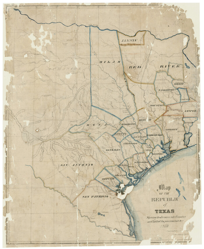
Map of the Republic of Texas Shewing [sic] its division into Counties and Latest Improvements to 1837
Print $20.00
- Digital $50.00
Map of the Republic of Texas Shewing [sic] its division into Counties and Latest Improvements to 1837
1837
Size: 28.2 x 23.0 inches
476
Map of the Republic of Texas showing its division into counties and latest improvements too

Print $20.00
- Digital $50.00
Map of the Republic of Texas showing its division into counties and latest improvements too
1837
Size: 12.3 x 9.6 inches
76874
Map of Texas With Parts of the Adjoining States

Print $20.00
Map of Texas With Parts of the Adjoining States
1837
Size: 29.9 x 25.2 inches
88998
Deputy Surveyors Field Note Book, San Patricio County

Deputy Surveyors Field Note Book, San Patricio County
1838
96675

Mexico & Guatimala with the Republic of Texas

Print $20.00
- Digital $50.00
Mexico & Guatimala with the Republic of Texas
1838
Size: 19.3 x 22.6 inches
94078
Map of Texas, compiled from surveys on record in the General Land Office of the Republic to the year 1839

Print $20.00
- Digital $50.00
Map of Texas, compiled from surveys on record in the General Land Office of the Republic to the year 1839
1839
Size: 33.1 x 25.8 inches
93986

Current Miscellaneous File 105
Print $18.00
- Digital $50.00
Current Miscellaneous File 105
-
Size
8.8 x 14.2 inches
-
Map/Doc
74680
A New Map of Texas, Oregon and California with the regions adjoining, compiled from the most recent authorities
Print $20.00
- Digital $50.00
A New Map of Texas, Oregon and California with the regions adjoining, compiled from the most recent authorities
-
Size
22.8 x 20.9 inches
-
Map/Doc
93990
Nouvelle carte du Mexique, du Texas et d'une partie des États Limitrophes
Print $20.00
- Digital $50.00
Nouvelle carte du Mexique, du Texas et d'une partie des États Limitrophes
1834
-
Size
39.5 x 27.2 inches
-
Map/Doc
93764
-
Creation Date
1834
Nouvelle Carte du Mexique du Texas et d'une partie des états limitrophes
Print $20.00
- Digital $50.00
Nouvelle Carte du Mexique du Texas et d'une partie des états limitrophes
1834
-
Size
39.9 x 27.4 inches
-
Map/Doc
94098
-
Creation Date
1834
Texas

Print $20.00
- Digital $50.00
Texas
1835
-
Size
10.6 x 13.3 inches
-
Map/Doc
95138
-
Creation Date
1835
Texas, Mexico and part of the United States compiled from the latest and best authorities
Print $20.00
- Digital $50.00
Texas, Mexico and part of the United States compiled from the latest and best authorities
1836
-
Size
9.1 x 11.0 inches
-
Map/Doc
95958
-
Creation Date
1836
Trip to the West and Texas Comprising a Journey of Eight Thousand Miles, Through New-York, Michigan, Illinois, Missouri, Louisiana and Texas, in the Autumn and Winter of 1834-5. Interspersed with Anecdotes, Incidents and Observations. With a Brief Sketch
Trip to the West and Texas Comprising a Journey of Eight Thousand Miles, Through New-York, Michigan, Illinois, Missouri, Louisiana and Texas, in the Autumn and Winter of 1834-5. Interspersed with Anecdotes, Incidents and Observations. With a Brief Sketch
1836
Second Edition
-
Map/Doc
97078
-
Creation Date
1836
Map of Texas with Parts of the Adjoining States
Print $20.00
Map of Texas with Parts of the Adjoining States
1836
-
Size
29.5 x 23.6 inches
-
Map/Doc
76193
-
Creation Date
1836
Map of Texas Containing the Latest Grants and Discoveries
Print $20.00
Map of Texas Containing the Latest Grants and Discoveries
1836
-
Size
16.2 x 10.6 inches
-
Map/Doc
76245
-
Creation Date
1836
New Map of Texas with the Contiguous American and Mexican States
Print $20.00
- Digital $50.00
New Map of Texas with the Contiguous American and Mexican States
1836
-
Size
13.7 x 19.7 inches
-
Map/Doc
76795
-
Creation Date
1836
Map of Texas containing the latest Grants and Discoveries
Print $20.00
- Digital $50.00
Map of Texas containing the latest Grants and Discoveries
1836
-
Size
12.7 x 9.1 inches
-
Map/Doc
93855
-
Creation Date
1836
The History of Texas; or, the Emigrants, Farmer's, and Politician's Guide to the Character, Climate, Soil and Productions of that Country; geographically arranged from personal observation and experience.
Print $692.00
- Digital $50.00
The History of Texas; or, the Emigrants, Farmer's, and Politician's Guide to the Character, Climate, Soil and Productions of that Country; geographically arranged from personal observation and experience.
1836
-
Size
8.1 x 5.3 inches
-
Map/Doc
93856
-
Creation Date
1836
Map of Texas With Parts of the Adjoining States
Print $20.00
- Digital $50.00
Map of Texas With Parts of the Adjoining States
1836
-
Size
30.9 x 24.8 inches
-
Map/Doc
93932
-
Creation Date
1836
The History of Texas; or the Emigrant's, Farmer's, and Politician's Guide to the Character, Climate, Soil and Productions of that Country: Geographically Arranged from Personal Observation and Experience
The History of Texas; or the Emigrant's, Farmer's, and Politician's Guide to the Character, Climate, Soil and Productions of that Country: Geographically Arranged from Personal Observation and Experience
1836
-
Size
7.6 x 9.1 inches
-
Map/Doc
94038
-
Creation Date
1836
Map of Texas containing the Latest Grants & Discoveries
Print $20.00
- Digital $50.00
Map of Texas containing the Latest Grants & Discoveries
1836
-
Size
13.5 x 9.9 inches
-
Map/Doc
94039
-
Creation Date
1836
Texas

Print $20.00
- Digital $50.00
Texas
1836
-
Size
9.0 x 11.1 inches
-
Map/Doc
97077
-
Creation Date
1836
A New Map of Texas with the Contiguous American & Mexican States
Print $20.00
- Digital $50.00
A New Map of Texas with the Contiguous American & Mexican States
1837
-
Size
12.5 x 15.1 inches
-
Map/Doc
96643
-
Creation Date
1837
Map of Texas with Parts of the Adjoining States
Print $20.00
- Digital $50.00
Map of Texas with Parts of the Adjoining States
1837
-
Size
31.5 x 24.9 inches
-
Map/Doc
2114
-
Creation Date
1837
Map of the Republic of Texas Shewing [sic] its division into Counties and Latest Improvements to 1837
Print $20.00
- Digital $50.00
Map of the Republic of Texas Shewing [sic] its division into Counties and Latest Improvements to 1837
1837
-
Size
28.2 x 23.0 inches
-
Map/Doc
476
-
Creation Date
1837
Map of the Republic of Texas showing its division into counties and latest improvements too
Print $20.00
- Digital $50.00
Map of the Republic of Texas showing its division into counties and latest improvements too
1837
-
Size
12.3 x 9.6 inches
-
Map/Doc
76874
-
Creation Date
1837
Map of Texas With Parts of the Adjoining States
Print $20.00
Map of Texas With Parts of the Adjoining States
1837
-
Size
29.9 x 25.2 inches
-
Map/Doc
88998
-
Creation Date
1837
Deputy Surveyors Field Note Book, San Patricio County
Deputy Surveyors Field Note Book, San Patricio County
1838
-
Map/Doc
96675
-
Creation Date
1838
Texas

Print $20.00
- Digital $50.00
Texas
1838
-
Size
17.4 x 13.8 inches
-
Map/Doc
93857
-
Creation Date
1838
Texas

Print $20.00
- Digital $50.00
Texas
1838
-
Size
16.6 x 13.7 inches
-
Map/Doc
93923
-
Creation Date
1838
Mexico & Guatimala with the Republic of Texas
Print $20.00
- Digital $50.00
Mexico & Guatimala with the Republic of Texas
1838
-
Size
19.3 x 22.6 inches
-
Map/Doc
94078
-
Creation Date
1838
Texas

Print $20.00
- Digital $50.00
Texas
1838
-
Size
9.4 x 14.2 inches
-
Map/Doc
96627
-
Creation Date
1838
Map of Texas, compiled from surveys on record in the General Land Office of the Republic to the year 1839
Print $20.00
- Digital $50.00
Map of Texas, compiled from surveys on record in the General Land Office of the Republic to the year 1839
1839
-
Size
33.1 x 25.8 inches
-
Map/Doc
93986
-
Creation Date
1839