Map of Texas Compiled from surveys on record in the General Land Office of the Republic to the year 1839

Print $20.00
- Digital $50.00
Map of Texas Compiled from surveys on record in the General Land Office of the Republic to the year 1839
1891
Size: 36.6 x 25.7 inches
1891
The Republic of Texas, March 2, 1836 - February 19, 1846

The Republic of Texas, March 2, 1836 - February 19, 1846
1972
Size: 23.4 x 18.3 inches
2109
Map of Texas in 1836

Print $20.00
- Digital $50.00
Map of Texas in 1836
1936
Size: 32.1 x 24.4 inches
2110
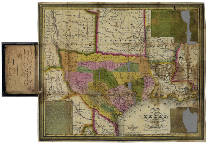
Map of Texas with Parts of the Adjoining States

Print $20.00
- Digital $50.00
Map of Texas with Parts of the Adjoining States
1837
Size: 31.5 x 24.9 inches
2114
Genl. Austins Map of Texas With Parts of the Adjoining States

Print $20.00
- Digital $50.00
Genl. Austins Map of Texas With Parts of the Adjoining States
1840
Size: 28.5 x 23.4 inches
2116
Carte du Texas par M. Maris

Print $20.00
- Digital $50.00
Carte du Texas par M. Maris
1846
Size: 19.3 x 17.2 inches
2119
Map of Texas from the most recent authorities

Map of Texas from the most recent authorities
1845
Size: 11.2 x 17.2 inches
4333
Map of Texas in 1836

Print $20.00
- Digital $50.00
Map of Texas in 1836
1936
Size: 24.5 x 19.3 inches
449
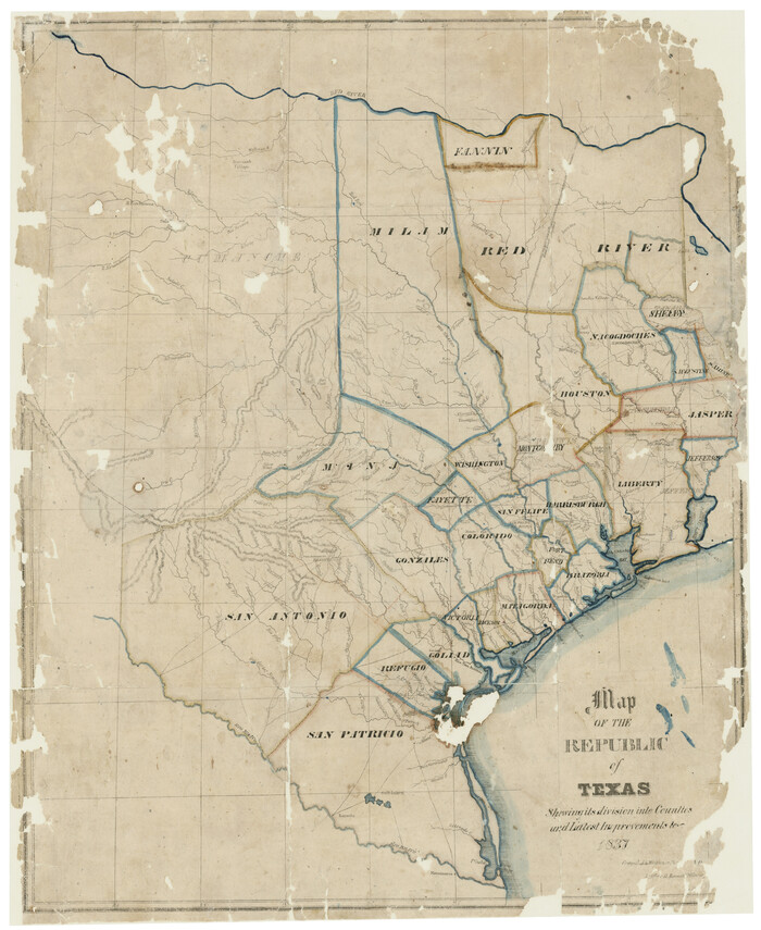
Map of the Republic of Texas Shewing [sic] its division into Counties and Latest Improvements to 1837
Print $20.00
- Digital $50.00
Map of the Republic of Texas Shewing [sic] its division into Counties and Latest Improvements to 1837
1837
Size: 28.2 x 23.0 inches
476
Map of Texas Compiled from Surveys recorded in the Land Office of Texas

Print $20.00
- Digital $50.00
Map of Texas Compiled from Surveys recorded in the Land Office of Texas
1841
Size: 26.4 x 22.3 inches
538
[Field notes, sketch and legislation regarding the National Road from Dallas at the mouth of the Elm Fork of the Trinity to the mouth of Kiamechi on Red River]
![65469, [Field notes, sketch and legislation regarding the National Road from Dallas at the mouth of the Elm Fork of the Trinity to the mouth of Kiamechi on Red River], General Map Collection](https://historictexasmaps.com/wmedia_w700/pdf_converted_jpg/qi_pdf_thumbnail_19857.jpg)
Print $84.00
- Digital $50.00
[Field notes, sketch and legislation regarding the National Road from Dallas at the mouth of the Elm Fork of the Trinity to the mouth of Kiamechi on Red River]
1844
Size: 6.8 x 11.2 inches
65469
Map of Texas and the countries adjacent compiled in the Bureau of the Corps of Topographical Engineers from the best authorities for the State Department

Print $20.00
- Digital $50.00
Map of Texas and the countries adjacent compiled in the Bureau of the Corps of Topographical Engineers from the best authorities for the State Department
1844
Size: 25.9 x 18.2 inches
72714
Map of Texas and the countries adjacent compiled in the Bureau of the Corps of Topographical Engineers from the best authorities for the State Department

Print $20.00
- Digital $50.00
Map of Texas and the countries adjacent compiled in the Bureau of the Corps of Topographical Engineers from the best authorities for the State Department
1844
Size: 26.1 x 18.2 inches
72715
Map of Texas and the country adjacent

Print $20.00
- Digital $50.00
Map of Texas and the country adjacent
1844
Size: 18.3 x 26.5 inches
73052
Current Miscellaneous File 105

Print $18.00
- Digital $50.00
Current Miscellaneous File 105
Size: 8.8 x 14.2 inches
74680
Map of Texas with Parts of the Adjoining States

Print $20.00
Map of Texas with Parts of the Adjoining States
1836
Size: 29.5 x 23.6 inches
76193
Map of Texas and the Countries Adjacent compiled in the Bureau of the Corps of Topographical Engineers from the Best Authorities

Print $20.00
Map of Texas and the Countries Adjacent compiled in the Bureau of the Corps of Topographical Engineers from the Best Authorities
1844
Size: 24.5 x 35.8 inches
76197
Map of Texas, compiled from surveys on record in the General Land Office of the Republic

Print $20.00
Map of Texas, compiled from surveys on record in the General Land Office of the Republic
1839
Size: 32.0 x 24.9 inches
76198
Map of the Republic of Texas and the Adjacent Territories, Indicating the Grants of Land Conceded under the Empresario System of Mexico

Print $20.00
Map of the Republic of Texas and the Adjacent Territories, Indicating the Grants of Land Conceded under the Empresario System of Mexico
1841
Size: 13.4 x 16.7 inches
76244
Map of Texas Containing the Latest Grants and Discoveries

Print $20.00
Map of Texas Containing the Latest Grants and Discoveries
1836
Size: 16.2 x 10.6 inches
76245
Map of Texas compiled from surveys recorded in the Land Office of Texas, and other official surveys

Print $20.00
Map of Texas compiled from surveys recorded in the Land Office of Texas, and other official surveys
1841
Size: 25.1 x 20.4 inches
76253
Central America Including Texas, California, and the Northern States Mexico

Print $20.00
Central America Including Texas, California, and the Northern States Mexico
1842
Size: 13.8 x 16.7 inches
76273
New Map of Texas with the Contiguous American and Mexican States
Print $20.00
- Digital $50.00
New Map of Texas with the Contiguous American and Mexican States
1836
Size: 13.7 x 19.7 inches
76795
Calhoun County Sketch File 20

Print $10.00
Calhoun County Sketch File 20
1839
Size: 8.8 x 8.6 inches
76865
Map of the Republic of Texas showing its division into counties and latest improvements too

Print $20.00
- Digital $50.00
Map of the Republic of Texas showing its division into counties and latest improvements too
1837
Size: 12.3 x 9.6 inches
76874
Genl. Austins Map of Texas With Parts of the Adjoining States

Print $20.00
Genl. Austins Map of Texas With Parts of the Adjoining States
1840
Size: 30.1 x 24.5 inches
79293

Karte von Texas entworfen nach den Vermessungen, welche in den Acten der General-Land-Office der Republic liegen bis zum Jahr 1839 von Richard S. Hunt & Jesse F. Randel

Print $20.00
Karte von Texas entworfen nach den Vermessungen, welche in den Acten der General-Land-Office der Republic liegen bis zum Jahr 1839 von Richard S. Hunt & Jesse F. Randel
1841
Size: 19.6 x 14.6 inches
79311
Texas and part of Mexico and the United States showing the Route of the First Santa Fe Expedition

Print $20.00
Texas and part of Mexico and the United States showing the Route of the First Santa Fe Expedition
1844
Size: 20.3 x 15.8 inches
79730
Map of Texas Compiled from surveys on record in the General Land Office of the Republic to the year 1839
Print $20.00
- Digital $50.00
Map of Texas Compiled from surveys on record in the General Land Office of the Republic to the year 1839
1891
-
Size
36.6 x 25.7 inches
-
Map/Doc
1891
-
Creation Date
1891
The Republic of Texas, March 2, 1836 - February 19, 1846
The Republic of Texas, March 2, 1836 - February 19, 1846
1972
-
Size
23.4 x 18.3 inches
-
Map/Doc
2109
-
Creation Date
1972
Map of Texas in 1836
Print $20.00
- Digital $50.00
Map of Texas in 1836
1936
-
Size
32.1 x 24.4 inches
-
Map/Doc
2110
-
Creation Date
1936
Map of Texas with Parts of the Adjoining States
Print $20.00
- Digital $50.00
Map of Texas with Parts of the Adjoining States
1837
-
Size
31.5 x 24.9 inches
-
Map/Doc
2114
-
Creation Date
1837
Genl. Austins Map of Texas With Parts of the Adjoining States
Print $20.00
- Digital $50.00
Genl. Austins Map of Texas With Parts of the Adjoining States
1840
-
Size
28.5 x 23.4 inches
-
Map/Doc
2116
-
Creation Date
1840
Carte du Texas par M. Maris
Print $20.00
- Digital $50.00
Carte du Texas par M. Maris
1846
-
Size
19.3 x 17.2 inches
-
Map/Doc
2119
-
Creation Date
1846
Map of Texas from the most recent authorities
Map of Texas from the most recent authorities
1845
-
Size
11.2 x 17.2 inches
-
Map/Doc
4333
-
Creation Date
1845
Texas

Print $20.00
- Digital $50.00
Texas
1844
-
Size
17.0 x 13.3 inches
-
Map/Doc
4474
-
Creation Date
1844
Map of Texas in 1836
Print $20.00
- Digital $50.00
Map of Texas in 1836
1936
-
Size
24.5 x 19.3 inches
-
Map/Doc
449
-
Creation Date
1936
Map of the Republic of Texas Shewing [sic] its division into Counties and Latest Improvements to 1837
Print $20.00
- Digital $50.00
Map of the Republic of Texas Shewing [sic] its division into Counties and Latest Improvements to 1837
1837
-
Size
28.2 x 23.0 inches
-
Map/Doc
476
-
Creation Date
1837
Map of Texas Compiled from Surveys recorded in the Land Office of Texas
Print $20.00
- Digital $50.00
Map of Texas Compiled from Surveys recorded in the Land Office of Texas
1841
-
Size
26.4 x 22.3 inches
-
Map/Doc
538
-
Creation Date
1841
[Field notes, sketch and legislation regarding the National Road from Dallas at the mouth of the Elm Fork of the Trinity to the mouth of Kiamechi on Red River]
Print $84.00
- Digital $50.00
[Field notes, sketch and legislation regarding the National Road from Dallas at the mouth of the Elm Fork of the Trinity to the mouth of Kiamechi on Red River]
1844
-
Size
6.8 x 11.2 inches
-
Map/Doc
65469
-
Creation Date
1844
Map of Texas and the countries adjacent compiled in the Bureau of the Corps of Topographical Engineers from the best authorities for the State Department
Print $20.00
- Digital $50.00
Map of Texas and the countries adjacent compiled in the Bureau of the Corps of Topographical Engineers from the best authorities for the State Department
1844
-
Size
25.9 x 18.2 inches
-
Map/Doc
72714
-
Creation Date
1844
Map of Texas and the countries adjacent compiled in the Bureau of the Corps of Topographical Engineers from the best authorities for the State Department
Print $20.00
- Digital $50.00
Map of Texas and the countries adjacent compiled in the Bureau of the Corps of Topographical Engineers from the best authorities for the State Department
1844
-
Size
26.1 x 18.2 inches
-
Map/Doc
72715
-
Creation Date
1844
Map of Texas and the country adjacent
Print $20.00
- Digital $50.00
Map of Texas and the country adjacent
1844
-
Size
18.3 x 26.5 inches
-
Map/Doc
73052
-
Creation Date
1844
Current Miscellaneous File 105
Print $18.00
- Digital $50.00
Current Miscellaneous File 105
-
Size
8.8 x 14.2 inches
-
Map/Doc
74680
Map of Texas with Parts of the Adjoining States
Print $20.00
Map of Texas with Parts of the Adjoining States
1836
-
Size
29.5 x 23.6 inches
-
Map/Doc
76193
-
Creation Date
1836
Map of Texas and the Countries Adjacent compiled in the Bureau of the Corps of Topographical Engineers from the Best Authorities
Print $20.00
Map of Texas and the Countries Adjacent compiled in the Bureau of the Corps of Topographical Engineers from the Best Authorities
1844
-
Size
24.5 x 35.8 inches
-
Map/Doc
76197
-
Creation Date
1844
Map of Texas, compiled from surveys on record in the General Land Office of the Republic
Print $20.00
Map of Texas, compiled from surveys on record in the General Land Office of the Republic
1839
-
Size
32.0 x 24.9 inches
-
Map/Doc
76198
-
Creation Date
1839
Map of the Republic of Texas and the Adjacent Territories, Indicating the Grants of Land Conceded under the Empresario System of Mexico
Print $20.00
Map of the Republic of Texas and the Adjacent Territories, Indicating the Grants of Land Conceded under the Empresario System of Mexico
1841
-
Size
13.4 x 16.7 inches
-
Map/Doc
76244
-
Creation Date
1841
Map of Texas Containing the Latest Grants and Discoveries
Print $20.00
Map of Texas Containing the Latest Grants and Discoveries
1836
-
Size
16.2 x 10.6 inches
-
Map/Doc
76245
-
Creation Date
1836
Map of Texas compiled from surveys recorded in the Land Office of Texas, and other official surveys
Print $20.00
Map of Texas compiled from surveys recorded in the Land Office of Texas, and other official surveys
1841
-
Size
25.1 x 20.4 inches
-
Map/Doc
76253
-
Creation Date
1841
Central America Including Texas, California, and the Northern States Mexico
Print $20.00
Central America Including Texas, California, and the Northern States Mexico
1842
-
Size
13.8 x 16.7 inches
-
Map/Doc
76273
-
Creation Date
1842
New Map of Texas with the Contiguous American and Mexican States
Print $20.00
- Digital $50.00
New Map of Texas with the Contiguous American and Mexican States
1836
-
Size
13.7 x 19.7 inches
-
Map/Doc
76795
-
Creation Date
1836
Calhoun County Sketch File 20
Print $10.00
Calhoun County Sketch File 20
1839
-
Size
8.8 x 8.6 inches
-
Map/Doc
76865
-
Creation Date
1839
Map of the Republic of Texas showing its division into counties and latest improvements too
Print $20.00
- Digital $50.00
Map of the Republic of Texas showing its division into counties and latest improvements too
1837
-
Size
12.3 x 9.6 inches
-
Map/Doc
76874
-
Creation Date
1837
Genl. Austins Map of Texas With Parts of the Adjoining States
Print $20.00
Genl. Austins Map of Texas With Parts of the Adjoining States
1840
-
Size
30.1 x 24.5 inches
-
Map/Doc
79293
-
Creation Date
1840
Karte von Texas entworfen nach den Vermessungen, welche in den Acten der General-Land-Office der Republic liegen bis zum Jahr 1839 von Richard S. Hunt & Jesse F. Randel
Print $20.00
Karte von Texas entworfen nach den Vermessungen, welche in den Acten der General-Land-Office der Republic liegen bis zum Jahr 1839 von Richard S. Hunt & Jesse F. Randel
1841
-
Size
19.6 x 14.6 inches
-
Map/Doc
79311
-
Creation Date
1841
Texas and part of Mexico and the United States showing the Route of the First Santa Fe Expedition
Print $20.00
Texas and part of Mexico and the United States showing the Route of the First Santa Fe Expedition
1844
-
Size
20.3 x 15.8 inches
-
Map/Doc
79730
-
Creation Date
1844