Geodetic positions of authentic boundary mounds, established by Louisiana Geodetic Survey traverse

Print $4.00
- Digital $50.00
Geodetic positions of authentic boundary mounds, established by Louisiana Geodetic Survey traverse
Size: 28.8 x 28.7 inches
1734
Report on the Meridional Boundary between Louisiana and Texas, retracement by the Louisiana Geodetic Survey

Print $2.00
- Digital $50.00
Report on the Meridional Boundary between Louisiana and Texas, retracement by the Louisiana Geodetic Survey
Size: 11.2 x 8.8 inches
61174

Texas Panhandle East Boundary Line

Print $40.00
- Digital $50.00
Texas Panhandle East Boundary Line
Size: 66.1 x 9.3 inches
65380
Texas Panhandle East Boundary Line

Print $20.00
- Digital $50.00
Texas Panhandle East Boundary Line
Size: 37.5 x 8.7 inches
65381
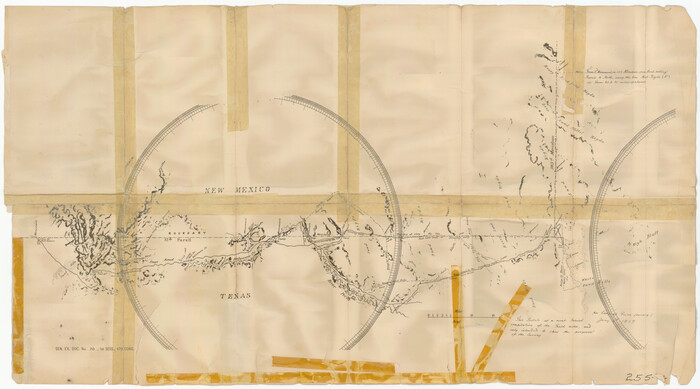
Sketch of 103rd Meridian, W. L. Showing Conflict of Capitol Leagues

Print $40.00
- Digital $50.00
Sketch of 103rd Meridian, W. L. Showing Conflict of Capitol Leagues
Size: 25.8 x 122.0 inches
65504
Sketch of 103rd Meridian, W. L. Showing Conflict of Capitol Leagues

Print $40.00
- Digital $50.00
Sketch of 103rd Meridian, W. L. Showing Conflict of Capitol Leagues
Size: 26.9 x 85.1 inches
65505
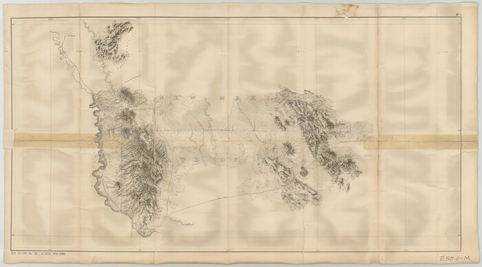
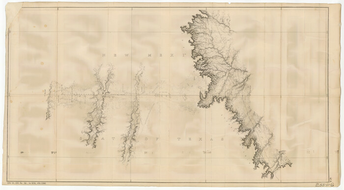
Map of survey of the 100th Meridian west longitude, extending from the north bank of Red River to the intersection of the Northern Boundary of the Creek or Seminole Country

Print $40.00
- Digital $50.00
Map of survey of the 100th Meridian west longitude, extending from the north bank of Red River to the intersection of the Northern Boundary of the Creek or Seminole Country
Size: 112.5 x 10.3 inches
73565
Current Miscellaneous File 38

Print $8.00
- Digital $50.00
Current Miscellaneous File 38
Size: 8.6 x 13.0 inches
73958
Current Miscellaneous File 39

Print $20.00
- Digital $50.00
Current Miscellaneous File 39
Size: 11.2 x 8.8 inches
73962
Current Miscellaneous File 102

Print $611.00
- Digital $50.00
Current Miscellaneous File 102
Size: 11.5 x 7.1 inches
74379
Current Miscellaneous File 105

Print $18.00
- Digital $50.00
Current Miscellaneous File 105
Size: 8.8 x 14.2 inches
74680
Texas State Boundary Line 3

Print $90.00
- Digital $50.00
Texas State Boundary Line 3
Size: 10.9 x 8.2 inches
74904
Texas State Boundary Line 4

Print $20.00
- Digital $50.00
Texas State Boundary Line 4
Size: 11.2 x 8.7 inches
74949
Texas-United States Boundary Line 3

Print $40.00
- Digital $50.00
Texas-United States Boundary Line 3
Size: 54.6 x 10.5 inches
74979
Texas-Oklahoma Paris Quadrangle

Print $20.00
- Digital $50.00
Texas-Oklahoma Paris Quadrangle
Size: 22.3 x 18.4 inches
75107
Texas-Oklahoma Clarksville Quadrangle

Print $20.00
- Digital $50.00
Texas-Oklahoma Clarksville Quadrangle
Size: 22.2 x 18.3 inches
75109
Geological Survey of Texas, First Annual Report, Plate II, Figures 6, 7, 8, 9

Print $20.00
- Digital $50.00
Geological Survey of Texas, First Annual Report, Plate II, Figures 6, 7, 8, 9
Size: 17.1 x 18.1 inches
75114
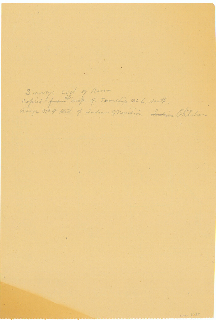
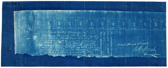
[Surveys East of river copied from U.S. map of Township No. 6 South, Range No. 9 West of the Indian Meridian, Oklahoma]
Print $2.00
- Digital $50.00
[Surveys East of river copied from U.S. map of Township No. 6 South, Range No. 9 West of the Indian Meridian, Oklahoma]
Size: 13.3 x 9.0 inches
75185
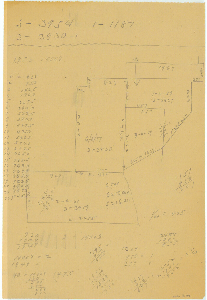
[Surveys East of river copied from U.S. map of Township No. 6 South, Range No. 9 West of the Indian Meridian, Oklahoma]
Print $2.00
- Digital $50.00
[Surveys East of river copied from U.S. map of Township No. 6 South, Range No. 9 West of the Indian Meridian, Oklahoma]
Size: 13.3 x 9.2 inches
75186
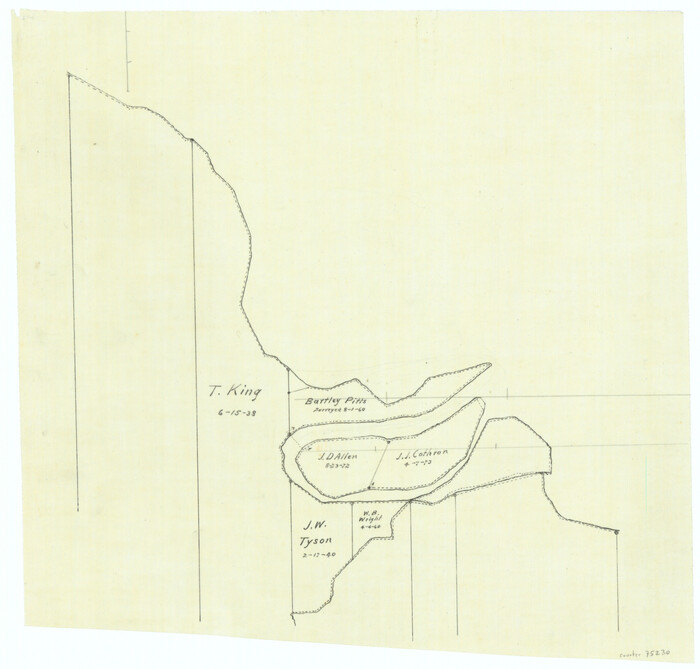
[Overlay for Fractional Township No. 7 South Range No. 17 East of the Indian Meridian, Indian Territory]
Print $3.00
- Digital $50.00
[Overlay for Fractional Township No. 7 South Range No. 17 East of the Indian Meridian, Indian Territory]
Size: 11.2 x 11.7 inches
75230
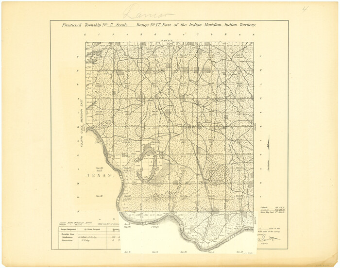
[Fractional Township No. 7 South Range No. 17 East of the Indian Meridian, Indian Territory]
Print $20.00
- Digital $50.00
[Fractional Township No. 7 South Range No. 17 East of the Indian Meridian, Indian Territory]
Size: 19.2 x 24.3 inches
75231
In the Supreme Court of the United States, The State of Oklahoma, Complainant vs. The State of Texas, Defendant, The United States of America, Intervener, Red River Valley, Texas and Oklahoma Between the 98th and 100th Meridians in Five Sheets, 1921

Print $40.00
- Digital $50.00
In the Supreme Court of the United States, The State of Oklahoma, Complainant vs. The State of Texas, Defendant, The United States of America, Intervener, Red River Valley, Texas and Oklahoma Between the 98th and 100th Meridians in Five Sheets, 1921
Size: 38.3 x 60.1 inches
75279
Proceedings of the International Boundary Commission, United States and Mexico, American Section, Elimination of Fifty-Seven Old Bancos Specifically Described in the Treaty of 1905

Proceedings of the International Boundary Commission, United States and Mexico, American Section, Elimination of Fifty-Seven Old Bancos Specifically Described in the Treaty of 1905
Size: 12.2 x 9.3 inches
83124
Proceedings of the International Boundary Commission, United States and Mexico, American Section, Elimination of Bancos, Treaty of 1905

Proceedings of the International Boundary Commission, United States and Mexico, American Section, Elimination of Bancos, Treaty of 1905
Size: 12.4 x 9.6 inches
83125
Sketch of 103rd Meridian, W. L. showing Conflict of Capitol Leagues

Print $20.00
- Digital $50.00
Sketch of 103rd Meridian, W. L. showing Conflict of Capitol Leagues
Size: 8.1 x 22.1 inches
90578
[State Line - 103rd Meridian - in relation to Leagues]
Print $20.00
- Digital $50.00
[State Line - 103rd Meridian - in relation to Leagues]
Size: 19.9 x 8.3 inches
91551
[Texas Boundary Line]
Print $20.00
- Digital $50.00
[Texas Boundary Line]
Size: 31.8 x 18.1 inches
92069
[Texas Boundary Line]
Print $20.00
- Digital $50.00
[Texas Boundary Line]
Size: 21.5 x 12.0 inches
92070
[Texas Boundary Line]
Print $20.00
- Digital $50.00
[Texas Boundary Line]
Size: 21.5 x 12.0 inches
92071
Geodetic positions of authentic boundary mounds, established by Louisiana Geodetic Survey traverse
Print $4.00
- Digital $50.00
Geodetic positions of authentic boundary mounds, established by Louisiana Geodetic Survey traverse
-
Size
28.8 x 28.7 inches
-
Map/Doc
1734
Report on the Meridional Boundary between Louisiana and Texas, retracement by the Louisiana Geodetic Survey
Print $2.00
- Digital $50.00
Report on the Meridional Boundary between Louisiana and Texas, retracement by the Louisiana Geodetic Survey
-
Size
11.2 x 8.8 inches
-
Map/Doc
61174
Texas Panhandle East Boundary Line
Print $40.00
- Digital $50.00
Texas Panhandle East Boundary Line
-
Size
66.1 x 9.3 inches
-
Map/Doc
65380
Texas Panhandle East Boundary Line
Print $20.00
- Digital $50.00
Texas Panhandle East Boundary Line
-
Size
37.5 x 8.7 inches
-
Map/Doc
65381
Sketch of 103rd Meridian, W. L. Showing Conflict of Capitol Leagues
Print $40.00
- Digital $50.00
Sketch of 103rd Meridian, W. L. Showing Conflict of Capitol Leagues
-
Size
25.8 x 122.0 inches
-
Map/Doc
65504
Sketch of 103rd Meridian, W. L. Showing Conflict of Capitol Leagues
Print $40.00
- Digital $50.00
Sketch of 103rd Meridian, W. L. Showing Conflict of Capitol Leagues
-
Size
26.9 x 85.1 inches
-
Map/Doc
65505
Map of survey of the 100th Meridian west longitude, extending from the north bank of Red River to the intersection of the Northern Boundary of the Creek or Seminole Country
Print $40.00
- Digital $50.00
Map of survey of the 100th Meridian west longitude, extending from the north bank of Red River to the intersection of the Northern Boundary of the Creek or Seminole Country
-
Size
112.5 x 10.3 inches
-
Map/Doc
73565
Current Miscellaneous File 38
Print $8.00
- Digital $50.00
Current Miscellaneous File 38
-
Size
8.6 x 13.0 inches
-
Map/Doc
73958
Current Miscellaneous File 39
Print $20.00
- Digital $50.00
Current Miscellaneous File 39
-
Size
11.2 x 8.8 inches
-
Map/Doc
73962
Current Miscellaneous File 102
Print $611.00
- Digital $50.00
Current Miscellaneous File 102
-
Size
11.5 x 7.1 inches
-
Map/Doc
74379
Current Miscellaneous File 105
Print $18.00
- Digital $50.00
Current Miscellaneous File 105
-
Size
8.8 x 14.2 inches
-
Map/Doc
74680
Texas State Boundary Line 3
Print $90.00
- Digital $50.00
Texas State Boundary Line 3
-
Size
10.9 x 8.2 inches
-
Map/Doc
74904
Texas State Boundary Line 4
Print $20.00
- Digital $50.00
Texas State Boundary Line 4
-
Size
11.2 x 8.7 inches
-
Map/Doc
74949
Texas-United States Boundary Line 3
Print $40.00
- Digital $50.00
Texas-United States Boundary Line 3
-
Size
54.6 x 10.5 inches
-
Map/Doc
74979
Texas-Oklahoma Paris Quadrangle
Print $20.00
- Digital $50.00
Texas-Oklahoma Paris Quadrangle
-
Size
22.3 x 18.4 inches
-
Map/Doc
75107
Texas-Oklahoma Clarksville Quadrangle
Print $20.00
- Digital $50.00
Texas-Oklahoma Clarksville Quadrangle
-
Size
22.2 x 18.3 inches
-
Map/Doc
75109
Geological Survey of Texas, First Annual Report, Plate II, Figures 6, 7, 8, 9
Print $20.00
- Digital $50.00
Geological Survey of Texas, First Annual Report, Plate II, Figures 6, 7, 8, 9
-
Size
17.1 x 18.1 inches
-
Map/Doc
75114
[Surveys East of river copied from U.S. map of Township No. 6 South, Range No. 9 West of the Indian Meridian, Oklahoma]
Print $2.00
- Digital $50.00
[Surveys East of river copied from U.S. map of Township No. 6 South, Range No. 9 West of the Indian Meridian, Oklahoma]
-
Size
13.3 x 9.0 inches
-
Map/Doc
75185
[Surveys East of river copied from U.S. map of Township No. 6 South, Range No. 9 West of the Indian Meridian, Oklahoma]
Print $2.00
- Digital $50.00
[Surveys East of river copied from U.S. map of Township No. 6 South, Range No. 9 West of the Indian Meridian, Oklahoma]
-
Size
13.3 x 9.2 inches
-
Map/Doc
75186
[Overlay for Fractional Township No. 7 South Range No. 17 East of the Indian Meridian, Indian Territory]
Print $3.00
- Digital $50.00
[Overlay for Fractional Township No. 7 South Range No. 17 East of the Indian Meridian, Indian Territory]
-
Size
11.2 x 11.7 inches
-
Map/Doc
75230
[Fractional Township No. 7 South Range No. 17 East of the Indian Meridian, Indian Territory]
Print $20.00
- Digital $50.00
[Fractional Township No. 7 South Range No. 17 East of the Indian Meridian, Indian Territory]
-
Size
19.2 x 24.3 inches
-
Map/Doc
75231
In the Supreme Court of the United States, The State of Oklahoma, Complainant vs. The State of Texas, Defendant, The United States of America, Intervener, Red River Valley, Texas and Oklahoma Between the 98th and 100th Meridians in Five Sheets, 1921
Print $40.00
- Digital $50.00
In the Supreme Court of the United States, The State of Oklahoma, Complainant vs. The State of Texas, Defendant, The United States of America, Intervener, Red River Valley, Texas and Oklahoma Between the 98th and 100th Meridians in Five Sheets, 1921
-
Size
38.3 x 60.1 inches
-
Map/Doc
75279
Proceedings of the International Boundary Commission, United States and Mexico, American Section, Elimination of Fifty-Seven Old Bancos Specifically Described in the Treaty of 1905
Proceedings of the International Boundary Commission, United States and Mexico, American Section, Elimination of Fifty-Seven Old Bancos Specifically Described in the Treaty of 1905
-
Size
12.2 x 9.3 inches
-
Map/Doc
83124
Proceedings of the International Boundary Commission, United States and Mexico, American Section, Elimination of Bancos, Treaty of 1905
Proceedings of the International Boundary Commission, United States and Mexico, American Section, Elimination of Bancos, Treaty of 1905
-
Size
12.4 x 9.6 inches
-
Map/Doc
83125
Sketch of 103rd Meridian, W. L. showing Conflict of Capitol Leagues
Print $20.00
- Digital $50.00
Sketch of 103rd Meridian, W. L. showing Conflict of Capitol Leagues
-
Size
8.1 x 22.1 inches
-
Map/Doc
90578
[State Line - 103rd Meridian - in relation to Leagues]
Print $20.00
- Digital $50.00
[State Line - 103rd Meridian - in relation to Leagues]
-
Size
19.9 x 8.3 inches
-
Map/Doc
91551
[Texas Boundary Line]
Print $20.00
- Digital $50.00
[Texas Boundary Line]
-
Size
31.8 x 18.1 inches
-
Map/Doc
92069
[Texas Boundary Line]
Print $20.00
- Digital $50.00
[Texas Boundary Line]
-
Size
21.5 x 12.0 inches
-
Map/Doc
92070
[Texas Boundary Line]
Print $20.00
- Digital $50.00
[Texas Boundary Line]
-
Size
21.5 x 12.0 inches
-
Map/Doc
92071