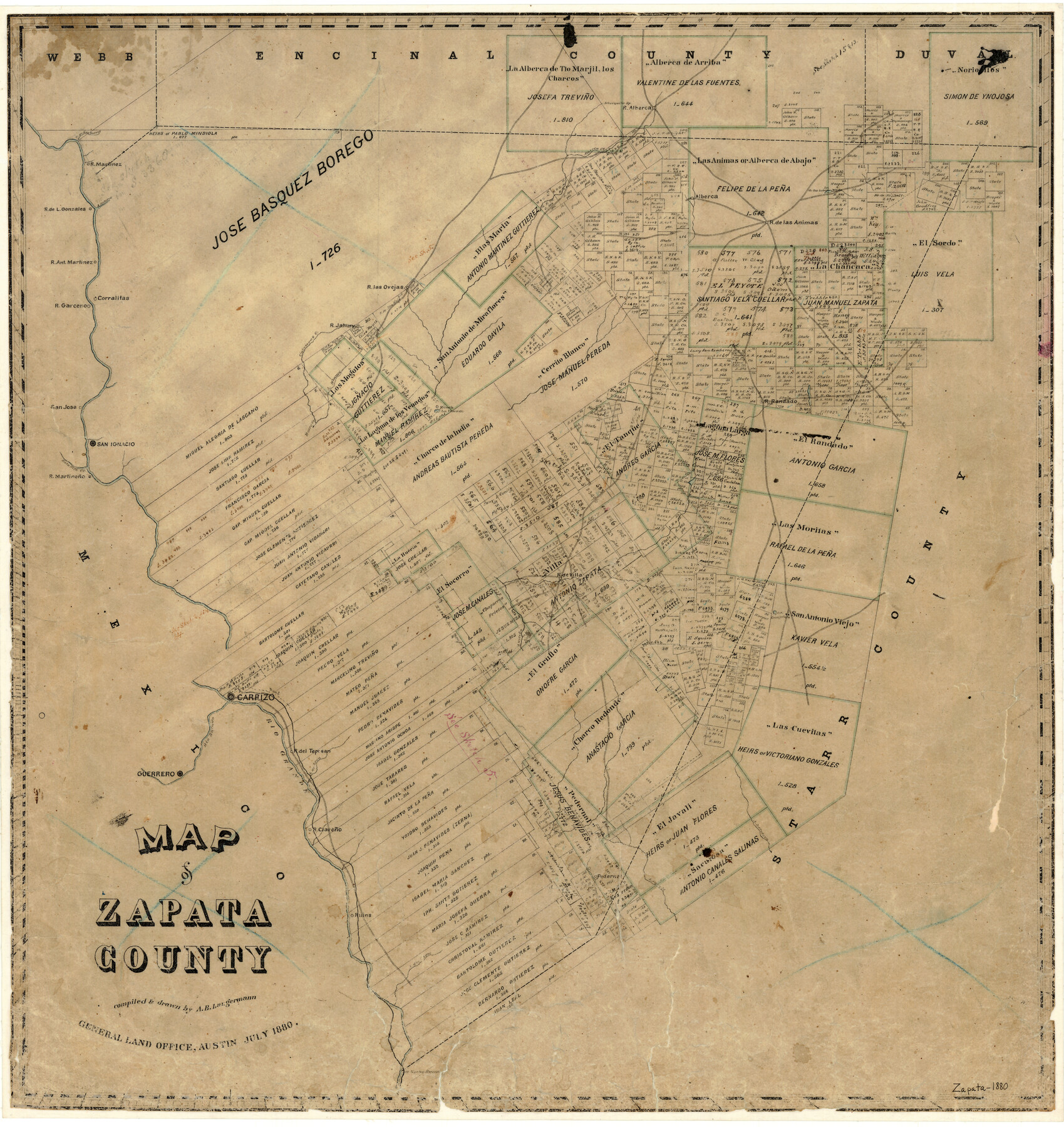
Map of Zapata County
-
Map/Doc
4176
-
Collection
General Map Collection
-
Object Dates
12/1879 (Creation Date)
-
People and Organizations
Texas General Land Office (Publisher)
A.B. Langermann (Compiler)
A.B. Langermann (Draftsman)
-
Counties
Zapata
-
Subjects
County
-
Height x Width
27.4 x 25.6 inches
69.6 x 65.0 cm
-
Features
Arroyo del Tigre
San Ignacio
Burro Creek
Laguna Hinojosena
Rancho Randado
Laguna del Guisache
Laguna Larga
Carrizo
Rio Salado
Rio Grande
Rancho del Teposan
Arroyo de Leon
Rancho Clareño
Arroyo Sacatosa
Arroyo Javali
Corralitas
Arroyo del Sandia
Las Morteros Creek
Rancho Martinez
Saladito Hill
Nogal Creek
Rancho Martineño
Rancho de los Animas
Laguna Guajolote
Rancho de Villa
Arroyo Veleño
Paso las Lajas
Rancho Barrosas
Arroyo del Poro
Rancho Jahury
Alberquito Springs
Alberca Creek
Rancho Alberca
Laguna de Hilario
Laguna de Zacatones
Laguna de Lobos
Alberca
Cañada de la Presa
Picacho Mountain
Arroyo Dolores
Rancho de L. Gonzales
Rancho Ant. Martinez
Rancho Garceno
Corralitas Ranch
Cañada de San Andres
Rancho las Ovejas
Banquitos Hill
Carrizo Road
Corpus Christi Road
Cañada del Coyote
Dry Creek
D. de los Comitas
Laguna Venado
Arroyo Blanco
Cabaceras Creek
Cerro Francisco
Puerta Creek
San Jose
Part of: General Map Collection
Map illustrating the general geological features of the country west of the Mississippi River compiled from the surveys of W.H. Emory and from the Pacific Railroad surveys & other sources

Print $20.00
- Digital $50.00
Map illustrating the general geological features of the country west of the Mississippi River compiled from the surveys of W.H. Emory and from the Pacific Railroad surveys & other sources
1857
Size 21.2 x 24.7 inches
Map/Doc 95172
Bandera County Rolled Sketch 4

Print $20.00
- Digital $50.00
Bandera County Rolled Sketch 4
1963
Size 36.0 x 28.5 inches
Map/Doc 5116

Val Verde County Rolled Sketch 55

Print $20.00
- Digital $50.00
Val Verde County Rolled Sketch 55
1940
Size 32.0 x 23.3 inches
Map/Doc 8124
Crockett County Sketch File 6

Print $20.00
- Digital $50.00
Crockett County Sketch File 6
1877
Size 22.2 x 17.2 inches
Map/Doc 3457
Map of Hopkins County

Print $20.00
- Digital $50.00
Map of Hopkins County
1872
Size 17.8 x 18.4 inches
Map/Doc 4566
Cooke County Working Sketch 7

Print $20.00
- Digital $50.00
Cooke County Working Sketch 7
1939
Size 25.1 x 33.7 inches
Map/Doc 68244
Harris County Working Sketch 85

Print $20.00
- Digital $50.00
Harris County Working Sketch 85
1971
Size 41.5 x 44.0 inches
Map/Doc 65977
Roberts County Working Sketch 28

Print $20.00
- Digital $50.00
Roberts County Working Sketch 28
1983
Size 39.7 x 29.8 inches
Map/Doc 63554
Stonewall County Sketch File 30

Print $120.00
- Digital $50.00
Stonewall County Sketch File 30
1986
Size 24.5 x 35.3 inches
Map/Doc 12370
San Jacinto County Working Sketch 5

Print $20.00
- Digital $50.00
San Jacinto County Working Sketch 5
1934
Size 16.5 x 21.2 inches
Map/Doc 63718

You may also like
Passage par terre a la Californie decouvert par le R.P. Eusebe-Francois Kino Jesuite depuis 1698 jusqua 1701 ou l'on voit encore les nouvelles Missions des PP. de la Compagnie de Texas

Print $20.00
- Digital $50.00
Passage par terre a la Californie decouvert par le R.P. Eusebe-Francois Kino Jesuite depuis 1698 jusqua 1701 ou l'on voit encore les nouvelles Missions des PP. de la Compagnie de Texas
1819
Size 10.7 x 10.6 inches
Map/Doc 96567
Kerr County Working Sketch 27

Print $20.00
- Digital $50.00
Kerr County Working Sketch 27
1970
Size 25.4 x 20.8 inches
Map/Doc 70058
Copy of Surveyor's Field Book, Morris Browning - In Blocks 7, 5 & 4, I&GNRRCo., Hutchinson and Carson Counties, Texas

Print $2.00
- Digital $50.00
Copy of Surveyor's Field Book, Morris Browning - In Blocks 7, 5 & 4, I&GNRRCo., Hutchinson and Carson Counties, Texas
1888
Size 6.9 x 8.8 inches
Map/Doc 62283
West Part of Liberty Co.

Print $40.00
- Digital $50.00
West Part of Liberty Co.
1977
Size 48.0 x 36.9 inches
Map/Doc 95570
Old Miscellaneous File 35

Print $4.00
- Digital $50.00
Old Miscellaneous File 35
1882
Size 13.9 x 8.6 inches
Map/Doc 75757
Colorado County Sketch File 12

Print $20.00
- Digital $50.00
Colorado County Sketch File 12
Size 14.6 x 17.8 inches
Map/Doc 11135
Cottle County Rolled Sketch 14

Print $741.00
- Digital $50.00
Cottle County Rolled Sketch 14
1882
Size 10.8 x 16.0 inches
Map/Doc 42369
Comanche County Sketch File 26

Print $20.00
- Digital $50.00
Comanche County Sketch File 26
Size 18.0 x 17.5 inches
Map/Doc 11144
Rand McNally Main Highway Map of Texas

Print $20.00
Rand McNally Main Highway Map of Texas
1923
Size 27.7 x 40.3 inches
Map/Doc 76260
[Southwest Portion of Lynn County, Southeast Portion of Terry County]
![91305, [Southwest Portion of Lynn County, Southeast Portion of Terry County], Twichell Survey Records](https://historictexasmaps.com/wmedia_w700/maps/91305-1.tif.jpg)
Print $20.00
- Digital $50.00
[Southwest Portion of Lynn County, Southeast Portion of Terry County]
1952
Size 34.3 x 35.1 inches
Map/Doc 91305
Current Miscellaneous File 4

Print $8.00
- Digital $50.00
Current Miscellaneous File 4
1947
Size 11.5 x 9.1 inches
Map/Doc 73723
Taylor County Working Sketch 18

Print $20.00
- Digital $50.00
Taylor County Working Sketch 18
1985
Size 43.2 x 46.0 inches
Map/Doc 69628