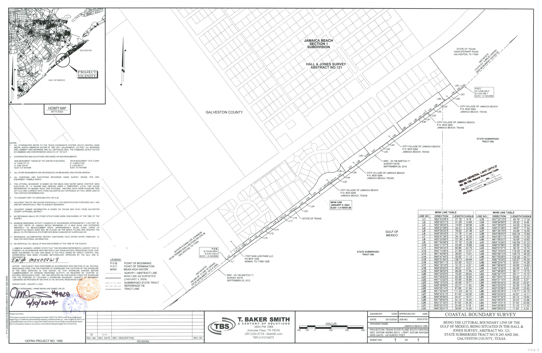
Galveston County NRC Article 33.136 Sketch 95
Coastal Boundary Survey being the littoral boundary line of the Gulf of Mexico, being situated in the Hall & Jones Survey, Abstract No. 121, State submerged tract nos. 265 and 266
-
Map/Doc
97368
-
Collection
General Map Collection
-
Object Dates
6/10/2024 (Creation Date)
11/21/2024 (File Date)
-
People and Organizations
James M. Naismith (Surveyor/Engineer)
-
Counties
Galveston
-
Subjects
Surveying CBS
-
Comments
Project: E Hall-Levi Jones, A-121-Jamaica Beach, SOTLS 265 & 266
Project No.: CEPRA Project No. 1482
Part of: General Map Collection
Hamilton County Working Sketch 28

Print $6.00
- Digital $50.00
Hamilton County Working Sketch 28
1976
Size 27.7 x 33.2 inches
Map/Doc 63366
Limestone County Sketch File 11

Print $4.00
- Digital $50.00
Limestone County Sketch File 11
1881
Size 7.9 x 9.5 inches
Map/Doc 30177
Edwards County Working Sketch 74

Print $20.00
- Digital $50.00
Edwards County Working Sketch 74
1959
Size 23.6 x 38.4 inches
Map/Doc 68950
Scurry County Rolled Sketch 5

Print $40.00
- Digital $50.00
Scurry County Rolled Sketch 5
Size 48.4 x 41.1 inches
Map/Doc 9913

Map of subdivision of submerged land in the Gulf of Mexico fronting on Matagorda Island and Peninsula

Print $40.00
- Digital $50.00
Map of subdivision of submerged land in the Gulf of Mexico fronting on Matagorda Island and Peninsula
1940
Size 22.8 x 76.5 inches
Map/Doc 2932
Flight Mission No. DQN-2K, Frame 9, Calhoun County

Print $20.00
- Digital $50.00
Flight Mission No. DQN-2K, Frame 9, Calhoun County
1953
Size 15.7 x 15.6 inches
Map/Doc 84226
Lamb County Boundary File 4

Print $16.00
- Digital $50.00
Lamb County Boundary File 4
Size 11.3 x 8.7 inches
Map/Doc 56084
Waller County Working Sketch 4

Print $20.00
- Digital $50.00
Waller County Working Sketch 4
1965
Size 17.3 x 18.8 inches
Map/Doc 72303
Supreme Court of the United States, October Term, 1923, No. 15, Original - The State of Oklahoma, Complainant vs. The State of Texas, Defendant, The United States, Intervener; Report of the Boundary Commissioners

Print $20.00
- Digital $50.00
Supreme Court of the United States, October Term, 1923, No. 15, Original - The State of Oklahoma, Complainant vs. The State of Texas, Defendant, The United States, Intervener; Report of the Boundary Commissioners
1923
Size 25.0 x 37.8 inches
Map/Doc 75121
Flight Mission No. BRA-7M, Frame 180, Jefferson County

Print $20.00
- Digital $50.00
Flight Mission No. BRA-7M, Frame 180, Jefferson County
1953
Size 18.7 x 22.4 inches
Map/Doc 85548
Right of Way and Track Map, International & Gt. Northern Ry. operated by the International & Gt. Northern Ry. Co. Gulf Division, Mineola Branch

Print $40.00
- Digital $50.00
Right of Way and Track Map, International & Gt. Northern Ry. operated by the International & Gt. Northern Ry. Co. Gulf Division, Mineola Branch
1917
Size 26.3 x 125.4 inches
Map/Doc 64700
You may also like
Gaines County Working Sketch 4

Print $20.00
- Digital $50.00
Gaines County Working Sketch 4
1939
Size 44.5 x 43.1 inches
Map/Doc 69304
Flight Mission No. BRA-16M, Frame 171, Jefferson County

Print $20.00
- Digital $50.00
Flight Mission No. BRA-16M, Frame 171, Jefferson County
1953
Size 18.6 x 22.3 inches
Map/Doc 85769
Brazoria County Sketch File 12

Print $8.00
- Digital $50.00
Brazoria County Sketch File 12
1886
Size 12.8 x 8.2 inches
Map/Doc 14967
Montague County Working Sketch 20

Print $20.00
- Digital $50.00
Montague County Working Sketch 20
1952
Size 23.0 x 37.0 inches
Map/Doc 71086
Childress County Sketch File 2

Print $24.00
- Digital $50.00
Childress County Sketch File 2
Size 6.5 x 16.1 inches
Map/Doc 18244
Harris County Sketch File AA-2

Print $26.00
- Digital $50.00
Harris County Sketch File AA-2
Size 11.3 x 8.5 inches
Map/Doc 25323
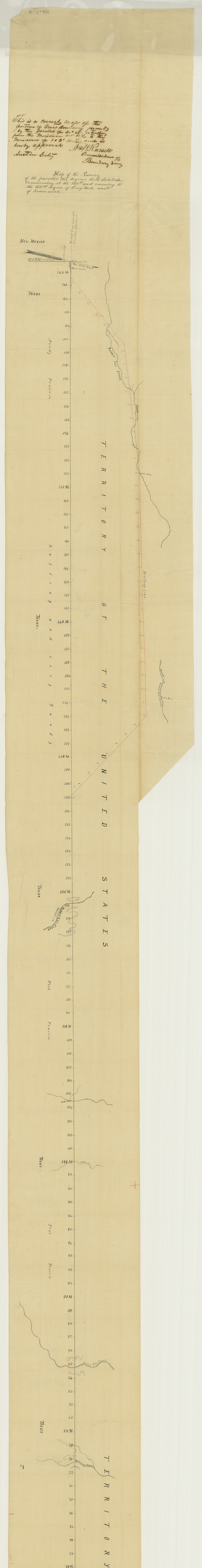
Map of the Survey of the Parallel 36 1/2 Degrees North Latitude, Commencing at the 100th and Running to the 103rd Degree of Longitude West of Greenwich
Print $40.00
- Digital $50.00
Map of the Survey of the Parallel 36 1/2 Degrees North Latitude, Commencing at the 100th and Running to the 103rd Degree of Longitude West of Greenwich
1862
Size 115.6 x 14.9 inches
Map/Doc 73566
Flight Mission No. CGI-1N, Frame 184, Cameron County

Print $20.00
- Digital $50.00
Flight Mission No. CGI-1N, Frame 184, Cameron County
1955
Size 18.5 x 22.2 inches
Map/Doc 84519
Map of the Country Upon Upper Red River Explored in 1852

Print $20.00
Map of the Country Upon Upper Red River Explored in 1852
1852
Size 17.2 x 34.9 inches
Map/Doc 79726
Current Miscellaneous File 111

Print $8.00
- Digital $50.00
Current Miscellaneous File 111
1996
Size 11.3 x 8.7 inches
Map/Doc 74714
Houston, Capital of Texas, 1837

Print $21.65
Houston, Capital of Texas, 1837
2007
Size 17.4 x 24.3 inches
Map/Doc 89272
Bandera County Working Sketch 46

Print $20.00
- Digital $50.00
Bandera County Working Sketch 46
1981
Size 28.0 x 37.4 inches
Map/Doc 67642