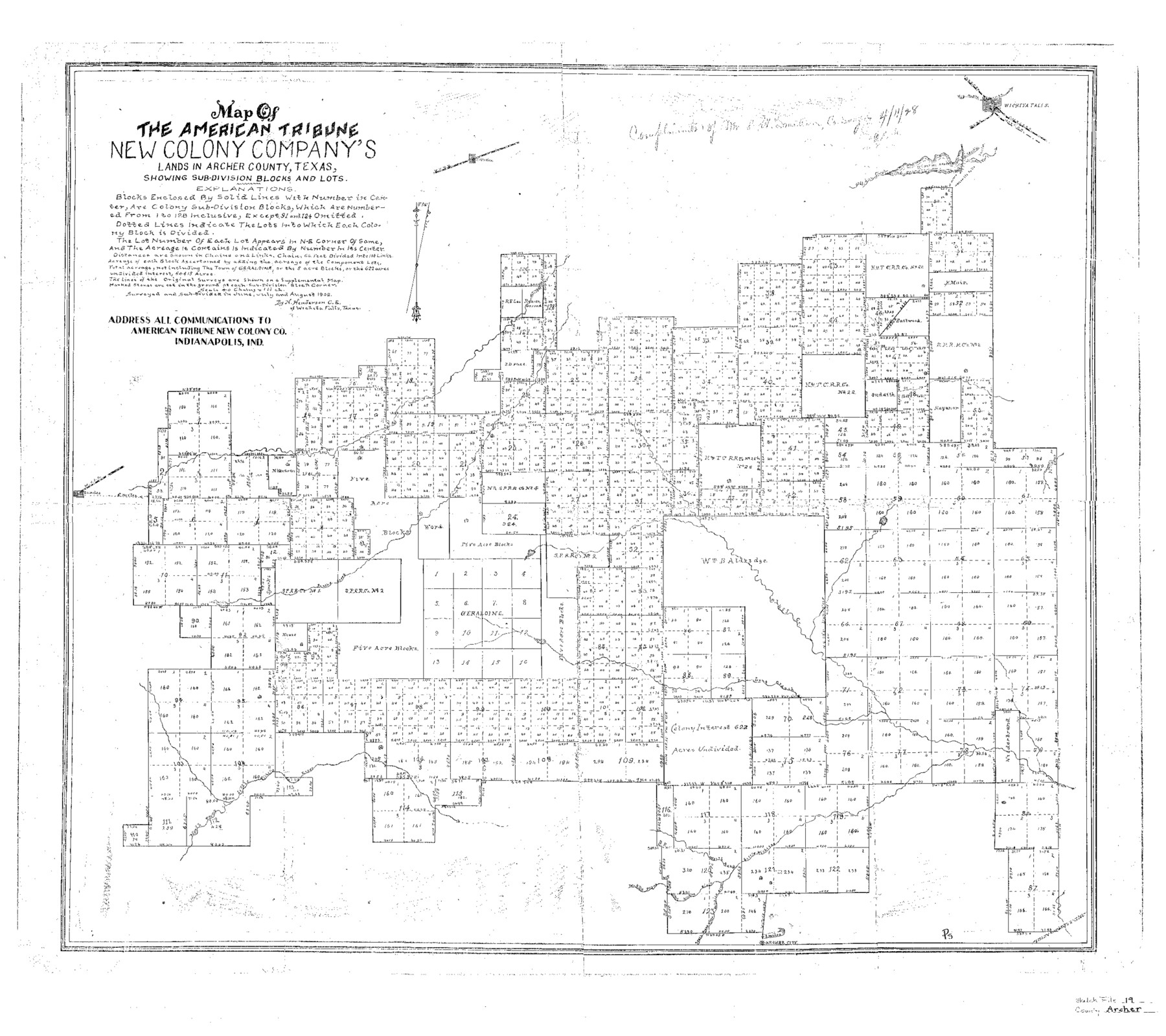
Archer County Sketch File 19
Map of the American Tribune New Colony Company's lands in Archer County, Texas, showing sub-division Blocks and Lots
-
Map/Doc
10829
-
Collection
General Map Collection
-
Object Dates
1928/4/11 (File Date)
1902 (Creation Date)
-
People and Organizations
N. Henderson (Surveyor/Engineer)
-
Counties
Archer
-
Subjects
Surveying Sketch File
-
Height x Width
23.8 x 26.8 inches
60.5 x 68.1 cm
-
Medium
paper, etching/engraving/lithograph
-
Features
Wichita Falls
Old Wichita River
Bluff Creek
Little Wichita River
Long Branch [of Little Wichita River]
North Prong of Little Wichita River
Middle Prong of Little Wichita River
South Prong of Little Wichita River
Archer City
Part of: General Map Collection
United States - Gulf Coast - Galveston to Rio Grande

Print $20.00
- Digital $50.00
United States - Gulf Coast - Galveston to Rio Grande
1919
Size 27.1 x 18.3 inches
Map/Doc 72745
Flight Mission No. CRC-4R, Frame 71, Chambers County

Print $20.00
- Digital $50.00
Flight Mission No. CRC-4R, Frame 71, Chambers County
1956
Size 18.7 x 22.5 inches
Map/Doc 84875
Coryelle County

Print $20.00
- Digital $50.00
Coryelle County
1855
Size 18.6 x 23.1 inches
Map/Doc 51904
Terry County Sketch File 7

Print $4.00
- Digital $50.00
Terry County Sketch File 7
1924
Size 11.2 x 9.1 inches
Map/Doc 38030
Flight Mission No. DCL-7C, Frame 145, Kenedy County

Print $20.00
- Digital $50.00
Flight Mission No. DCL-7C, Frame 145, Kenedy County
1943
Size 18.6 x 22.5 inches
Map/Doc 86102
Dimmit County Sketch File 58

Print $20.00
- Digital $50.00
Dimmit County Sketch File 58
1951
Size 18.0 x 9.8 inches
Map/Doc 11361
Dimmit County Working Sketch 22

Print $20.00
- Digital $50.00
Dimmit County Working Sketch 22
1951
Size 37.3 x 38.7 inches
Map/Doc 68683
Outer Continental Shelf Leasing Maps (Louisiana Offshore Operations)

Print $20.00
- Digital $50.00
Outer Continental Shelf Leasing Maps (Louisiana Offshore Operations)
1959
Size 17.8 x 14.1 inches
Map/Doc 76095
Jeff Davis County Rolled Sketch 20

Print $20.00
- Digital $50.00
Jeff Davis County Rolled Sketch 20
1944
Size 22.7 x 19.6 inches
Map/Doc 7724
Presidio County Rolled Sketch 83B

Print $20.00
- Digital $50.00
Presidio County Rolled Sketch 83B
Size 16.6 x 23.0 inches
Map/Doc 2061
Jefferson County Sketch File 45

Print $20.00
- Digital $50.00
Jefferson County Sketch File 45
1933
Size 16.7 x 33.0 inches
Map/Doc 11879
Flight Mission No. DQN-6K, Frame 9, Calhoun County

Print $20.00
- Digital $50.00
Flight Mission No. DQN-6K, Frame 9, Calhoun County
1953
Size 18.5 x 22.1 inches
Map/Doc 84431
You may also like
Panola County Sketch File 14

Print $4.00
- Digital $50.00
Panola County Sketch File 14
1873
Size 12.2 x 5.2 inches
Map/Doc 33472
Flight Mission No. DQO-1K, Frame 153, Galveston County

Print $20.00
- Digital $50.00
Flight Mission No. DQO-1K, Frame 153, Galveston County
1952
Size 18.8 x 22.5 inches
Map/Doc 85006
[Blocks GP and T]
![91509, [Blocks GP and T], Twichell Survey Records](https://historictexasmaps.com/wmedia_w700/maps/91509-1.tif.jpg)
Print $20.00
- Digital $50.00
[Blocks GP and T]
Size 26.0 x 24.6 inches
Map/Doc 91509
Castro County Sketch File 4f

Print $4.00
- Digital $50.00
Castro County Sketch File 4f
Size 13.8 x 8.9 inches
Map/Doc 17475
Kinney County Working Sketch 26

Print $40.00
- Digital $50.00
Kinney County Working Sketch 26
1953
Size 37.9 x 53.6 inches
Map/Doc 70208
![88951, Haskell Co[unty], Library of Congress](https://historictexasmaps.com/wmedia_w700/maps/88951.tif.jpg)
Section O Tech Memorial Park, Inc.

Print $20.00
- Digital $50.00
Section O Tech Memorial Park, Inc.
1950
Size 17.2 x 19.2 inches
Map/Doc 92299
Brewster County Rolled Sketch 26

Print $20.00
- Digital $50.00
Brewster County Rolled Sketch 26
Size 15.8 x 32.0 inches
Map/Doc 5214
Anderson County Working Sketch 1

Print $20.00
- Digital $50.00
Anderson County Working Sketch 1
Size 24.0 x 19.3 inches
Map/Doc 67000
Rusk County Working Sketch 36

Print $20.00
- Digital $50.00
Rusk County Working Sketch 36
2007
Size 31.7 x 36.0 inches
Map/Doc 83786
Polk County Sketch File 23

Print $20.00
- Digital $50.00
Polk County Sketch File 23
Size 18.0 x 18.6 inches
Map/Doc 12191
Andrews County Rolled Sketch 22

Print $20.00
- Digital $50.00
Andrews County Rolled Sketch 22
1946
Size 26.4 x 24.0 inches
Map/Doc 77170