Harrison County Sketch File 13
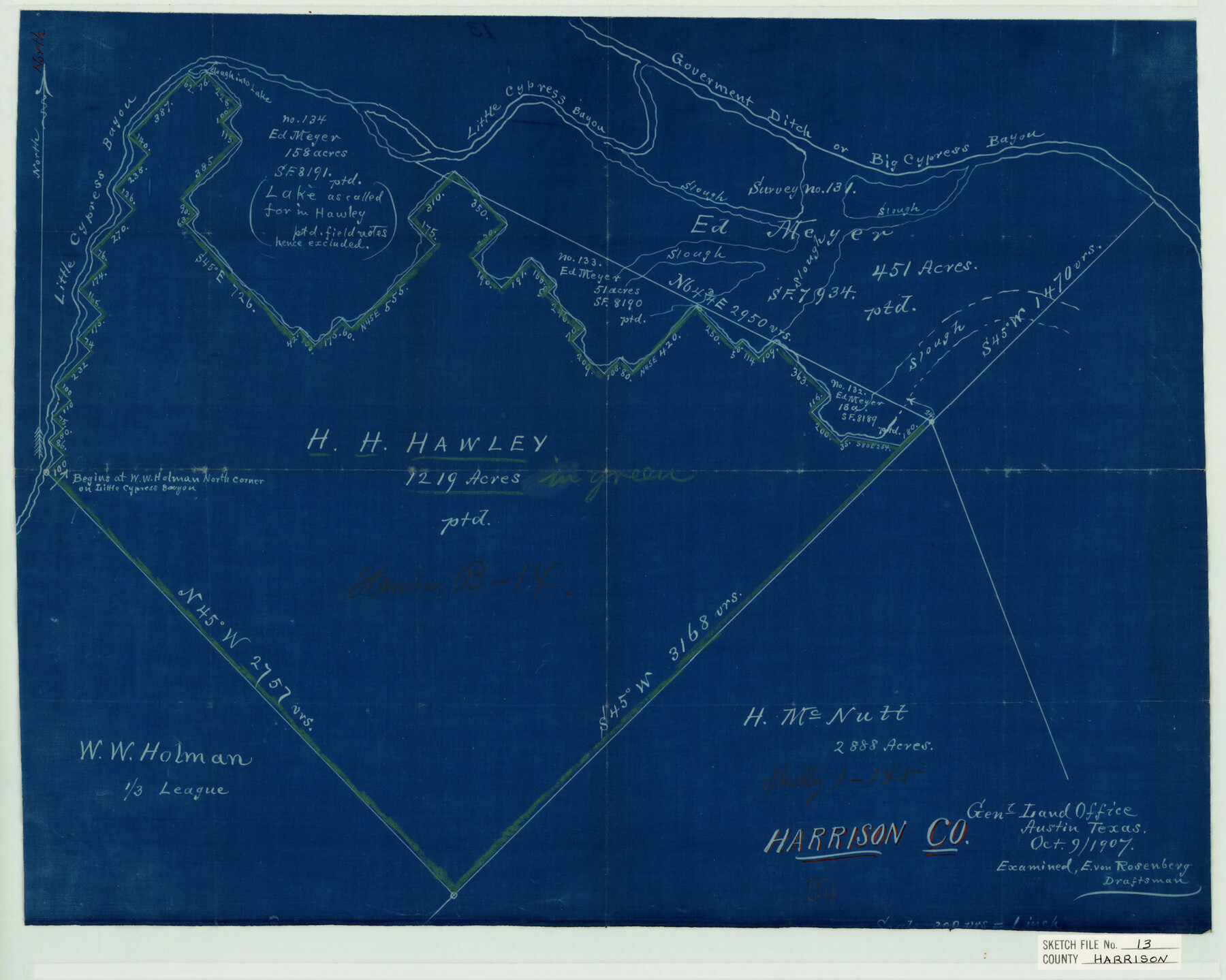
[Office sketch of the H.H. Hawley survey and surrounding surveys south of Little Cypress Bayou and northeast from Marshall]
-
Map/Doc
11688
-
Collection
General Map Collection
-
Object Dates
10/9/1907 (Creation Date)
-
People and Organizations
E. von Rosenberg (Draftsman)
-
Counties
Harrison
-
Subjects
Surveying Sketch File
-
Height x Width
15.2 x 19.0 inches
38.6 x 48.3 cm
-
Medium
blueprint/diazo
-
Scale
1" = 200 varas
-
Features
Little Cypress Bayou
Little Cypress Bayou
Government Ditch
Part of: General Map Collection
Goliad County Working Sketch 17

Print $20.00
- Digital $50.00
Goliad County Working Sketch 17
1949
Size 21.8 x 22.2 inches
Map/Doc 63207
Hays County Sketch File 9

Print $6.00
- Digital $50.00
Hays County Sketch File 9
Size 9.6 x 16.2 inches
Map/Doc 26212
Sherman County Boundary File Index

Print $2.00
- Digital $50.00
Sherman County Boundary File Index
Size 8.8 x 13.2 inches
Map/Doc 58750
Morris County Rolled Sketch 2A

Print $20.00
- Digital $50.00
Morris County Rolled Sketch 2A
Size 24.4 x 19.2 inches
Map/Doc 10271
Crockett County Working Sketch 77

Print $40.00
- Digital $50.00
Crockett County Working Sketch 77
1966
Size 29.6 x 58.5 inches
Map/Doc 68410
Gillespie County Boundary File 5a

Print $2.00
- Digital $50.00
Gillespie County Boundary File 5a
Size 8.3 x 7.9 inches
Map/Doc 53769
Culberson County Sketch File 3

Print $58.00
- Digital $50.00
Culberson County Sketch File 3
Size 8.0 x 3.3 inches
Map/Doc 20112
Brazoria County Rolled Sketch 42

Print $20.00
- Digital $50.00
Brazoria County Rolled Sketch 42
1962
Size 35.0 x 44.5 inches
Map/Doc 8461
Ward County Rolled Sketch A

Print $40.00
- Digital $50.00
Ward County Rolled Sketch A
Size 42.6 x 56.3 inches
Map/Doc 10099
Loving County Working Sketch 25

Print $40.00
- Digital $50.00
Loving County Working Sketch 25
1952
Size 49.6 x 22.1 inches
Map/Doc 70659
Dawson County Rolled Sketch 13

Print $20.00
- Digital $50.00
Dawson County Rolled Sketch 13
1951
Size 18.9 x 25.4 inches
Map/Doc 5696
Crockett County Sketch File 58a

Print $20.00
- Digital $50.00
Crockett County Sketch File 58a
1923
Size 21.1 x 25.8 inches
Map/Doc 5601
You may also like
[Surveys in Henderson County, Nacogdoches/Houston District]
![69735, [Surveys in Henderson County, Nacogdoches/Houston District], General Map Collection](https://historictexasmaps.com/wmedia_w700/maps/69735.tif.jpg)
Print $2.00
- Digital $50.00
[Surveys in Henderson County, Nacogdoches/Houston District]
Size 11.0 x 7.9 inches
Map/Doc 69735
Trinity River, Wire Bridge Sheet/Denton Creek

Print $6.00
- Digital $50.00
Trinity River, Wire Bridge Sheet/Denton Creek
1938
Size 30.4 x 29.7 inches
Map/Doc 65244
Flight Mission No. DQO-11K, Frame 23, Galveston County

Print $20.00
- Digital $50.00
Flight Mission No. DQO-11K, Frame 23, Galveston County
1952
Size 18.8 x 22.4 inches
Map/Doc 85220
[Surveys along Green's Creek and the North Bosque River]
![69756, [Surveys along Green's Creek and the North Bosque River], General Map Collection](https://historictexasmaps.com/wmedia_w700/maps/69756.tif.jpg)
Print $2.00
- Digital $50.00
[Surveys along Green's Creek and the North Bosque River]
1846
Size 11.9 x 8.1 inches
Map/Doc 69756
University of Texas System University Lands

Print $20.00
- Digital $50.00
University of Texas System University Lands
1936
Size 23.2 x 17.6 inches
Map/Doc 93236
Lamb County Working Sketch 3

Print $20.00
- Digital $50.00
Lamb County Working Sketch 3
1962
Size 32.1 x 37.7 inches
Map/Doc 70276
Loving County Rolled Sketch 14

Print $20.00
- Digital $50.00
Loving County Rolled Sketch 14
2006
Size 11.4 x 17.5 inches
Map/Doc 93381
Hays County State Real Property Sketch 3

Print $20.00
- Digital $50.00
Hays County State Real Property Sketch 3
2003
Size 24.0 x 37.2 inches
Map/Doc 96638
[Surveys in Austin's Colony along Hickory Creek, Hog Creek, and the Yegua River]
![195, [Surveys in Austin's Colony along Hickory Creek, Hog Creek, and the Yegua River], General Map Collection](https://historictexasmaps.com/wmedia_w700/maps/195.tif.jpg)
Print $20.00
- Digital $50.00
[Surveys in Austin's Colony along Hickory Creek, Hog Creek, and the Yegua River]
1831
Size 19.4 x 23.9 inches
Map/Doc 195
Bastrop County Sketch File 9

Print $40.00
- Digital $50.00
Bastrop County Sketch File 9
1943
Size 46.5 x 20.6 inches
Map/Doc 10320
Colorado County Sketch File 31

Print $4.00
- Digital $50.00
Colorado County Sketch File 31
1838
Size 12.8 x 7.8 inches
Map/Doc 18984
Flight Mission No. CUG-1P, Frame 111, Kleberg County

Print $20.00
- Digital $50.00
Flight Mission No. CUG-1P, Frame 111, Kleberg County
1956
Size 18.5 x 22.2 inches
Map/Doc 86161