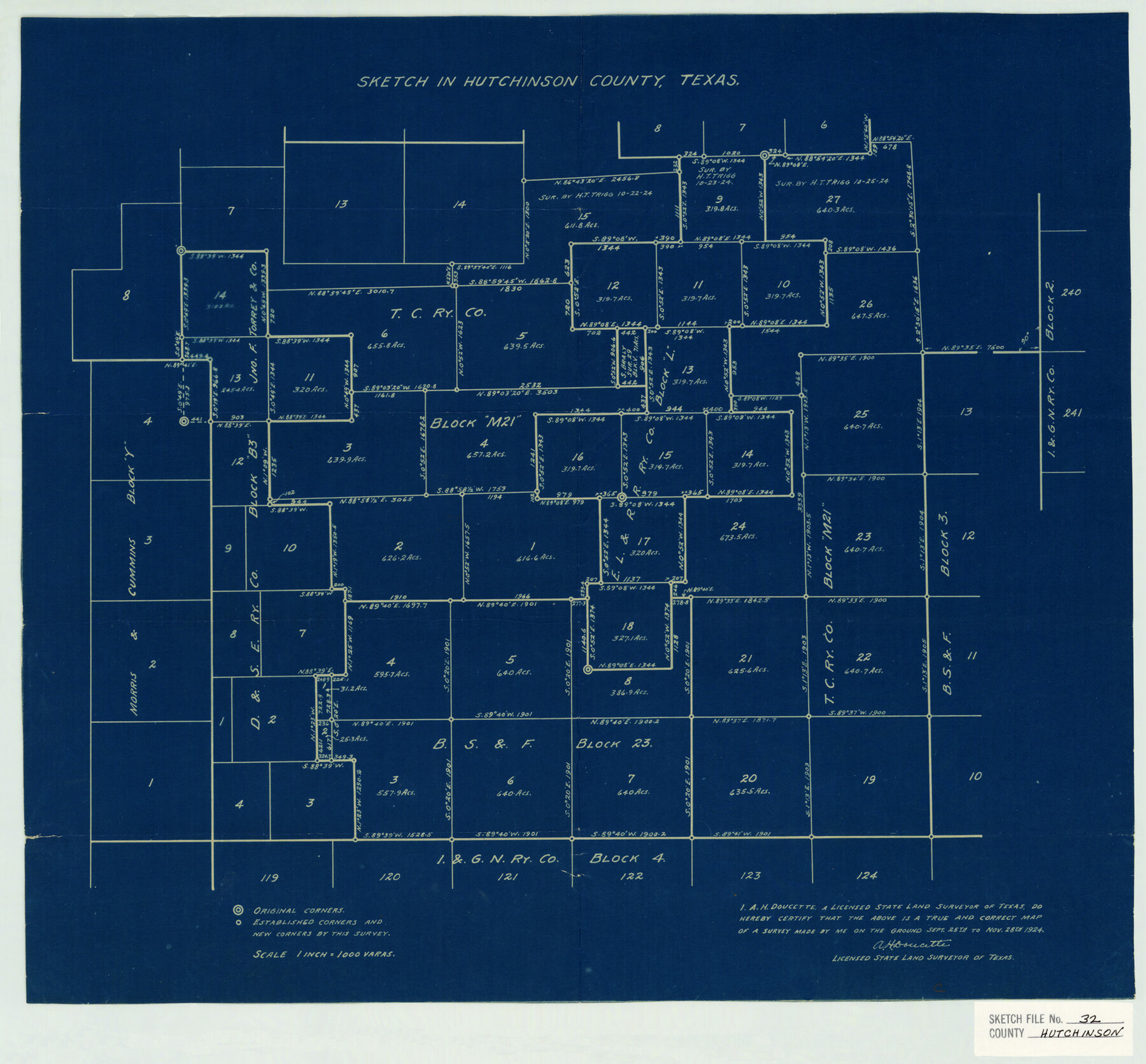
Hutchinson County Sketch File 32
A. H. Doucett's Sk. of parts of Blks. M-21, 4, 23, Y. & C.
-
Map/Doc
11820
-
Collection
General Map Collection
-
Object Dates
11/28/1924 (Creation Date)
3/26/1926 (File Date)
9/25/1924 (Survey Date)
11/28/1924 (Survey Date)
-
People and Organizations
A.H. Doucette (Surveyor/Engineer)
-
Counties
Hutchinson
-
Subjects
Surveying Sketch File
-
Height x Width
16.7 x 18.0 inches
42.4 x 45.7 cm
-
Medium
blueprint/diazo
Part of: General Map Collection
Map of Parmer County

Print $20.00
- Digital $50.00
Map of Parmer County
1900
Size 47.8 x 41.3 inches
Map/Doc 16786
Flight Mission No. BRA-7M, Frame 182, Jefferson County

Print $20.00
- Digital $50.00
Flight Mission No. BRA-7M, Frame 182, Jefferson County
1953
Size 18.5 x 22.3 inches
Map/Doc 85550
Sherman County Sketch File 1

Print $20.00
- Digital $50.00
Sherman County Sketch File 1
1923
Size 25.3 x 25.4 inches
Map/Doc 12322
Bastrop County

Print $20.00
- Digital $50.00
Bastrop County
1879
Size 21.5 x 19.5 inches
Map/Doc 3277
Orange County NRC Article 33.136 Location Key Sheet

Print $20.00
- Digital $50.00
Orange County NRC Article 33.136 Location Key Sheet
1974
Size 27.0 x 23.0 inches
Map/Doc 87911
Red River County Rolled Sketch 10

Print $20.00
- Digital $50.00
Red River County Rolled Sketch 10
2005
Size 35.8 x 35.6 inches
Map/Doc 83316
Map of Maverick County

Print $20.00
- Digital $50.00
Map of Maverick County
1878
Size 33.4 x 20.6 inches
Map/Doc 3850
Castro County Sketch File 18

Print $20.00
- Digital $50.00
Castro County Sketch File 18
1988
Size 40.4 x 37.7 inches
Map/Doc 10330
Padre Island, Register No. 1485a

Print $40.00
- Digital $50.00
Padre Island, Register No. 1485a
1881
Size 55.7 x 36.7 inches
Map/Doc 73609
Camp County Working Sketch 1

Print $20.00
- Digital $50.00
Camp County Working Sketch 1
1970
Size 32.9 x 29.7 inches
Map/Doc 67877
Andrews County Rolled Sketch 26

Print $40.00
- Digital $50.00
Andrews County Rolled Sketch 26
1948
Size 78.3 x 13.2 inches
Map/Doc 8398
Pecos County Sketch File 75

Print $6.00
- Digital $50.00
Pecos County Sketch File 75
1943
Size 11.3 x 8.9 inches
Map/Doc 33904
You may also like
Nolan County Working Sketch 1

Print $20.00
- Digital $50.00
Nolan County Working Sketch 1
1928
Size 17.9 x 17.5 inches
Map/Doc 71292
Intracoastal Waterway in Texas - Corpus Christi to Point Isabel including Arroyo Colorado to Mo. Pac. R.R. Bridge Near Harlingen

Print $20.00
- Digital $50.00
Intracoastal Waterway in Texas - Corpus Christi to Point Isabel including Arroyo Colorado to Mo. Pac. R.R. Bridge Near Harlingen
1933
Size 28.1 x 41.0 inches
Map/Doc 61844
Aransas County Sketch File 27

Print $23.00
- Digital $50.00
Aransas County Sketch File 27
Size 12.2 x 18.2 inches
Map/Doc 13224

Bee County Working Sketch 16

Print $20.00
- Digital $50.00
Bee County Working Sketch 16
1974
Size 18.0 x 19.6 inches
Map/Doc 67266
El Paso County Rolled Sketch 63

Print $20.00
- Digital $50.00
El Paso County Rolled Sketch 63
1996
Size 24.7 x 36.8 inches
Map/Doc 5855
Kendall County Boundary File 3a

Print $8.00
- Digital $50.00
Kendall County Boundary File 3a
Size 11.2 x 8.9 inches
Map/Doc 55765
[Location, Fort Worth & Denver Railroad, through Wilbarger County]
![64344, [Location, Fort Worth & Denver Railroad, through Wilbarger County], General Map Collection](https://historictexasmaps.com/wmedia_w700/maps/64344.tif.jpg)
Print $40.00
- Digital $50.00
[Location, Fort Worth & Denver Railroad, through Wilbarger County]
Size 20.8 x 123.5 inches
Map/Doc 64344
Haskell County Sketch File 25

Print $20.00
- Digital $50.00
Haskell County Sketch File 25
1888
Size 16.8 x 21.8 inches
Map/Doc 11748
[Sketch showing San Augustine, Morris, Stephens and Eastland School Land Leagues and adjacent Blocks]
![89918, [Sketch showing San Augustine, Morris, Stephens and Eastland School Land Leagues and adjacent Blocks], Twichell Survey Records](https://historictexasmaps.com/wmedia_w700/maps/89918-1.tif.jpg)
Print $40.00
- Digital $50.00
[Sketch showing San Augustine, Morris, Stephens and Eastland School Land Leagues and adjacent Blocks]
Size 54.7 x 43.5 inches
Map/Doc 89918

Titus County Sketch File 6

Print $6.00
- Digital $50.00
Titus County Sketch File 6
1853
Size 16.5 x 8.3 inches
Map/Doc 38140