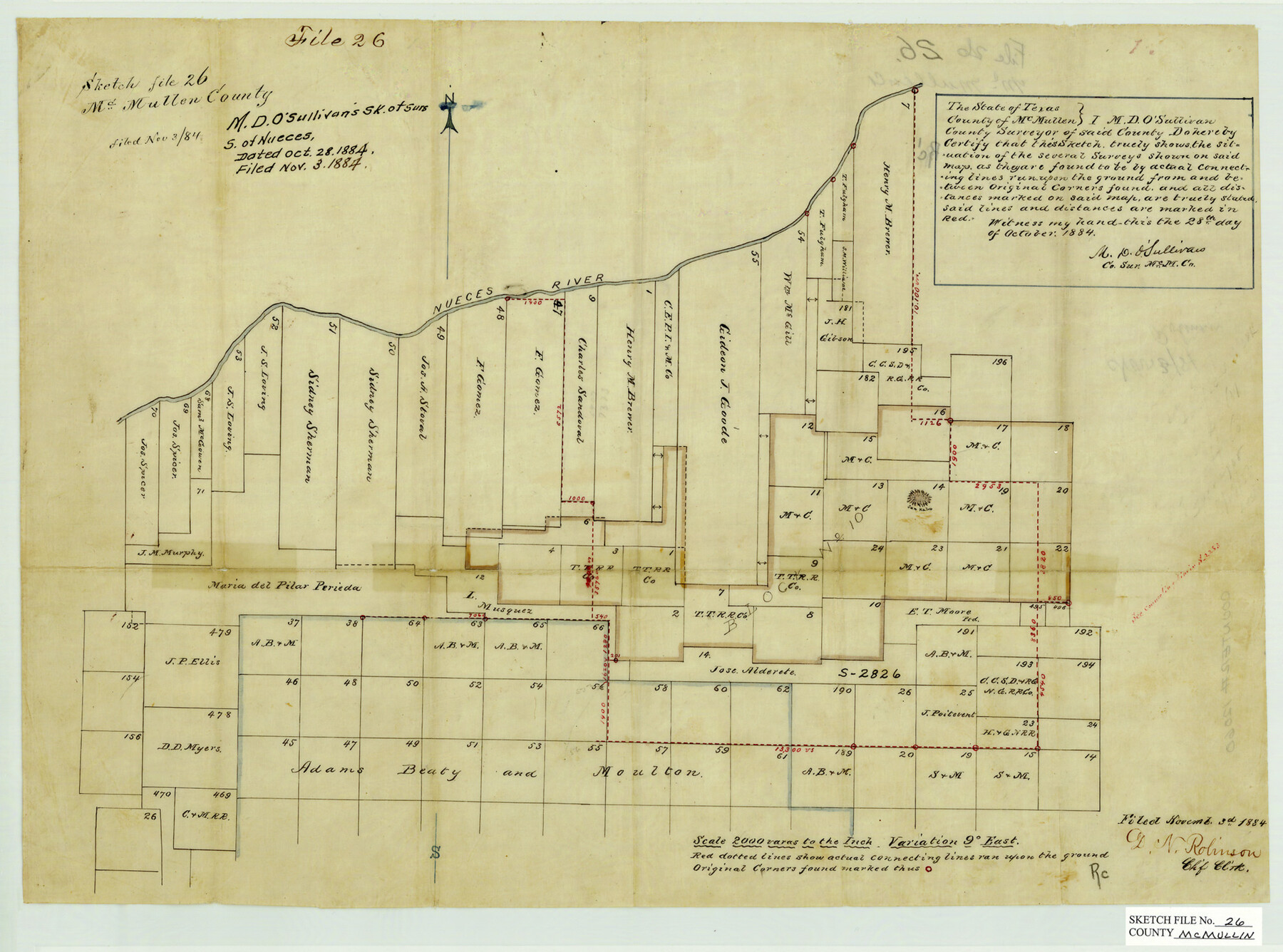
McMullen County Sketch File 26
Sketch of Surveys South of the Nueces River, McMullen County, Texas
-
Map/Doc
12060
-
Collection
General Map Collection
-
Object Dates
1884/10/28 (Creation Date)
1884/11/3 (File Date)
-
People and Organizations
M.D. O'Sullivan (Surveyor/Engineer)
-
Counties
McMullen Live Oak
-
Subjects
Surveying Sketch File
-
Height x Width
14.7 x 19.8 inches
37.3 x 50.3 cm
-
Medium
paper, manuscript
-
Features
Nueces River
San Kaho
Part of: General Map Collection

Lampasas County Sketch File 2

Print $40.00
- Digital $50.00
Lampasas County Sketch File 2
1858
Size 15.6 x 12.7 inches
Map/Doc 29390
Colorado River, Lane City Sheet

Print $4.00
- Digital $50.00
Colorado River, Lane City Sheet
1941
Size 27.0 x 29.9 inches
Map/Doc 65316
Map of Colorado County

Print $20.00
- Digital $50.00
Map of Colorado County
1880
Size 21.8 x 21.1 inches
Map/Doc 3426
Ward County Working Sketch 21

Print $20.00
- Digital $50.00
Ward County Working Sketch 21
1953
Size 20.9 x 14.7 inches
Map/Doc 72327
McMullen County Working Sketch 39

Print $40.00
- Digital $50.00
McMullen County Working Sketch 39
1975
Size 53.3 x 31.7 inches
Map/Doc 70740
Nueces County Sketch File 66

Print $18.00
- Digital $50.00
Nueces County Sketch File 66
1981
Size 14.3 x 8.8 inches
Map/Doc 32989
Plat of Division 3 of Day Ranch Lands, Leaday, Texas

Print $20.00
- Digital $50.00
Plat of Division 3 of Day Ranch Lands, Leaday, Texas
Size 20.4 x 21.8 inches
Map/Doc 81514
Ward County Working Sketch 28

Print $40.00
- Digital $50.00
Ward County Working Sketch 28
1964
Size 60.9 x 29.1 inches
Map/Doc 72334
Aransas County Rolled Sketch 2

Print $40.00
- Digital $50.00
Aransas County Rolled Sketch 2
1950
Size 42.5 x 48.6 inches
Map/Doc 73611

[Surveys in the Bexar District along the Atascosa Creek]
![221, [Surveys in the Bexar District along the Atascosa Creek], General Map Collection](https://historictexasmaps.com/wmedia_w700/maps/221.tif.jpg)
Print $2.00
- Digital $50.00
[Surveys in the Bexar District along the Atascosa Creek]
1842
Size 5.9 x 5.9 inches
Map/Doc 221
You may also like
Bexar County Working Sketch 17

Print $20.00
- Digital $50.00
Bexar County Working Sketch 17
1978
Size 22.8 x 34.2 inches
Map/Doc 67333
Webb County Sketch File 19

Print $15.00
- Digital $50.00
Webb County Sketch File 19
1902
Size 9.2 x 17.0 inches
Map/Doc 39822
[Blocks S and M19 Resurvey]
![91440, [Blocks S and M19 Resurvey], Twichell Survey Records](https://historictexasmaps.com/wmedia_w700/maps/91440-1.tif.jpg)
Print $20.00
- Digital $50.00
[Blocks S and M19 Resurvey]
1903
Size 37.0 x 30.0 inches
Map/Doc 91440
Bastrop County Working Sketch 13

Print $20.00
- Digital $50.00
Bastrop County Working Sketch 13
1979
Size 23.6 x 30.0 inches
Map/Doc 67313
Montgomery County Sketch File 8

Print $4.00
- Digital $50.00
Montgomery County Sketch File 8
1862
Size 12.2 x 8.2 inches
Map/Doc 31793
Texas Official Highway Travel Map

Digital $50.00
Texas Official Highway Travel Map
Size 27.3 x 36.3 inches
Map/Doc 94306

Pecos County Rolled Sketch 188

Print $40.00
- Digital $50.00
Pecos County Rolled Sketch 188
1984
Size 59.4 x 43.5 inches
Map/Doc 9753
Ward County Working Sketch 3

Print $20.00
- Digital $50.00
Ward County Working Sketch 3
1935
Size 24.1 x 27.1 inches
Map/Doc 72309
[T. & G. Ry. Main Line, Texas, Right of Way Map, Center to Gary]
![64572, [T. & G. Ry. Main Line, Texas, Right of Way Map, Center to Gary], General Map Collection](https://historictexasmaps.com/wmedia_w700/maps/64572-1.tif.jpg)
Print $40.00
- Digital $50.00
[T. & G. Ry. Main Line, Texas, Right of Way Map, Center to Gary]
1917
Size 31.9 x 104.6 inches
Map/Doc 64572
Cooke County Working Sketch 2

Print $20.00
- Digital $50.00
Cooke County Working Sketch 2
1925
Size 22.2 x 10.9 inches
Map/Doc 68239
Bird's Eye View of the City of Brenham, Washington County, Texas

Print $20.00
Bird's Eye View of the City of Brenham, Washington County, Texas
1881
Size 19.4 x 26.7 inches
Map/Doc 89076