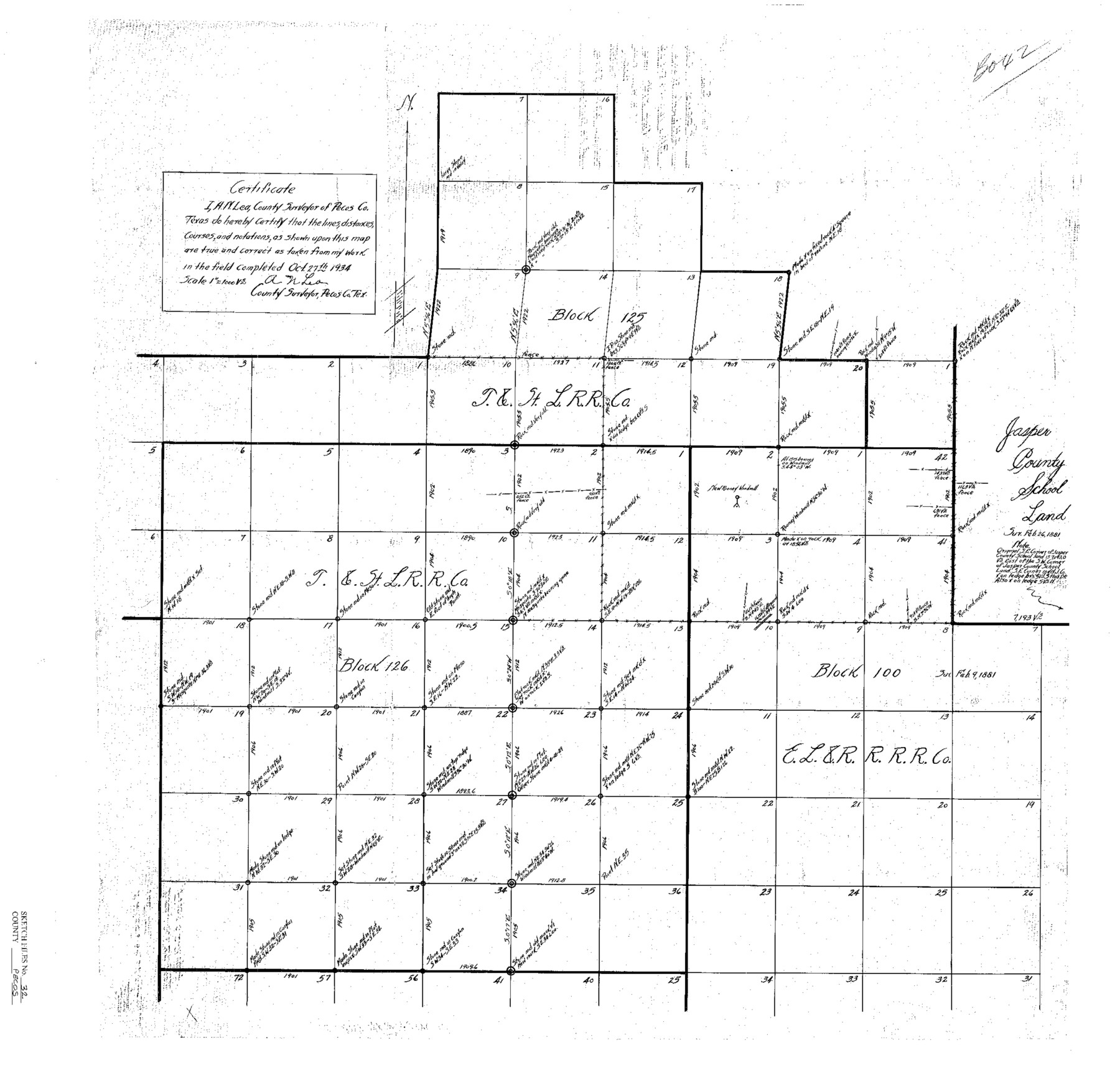
Pecos County Sketch File 32
Sketch of Blocks 100, 125 & 126, Pecos County, Texas
-
Map/Doc
12175
-
Collection
General Map Collection
-
Object Dates
1934/10/27 (Creation Date)
1934/10/31 (File Date)
1934/10/27 (Survey Date)
-
People and Organizations
A.N. Lea (Surveyor/Engineer)
-
Counties
Pecos
-
Subjects
Surveying Sketch File
-
Height x Width
23.2 x 24.3 inches
58.9 x 61.7 cm
-
Medium
paper, print
-
Scale
1" = 1000 varas
Part of: General Map Collection
Dallas County Boundary File 6g

Print $6.00
- Digital $50.00
Dallas County Boundary File 6g
Size 11.2 x 8.7 inches
Map/Doc 52275
Flight Mission No. DQO-8K, Frame 133, Galveston County

Print $20.00
- Digital $50.00
Flight Mission No. DQO-8K, Frame 133, Galveston County
1952
Size 18.8 x 22.5 inches
Map/Doc 85198
Bowie County Sketch File 7

Print $40.00
- Digital $50.00
Bowie County Sketch File 7
1927
Size 18.0 x 35.5 inches
Map/Doc 10943
Texas, Corpus Christi, Corpus Christi to Laguna Madre

Print $40.00
- Digital $50.00
Texas, Corpus Christi, Corpus Christi to Laguna Madre
1934
Size 35.1 x 48.6 inches
Map/Doc 73457
Presidio County Sketch File 54

Print $4.00
- Digital $50.00
Presidio County Sketch File 54
Size 14.3 x 8.8 inches
Map/Doc 34620
Baylor County Rolled Sketch 9A

Print $20.00
- Digital $50.00
Baylor County Rolled Sketch 9A
1892
Size 16.0 x 24.6 inches
Map/Doc 5126
Crockett County Working Sketch 55

Print $40.00
- Digital $50.00
Crockett County Working Sketch 55
1951
Size 51.0 x 37.5 inches
Map/Doc 68388
Harrison County Working Sketch 30

Print $20.00
- Digital $50.00
Harrison County Working Sketch 30
2001
Size 29.5 x 31.9 inches
Map/Doc 66050
Wichita County Sketch File 11

Print $10.00
- Digital $50.00
Wichita County Sketch File 11
1880
Size 8.3 x 7.7 inches
Map/Doc 40056
Menard County Working Sketch 27

Print $20.00
- Digital $50.00
Menard County Working Sketch 27
1962
Size 38.2 x 43.8 inches
Map/Doc 70974
Hardeman County Working Sketch 7

Print $20.00
- Digital $50.00
Hardeman County Working Sketch 7
1952
Size 34.2 x 30.9 inches
Map/Doc 63388
Right-of-Way and Track Map, Houston and Brazos Valley Ry. Co. operated by the Houston and Brazos Valley Ry. Co.

Print $40.00
- Digital $50.00
Right-of-Way and Track Map, Houston and Brazos Valley Ry. Co. operated by the Houston and Brazos Valley Ry. Co.
1918
Size 24.9 x 56.6 inches
Map/Doc 64606
You may also like

The great railroad routes to the Pacific, and their connections

Print $20.00
- Digital $50.00
The great railroad routes to the Pacific, and their connections
1869
Size 16.3 x 29.4 inches
Map/Doc 96974
[Texas Gulf Coast]
![72678, [Texas Gulf Coast], General Map Collection](https://historictexasmaps.com/wmedia_w700/maps/72678.tif.jpg)
Print $20.00
- Digital $50.00
[Texas Gulf Coast]
Size 18.3 x 27.6 inches
Map/Doc 72678
Map of Texas. The Proposed Reoccupation of the Rio Grande -- Its Importance to the Union

Print $20.00
Map of Texas. The Proposed Reoccupation of the Rio Grande -- Its Importance to the Union
1965
Size 14.1 x 8.6 inches
Map/Doc 76264
[Sketch showing I. G. Yates SF 12341 and surrounding surveys]
![93106, [Sketch showing I. G. Yates SF 12341 and surrounding surveys], Twichell Survey Records](https://historictexasmaps.com/wmedia_w700/maps/93106-1.tif.jpg)
Print $20.00
- Digital $50.00
[Sketch showing I. G. Yates SF 12341 and surrounding surveys]
Size 25.9 x 21.6 inches
Map/Doc 93106
Burleson County Working Sketch 29

Print $20.00
- Digital $50.00
Burleson County Working Sketch 29
1981
Size 24.7 x 24.7 inches
Map/Doc 67748
Stephens County Working Sketch 25

Print $20.00
- Digital $50.00
Stephens County Working Sketch 25
1976
Size 37.4 x 32.3 inches
Map/Doc 63968
Pecos County Working Sketch 95

Print $20.00
- Digital $50.00
Pecos County Working Sketch 95
1970
Size 42.6 x 40.6 inches
Map/Doc 71568
[Capitol lands granted for purpose of building State Capitol]
![2073, [Capitol lands granted for purpose of building State Capitol], General Map Collection](https://historictexasmaps.com/wmedia_w700/maps/2073.tif.jpg)
Print $20.00
- Digital $50.00
[Capitol lands granted for purpose of building State Capitol]
1956
Size 31.5 x 13.0 inches
Map/Doc 2073
Garza County Working Sketch 6

Print $20.00
- Digital $50.00
Garza County Working Sketch 6
1944
Size 24.8 x 20.2 inches
Map/Doc 63153
[Blk. M, T. & P. Blocks 33-36, Townships 5N and 6N]
![90549, [Blk. M, T. & P. Blocks 33-36, Townships 5N and 6N], Twichell Survey Records](https://historictexasmaps.com/wmedia_w700/maps/90549-1.tif.jpg)
Print $20.00
- Digital $50.00
[Blk. M, T. & P. Blocks 33-36, Townships 5N and 6N]
Size 16.2 x 12.2 inches
Map/Doc 90549
Hockley County Sketch, Mineral Application Number 38245

Print $20.00
- Digital $50.00
Hockley County Sketch, Mineral Application Number 38245
Size 27.2 x 10.8 inches
Map/Doc 91093