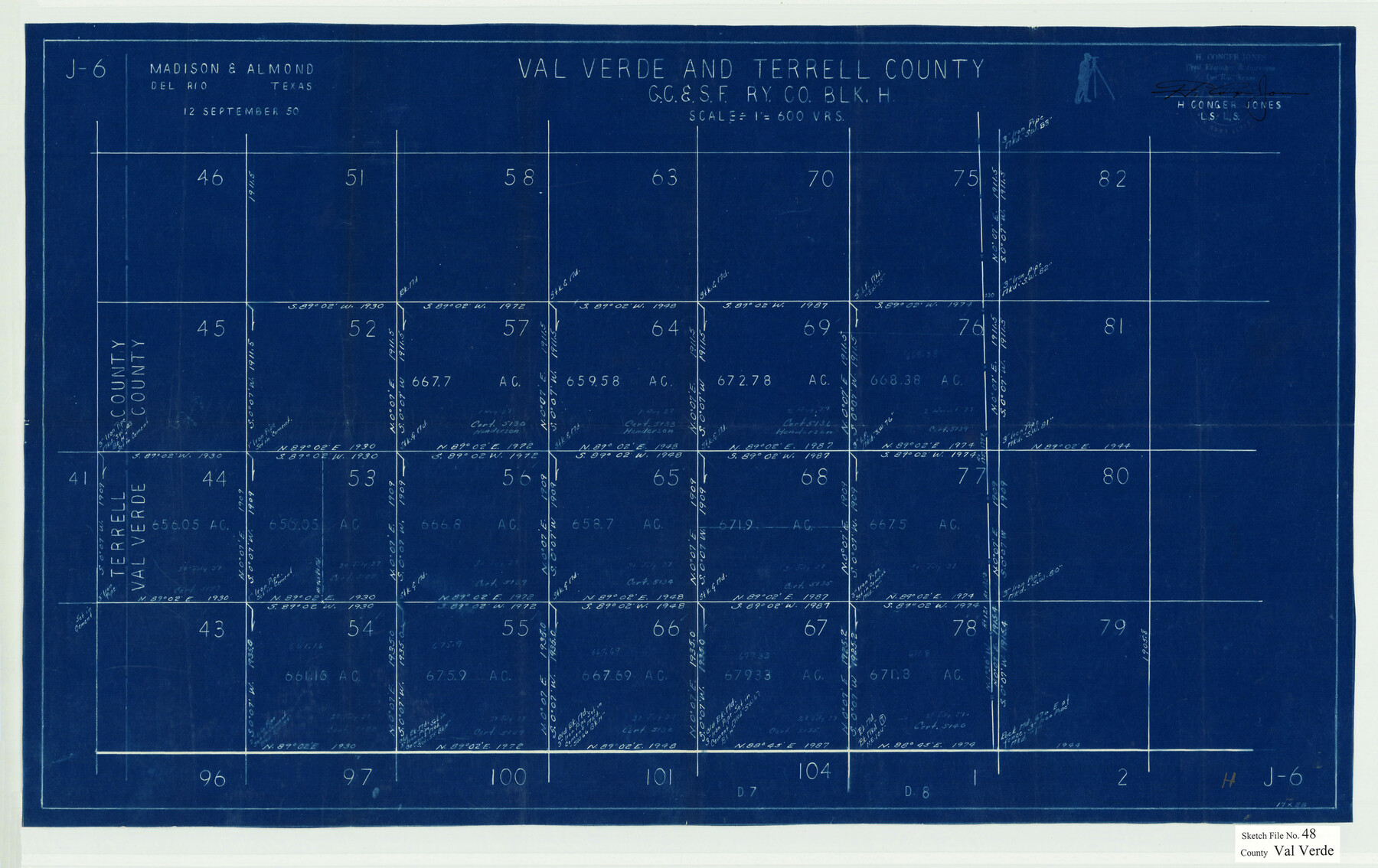
Val Verde County Sketch File 48
[Sketch of a part of G. C. & S. F. Ry. Co. Block H in Val Verde and Terrell Counties]
- 
                          Map/Doc12589
- 
                            CollectionGeneral Map Collection
- 
                            Object Dates9/12/1950 (Creation Date)10/19/1950 (File Date)
- 
                            People and OrganizationsH. Conger Jones (Surveyor/Engineer)
- 
                            CountiesVal Verde Terrell
- 
                            SubjectsSurveying Sketch File
- 
                            Height x Width18.2 x 28.9 inches46.2 x 73.4 cm
- 
                            Mediumblueprint/diazo
- 
                            Scale1" = 600 varas
Part of: General Map Collection
            Copy of Surveyor's Field Book, Morris Browning - In Blocks 7, 5 & 4, I&GNRRCo., Hutchinson and Carson Counties, Texas


                                            Print $3.00                    
                                             -                         Digital $50.00                                    
                Copy of Surveyor's Field Book, Morris Browning - In Blocks 7, 5 & 4, I&GNRRCo., Hutchinson and Carson Counties, Texas
1888
Size 12.7 x 9.7 inches
                                Map/Doc 62258
            
            San Augustine County Working Sketch 26


                                            Print $40.00                    
                                             -                         Digital $50.00                                    
                San Augustine County Working Sketch 26
2008
Size 63.9 x 33.5 inches
                                Map/Doc 88823
            
            Webb County Sketch File 58


                                            Print $10.00                    
                                             -                         Digital $50.00                                    
                Webb County Sketch File 58
1942
Size 14.4 x 8.9 inches
                                Map/Doc 39846
            
            Gulf Oil Corp. Fishgide - Port O'Connor


            Gulf Oil Corp. Fishgide - Port O'Connor
1960
Size 12.0 x 22.0 inches
                                Map/Doc 75982
            
            Karnes County Boundary File 4


                                            Print $14.00                    
                                             -                         Digital $50.00                                    
                Karnes County Boundary File 4
Size 12.7 x 8.2 inches
                                Map/Doc 55698
            
            Township No. 5 South, Range No. 14 West, Indian Meridian, Oklahoma


                                            Print $4.00                    
                                             -                         Digital $50.00                                    
                Township No. 5 South, Range No. 14 West, Indian Meridian, Oklahoma
1928
Size 18.0 x 22.6 inches
                                Map/Doc 75141
            
            Map of Presidio County, Texas


                                            Print $40.00                    
                                             -                         Digital $50.00                                    
                Map of Presidio County, Texas
Size 42.6 x 86.0 inches
                                Map/Doc 76071
            
            Harris County Historic Topographic 28


                                            Print $20.00                    
                                             -                         Digital $50.00                                    
                Harris County Historic Topographic 28
1915
Size 29.5 x 22.8 inches
                                Map/Doc 65839
            
            Flight Mission No. DQN-1K, Frame 50, Calhoun County


                                            Print $20.00                    
                                             -                         Digital $50.00                                    
                Flight Mission No. DQN-1K, Frame 50, Calhoun County
1953
Size 18.7 x 22.3 inches
                                Map/Doc 84150
            
            Rosebud Station Map -Tracks and Structures - Lands, San Antonio and Aransas Pass Railway Co


                                            Print $4.00                    
                                             -                         Digital $50.00                                    
                Rosebud Station Map -Tracks and Structures - Lands, San Antonio and Aransas Pass Railway Co
1919
Size 11.7 x 18.6 inches
                                Map/Doc 62565
            
            Flight Mission No. BRE-2P, Frame 64, Nueces County


                                            Print $20.00                    
                                             -                         Digital $50.00                                    
                Flight Mission No. BRE-2P, Frame 64, Nueces County
1956
Size 18.5 x 22.6 inches
                                Map/Doc 86759
            
            Uvalde County Sketch File 18


                                            Print $6.00                    
                                             -                         Digital $50.00                                    
                Uvalde County Sketch File 18
1883
Size 10.9 x 8.2 inches
                                Map/Doc 38997
            You may also like
            [Sketch of Surveys on Big Sandy Creek]
            
                                    ![179, [Sketch of Surveys on Big Sandy Creek], General Map Collection](https://historictexasmaps.com/wmedia_w700/maps/179.tif.jpg) 


    ![179, [Sketch of Surveys on Big Sandy Creek], General Map Collection](https://historictexasmaps.com/wmedia_w700/maps/179.tif.jpg) 
                                
            
                                            Print $2.00                    
                                             -                         Digital $50.00                                    
                [Sketch of Surveys on Big Sandy Creek]
1841
Size 8.2 x 9.2 inches
                                Map/Doc 179
            
            Coke County Working Sketch 13


                                            Print $20.00                    
                                             -                         Digital $50.00                                    
                Coke County Working Sketch 13
1947
Size 47.0 x 44.5 inches
                                Map/Doc 68050
            
            Refugio County Working Sketch 17


                                            Print $20.00                    
                                             -                         Digital $50.00                                    
                Refugio County Working Sketch 17
1980
Size 17.7 x 30.1 inches
                                Map/Doc 63526
            
            Hunt County Rolled Sketch 3


                                            Print $20.00                    
                                             -                         Digital $50.00                                    
                Hunt County Rolled Sketch 3
Size 19.1 x 36.0 inches
                                Map/Doc 6267
            
            Grimes County Working Sketch 13


                                            Print $20.00                    
                                             -                         Digital $50.00                                    
                Grimes County Working Sketch 13
1982
Size 39.4 x 47.7 inches
                                Map/Doc 63304
            
            Leon County Working Sketch 33


                                            Print $20.00                    
                                             -                         Digital $50.00                                    
                Leon County Working Sketch 33
1978
Size 43.4 x 41.6 inches
                                Map/Doc 70432
            
            Duval County Sketch File 82


                                            Print $10.00                    
                                             -                         Digital $50.00                                    
                Duval County Sketch File 82
1933
Size 11.3 x 8.8 inches
                                Map/Doc 21516
            
            El Nuevo Mexico y Tierras Adyacentes Mapa Levantado para la demarcacion de los Limites de los Dominios Españoles y de los Estados Unidos por el P.D. Jose Pichardo quien lo dedica al Exmo. Sor. D. Fracisco Xavier Venegas Virrey de esta N.E. &. Año de 1811


                                            Print $40.00                    
                                    
                El Nuevo Mexico y Tierras Adyacentes Mapa Levantado para la demarcacion de los Limites de los Dominios Españoles y de los Estados Unidos por el P.D. Jose Pichardo quien lo dedica al Exmo. Sor. D. Fracisco Xavier Venegas Virrey de esta N.E. &. Año de 1811
1811
Size 35.8 x 49.6 inches
                                Map/Doc 95360
            
            Brewster County Rolled Sketch 86


                                            Print $20.00                    
                                             -                         Digital $50.00                                    
                Brewster County Rolled Sketch 86
1940
Size 16.1 x 26.4 inches
                                Map/Doc 5247
            
            Smith County Sketch File 1


                                            Print $4.00                    
                                             -                         Digital $50.00                                    
                Smith County Sketch File 1
Size 9.0 x 10.5 inches
                                Map/Doc 36746
             
                             
                                