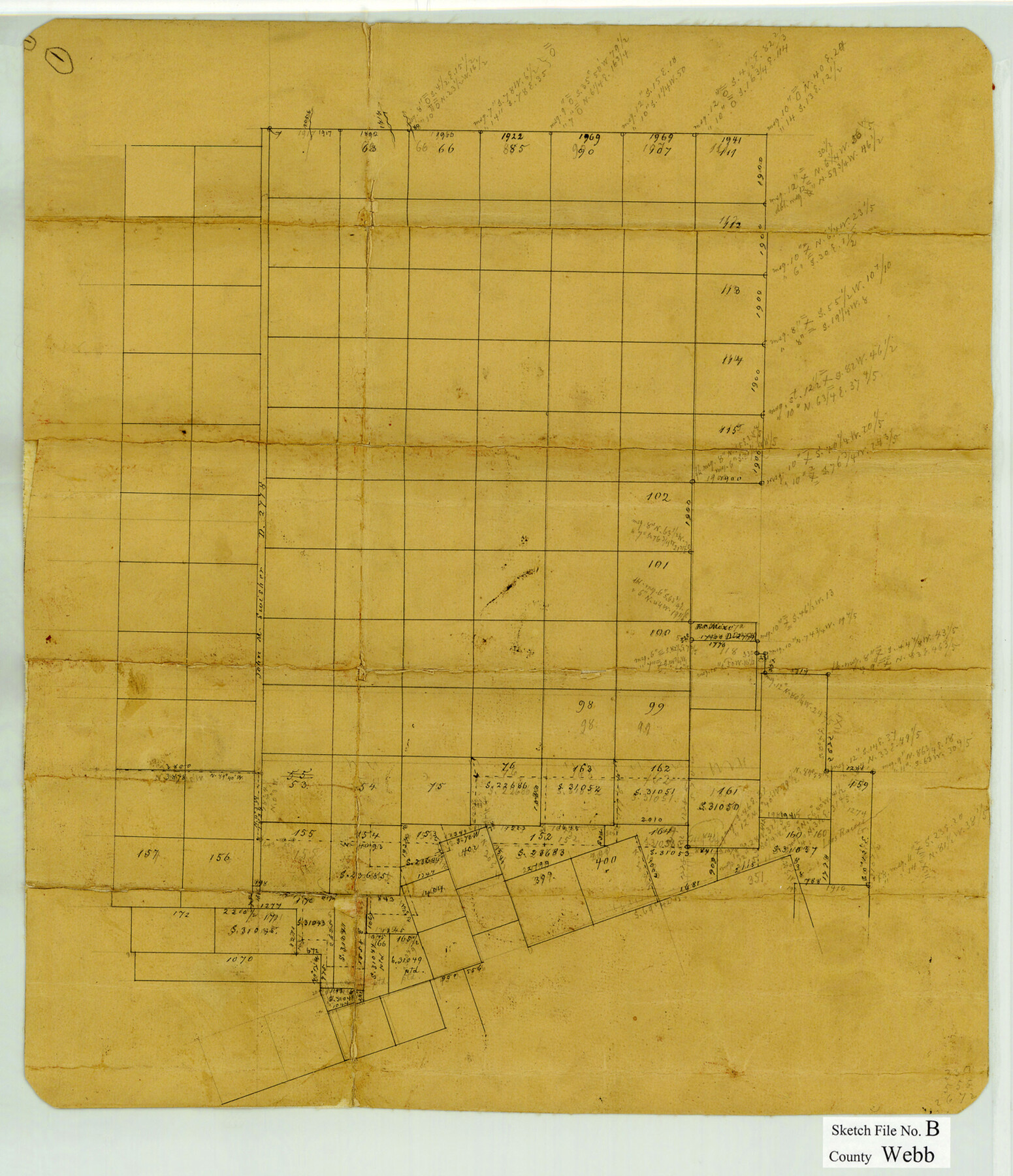
Webb County Sketch File B
[Sketch of surveys in the northeast corner of the county and extending into Dimmit and La Salle Counties]
-
Map/Doc
12605
-
Collection
General Map Collection
-
Object Dates
4/16/1892 (File Date)
-
People and Organizations
A. Eardley (Surveyor/Engineer)
-
Counties
Webb Dimmit La Salle
-
Subjects
Surveying Sketch File
-
Height x Width
15.9 x 13.7 inches
40.4 x 34.8 cm
-
Medium
paper, manuscript
Part of: General Map Collection
Howard County Rolled Sketch 12

Print $20.00
- Digital $50.00
Howard County Rolled Sketch 12
Size 25.8 x 16.5 inches
Map/Doc 6243
Flight Mission No. BQY-14M, Frame 184, Harris County

Print $20.00
- Digital $50.00
Flight Mission No. BQY-14M, Frame 184, Harris County
1953
Size 18.6 x 22.4 inches
Map/Doc 85300
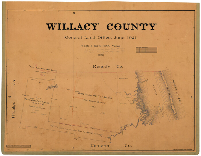
Willacy County
Print $20.00
- Digital $50.00
Willacy County
1921
Size 25.3 x 32.5 inches
Map/Doc 95675
Gonzales County

Print $20.00
- Digital $50.00
Gonzales County
1880
Size 26.3 x 24.0 inches
Map/Doc 4550
Lampasas County Sketch File 4

Print $4.00
- Digital $50.00
Lampasas County Sketch File 4
1861
Size 12.3 x 8.2 inches
Map/Doc 29394
Fannin County Sketch File 10

Print $20.00
- Digital $50.00
Fannin County Sketch File 10
Size 21.0 x 16.0 inches
Map/Doc 11471
Palo Pinto County Rolled Sketch 7

Print $20.00
- Digital $50.00
Palo Pinto County Rolled Sketch 7
Size 27.3 x 34.2 inches
Map/Doc 7190
Wharton County Rolled Sketch 11

Print $20.00
- Digital $50.00
Wharton County Rolled Sketch 11
Size 27.7 x 37.1 inches
Map/Doc 8236
Hale County Sketch File 14

Print $8.00
- Digital $50.00
Hale County Sketch File 14
Size 14.1 x 8.7 inches
Map/Doc 24743
Nueces County Rolled Sketch 68A

Print $165.00
- Digital $50.00
Nueces County Rolled Sketch 68A
1980
Size 9.8 x 15.0 inches
Map/Doc 47898
Stonewall County Sketch File 4

Print $20.00
- Digital $50.00
Stonewall County Sketch File 4
Size 18.2 x 25.7 inches
Map/Doc 12363
Wilbarger County Rolled Sketch 8

Print $20.00
- Digital $50.00
Wilbarger County Rolled Sketch 8
1965
Size 22.0 x 18.9 inches
Map/Doc 8257
You may also like
Flight Mission No. BRE-1P, Frame 97, Nueces County

Print $20.00
- Digital $50.00
Flight Mission No. BRE-1P, Frame 97, Nueces County
1956
Size 18.3 x 22.0 inches
Map/Doc 86668
Zavala County Working Sketch 4

Print $20.00
- Digital $50.00
Zavala County Working Sketch 4
1936
Size 21.1 x 23.4 inches
Map/Doc 62079
Newton County Working Sketch 34

Print $20.00
- Digital $50.00
Newton County Working Sketch 34
1959
Size 27.0 x 32.6 inches
Map/Doc 71280
Limestone County Working Sketch 8

Print $20.00
- Digital $50.00
Limestone County Working Sketch 8
1922
Size 30.6 x 18.4 inches
Map/Doc 70558
Township No. 2 South Range No. 21 West of the Indian Meridian

Print $20.00
- Digital $50.00
Township No. 2 South Range No. 21 West of the Indian Meridian
1875
Size 19.3 x 24.4 inches
Map/Doc 75177
Flight Mission No. BRA-16M, Frame 122, Jefferson County

Print $20.00
- Digital $50.00
Flight Mission No. BRA-16M, Frame 122, Jefferson County
1953
Size 18.5 x 22.5 inches
Map/Doc 85732
Pecos County Boundary File 2

Print $38.00
- Digital $50.00
Pecos County Boundary File 2
Size 11.2 x 8.7 inches
Map/Doc 57871
Sutton County Sketch File 56

Print $8.00
Sutton County Sketch File 56
1953
Size 11.2 x 9.0 inches
Map/Doc 37538
Brewster County Sketch File N-17

Print $80.00
- Digital $50.00
Brewster County Sketch File N-17
1939
Size 8.9 x 14.4 inches
Map/Doc 15651
[Sketch for Mineral Application 33721 - 33725 Incl. - Padre and Mustang Island]
![2879, [Sketch for Mineral Application 33721 - 33725 Incl. - Padre and Mustang Island], General Map Collection](https://historictexasmaps.com/wmedia_w700/maps/2879.tif.jpg)
Print $20.00
- Digital $50.00
[Sketch for Mineral Application 33721 - 33725 Incl. - Padre and Mustang Island]
1942
Size 29.4 x 22.2 inches
Map/Doc 2879
Flight Mission No. DAG-28K, Frame 26, Matagorda County

Print $20.00
- Digital $50.00
Flight Mission No. DAG-28K, Frame 26, Matagorda County
1953
Size 18.5 x 22.3 inches
Map/Doc 86594
Uvalde County Sketch File 8

Print $6.00
- Digital $50.00
Uvalde County Sketch File 8
1882
Size 8.4 x 6.2 inches
Map/Doc 38964