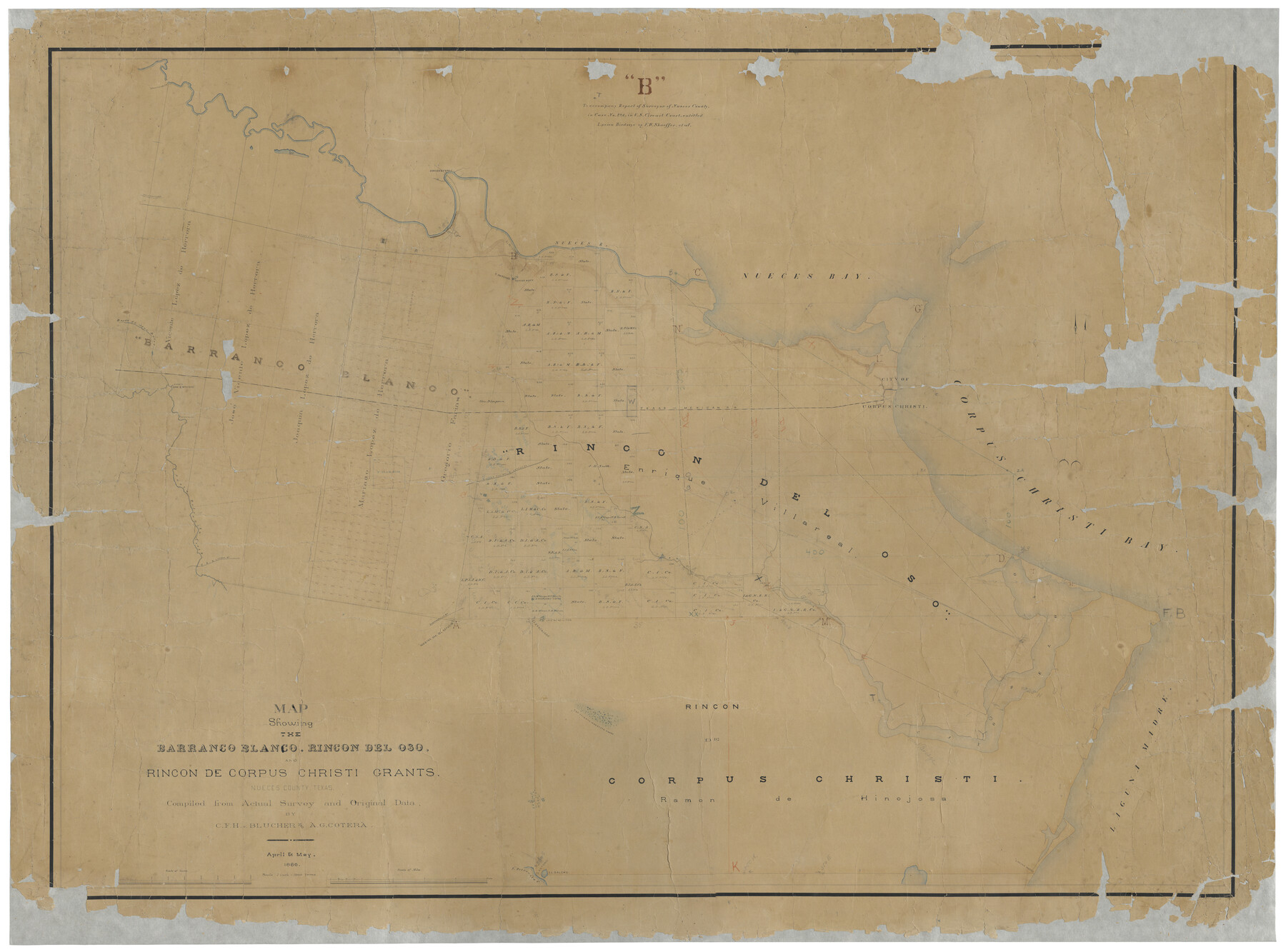
Map Showing the Barranco Blanco, Rincon del Oso, and Rincon de Corpus Christi Grants
-
Map/Doc
16781
-
Collection
General Map Collection
-
Object Dates
5/1886 (Creation Date)
-
People and Organizations
C.F.H. von Blucher (Compiler)
A.G. Cotera (Compiler)
-
Subjects
County
-
Height x Width
58.8 x 80.1 inches
149.4 x 203.5 cm
-
Comments
Compiled from actual survey and original data.
Conservation funded in 2002 in memory of William W. Green with donations from Gary Jeffress, Horatio Oliveira, James M. Goldston, Jamie Pyle, Murray Bass Jr., Coastal Bend Chapter 12 of the Texas Society o
Part of: General Map Collection
Red River County Sketch File 15

Print $4.00
- Digital $50.00
Red River County Sketch File 15
1863
Size 12.1 x 7.2 inches
Map/Doc 35137
Travis County Sketch File 1

Print $4.00
- Digital $50.00
Travis County Sketch File 1
Size 16.1 x 12.7 inches
Map/Doc 38270
Harris County Historic Topographic 6

Print $20.00
- Digital $50.00
Harris County Historic Topographic 6
1916
Size 29.9 x 22.8 inches
Map/Doc 65816
Flight Mission No. DQN-6K, Frame 15, Calhoun County

Print $20.00
- Digital $50.00
Flight Mission No. DQN-6K, Frame 15, Calhoun County
1953
Size 18.4 x 22.2 inches
Map/Doc 84437
Newton County

Print $40.00
- Digital $50.00
Newton County
1946
Size 48.7 x 42.6 inches
Map/Doc 73250
Flight Mission No. BQR-9K, Frame 51, Brazoria County

Print $20.00
- Digital $50.00
Flight Mission No. BQR-9K, Frame 51, Brazoria County
1952
Size 18.9 x 22.4 inches
Map/Doc 84055
McCulloch County Working Sketch 14

Print $20.00
- Digital $50.00
McCulloch County Working Sketch 14
1990
Size 15.3 x 29.0 inches
Map/Doc 70689
Stonewall County Working Sketch 31

Print $20.00
- Digital $50.00
Stonewall County Working Sketch 31
1983
Size 42.6 x 42.9 inches
Map/Doc 62338
El Paso County Rolled Sketch JE

Print $20.00
- Digital $50.00
El Paso County Rolled Sketch JE
1911
Size 27.4 x 45.5 inches
Map/Doc 8860
Matagorda County Sketch File 5

Print $4.00
- Digital $50.00
Matagorda County Sketch File 5
Size 10.0 x 8.0 inches
Map/Doc 30736
Flight Mission No. CGI-3N, Frame 96, Cameron County

Print $20.00
- Digital $50.00
Flight Mission No. CGI-3N, Frame 96, Cameron County
1954
Size 18.5 x 22.1 inches
Map/Doc 84576
Jasper County Sketch File 17

Print $20.00
- Digital $50.00
Jasper County Sketch File 17
1886
Size 27.5 x 35.4 inches
Map/Doc 10505
You may also like

Pecos County Working Sketch Graphic Index - northeast part - sheet B

Print $20.00
- Digital $50.00
Pecos County Working Sketch Graphic Index - northeast part - sheet B
1975
Size 36.0 x 42.2 inches
Map/Doc 76667
Hutchinson County Sketch File 5a

Print $6.00
- Digital $50.00
Hutchinson County Sketch File 5a
1900
Size 9.7 x 6.4 inches
Map/Doc 27195
Scurry County

Print $20.00
- Digital $50.00
Scurry County
1921
Size 41.4 x 38.1 inches
Map/Doc 73286
Runnels County Working Sketch 16

Print $20.00
- Digital $50.00
Runnels County Working Sketch 16
1950
Size 30.1 x 35.5 inches
Map/Doc 63612
Presidio County Rolled Sketch 53

Print $20.00
- Digital $50.00
Presidio County Rolled Sketch 53
1911
Size 23.9 x 18.2 inches
Map/Doc 7347
Map of Kyle, Lockhart & Southern Ry.

Print $40.00
- Digital $50.00
Map of Kyle, Lockhart & Southern Ry.
1882
Size 14.5 x 94.9 inches
Map/Doc 64285
Upshur County Boundary File 1

Print $30.00
- Digital $50.00
Upshur County Boundary File 1
Size 9.4 x 8.6 inches
Map/Doc 59500
Flight Mission No. DIX-8P, Frame 58, Aransas County

Print $20.00
- Digital $50.00
Flight Mission No. DIX-8P, Frame 58, Aransas County
1956
Size 18.6 x 22.5 inches
Map/Doc 83889
[Galveston, Harrisburg & San Antonio Railroad from Cuero to Stockdale]
![64197, [Galveston, Harrisburg & San Antonio Railroad from Cuero to Stockdale], General Map Collection](https://historictexasmaps.com/wmedia_w700/maps/64197.tif.jpg)
Print $20.00
- Digital $50.00
[Galveston, Harrisburg & San Antonio Railroad from Cuero to Stockdale]
1907
Size 13.9 x 34.1 inches
Map/Doc 64197
Calhoun County Sketch File 13

Print $36.00
- Digital $50.00
Calhoun County Sketch File 13
1940
Size 14.3 x 8.3 inches
Map/Doc 35962
Falls County Boundary File 1a

Print $56.00
- Digital $50.00
Falls County Boundary File 1a
1888
Size 14.6 x 9.2 inches
Map/Doc 53253