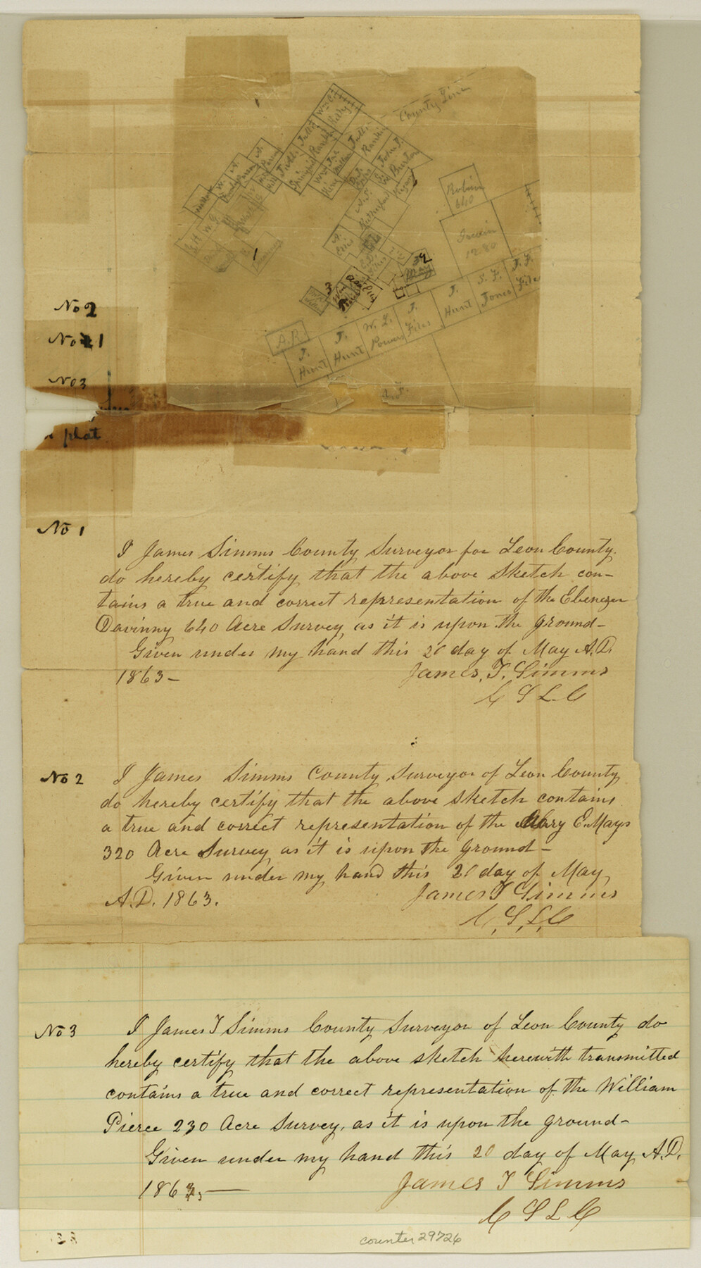
Leon County Sketch File 9
[Sketch north of Centerville]
-
Map/Doc
29726
-
Collection
General Map Collection
-
Object Dates
5/20/1863 (Creation Date)
6/23/1863 (File Date)
-
People and Organizations
J.T. Simms (Surveyor/Engineer)
-
Counties
Leon Freestone
-
Subjects
Surveying Sketch File
-
Height x Width
15.1 x 8.3 inches
38.4 x 21.1 cm
-
Medium
paper, manuscript
Part of: General Map Collection
Crockett County Sketch File A

Print $40.00
- Digital $50.00
Crockett County Sketch File A
Size 21.9 x 7.5 inches
Map/Doc 19624
Hall County Working Sketch 10

Print $20.00
- Digital $50.00
Hall County Working Sketch 10
1983
Size 34.3 x 42.9 inches
Map/Doc 63338
[Sketch for Mineral Application 21493 - Clay County]
![65625, [Sketch for Mineral Application 21493 - Clay County], General Map Collection](https://historictexasmaps.com/wmedia_w700/maps/65625-1.tif.jpg)
Print $40.00
- Digital $50.00
[Sketch for Mineral Application 21493 - Clay County]
Size 62.4 x 34.8 inches
Map/Doc 65625
Harris County Historic Topographic 22

Print $20.00
- Digital $50.00
Harris County Historic Topographic 22
1915
Size 29.2 x 22.7 inches
Map/Doc 65833
Nueces County Sketch File 12b

Print $8.00
- Digital $50.00
Nueces County Sketch File 12b
1889
Size 14.2 x 8.8 inches
Map/Doc 32530
Robertson County Working Sketch 7

Print $20.00
- Digital $50.00
Robertson County Working Sketch 7
1983
Size 36.6 x 38.3 inches
Map/Doc 78228
South Sulphur River, Klondike Sheet

Print $6.00
- Digital $50.00
South Sulphur River, Klondike Sheet
1925
Size 32.2 x 35.5 inches
Map/Doc 65170
Terry County Sketch File 6

Print $8.00
- Digital $50.00
Terry County Sketch File 6
1924
Size 11.2 x 8.7 inches
Map/Doc 38026
Jasper County Working Sketch 12

Print $40.00
- Digital $50.00
Jasper County Working Sketch 12
1920
Size 50.6 x 38.3 inches
Map/Doc 66474
Pecos County Working Sketch 70

Print $20.00
- Digital $50.00
Pecos County Working Sketch 70
1957
Size 31.4 x 27.0 inches
Map/Doc 71542
Flight Mission No. BRA-8M, Frame 135, Jefferson County

Print $20.00
- Digital $50.00
Flight Mission No. BRA-8M, Frame 135, Jefferson County
1953
Size 18.7 x 22.3 inches
Map/Doc 85631
Brewster County Rolled Sketch 22D

Print $20.00
- Digital $50.00
Brewster County Rolled Sketch 22D
1910
Size 32.3 x 24.9 inches
Map/Doc 5205
You may also like

The Republic County of Austin. February 5, 1840

Print $20.00
The Republic County of Austin. February 5, 1840
2020
Size 14.7 x 21.7 inches
Map/Doc 96084
[Surveys Along Canadian River]
![92359, [Surveys Along Canadian River], Twichell Survey Records](https://historictexasmaps.com/wmedia_w700/maps/92359-1.tif.jpg)
Print $20.00
- Digital $50.00
[Surveys Along Canadian River]
Size 42.9 x 27.0 inches
Map/Doc 92359
Denton County Sketch File 33

Print $4.00
- Digital $50.00
Denton County Sketch File 33
Size 8.2 x 12.4 inches
Map/Doc 20760
Colorado County Working Sketch 12

Print $20.00
- Digital $50.00
Colorado County Working Sketch 12
1943
Size 27.5 x 21.4 inches
Map/Doc 68112
Flight Mission No. BRA-16M, Frame 169, Jefferson County

Print $20.00
- Digital $50.00
Flight Mission No. BRA-16M, Frame 169, Jefferson County
1953
Size 18.7 x 22.6 inches
Map/Doc 85767
Brazoria County NRC Article 33.136 Sketch 17

Print $88.00
- Digital $50.00
Brazoria County NRC Article 33.136 Sketch 17
2015
Size 22.0 x 34.0 inches
Map/Doc 95020
Matagorda County NRC Article 33.136 Sketch 8

Print $30.00
- Digital $50.00
Matagorda County NRC Article 33.136 Sketch 8
2011
Size 24.0 x 36.0 inches
Map/Doc 94621
Nueces County Rolled Sketch 34

Print $20.00
- Digital $50.00
Nueces County Rolled Sketch 34
1951
Size 47.9 x 37.5 inches
Map/Doc 9601
Winkler Co., Tex., standard single county oil development survey

Print $20.00
- Digital $50.00
Winkler Co., Tex., standard single county oil development survey
Size 14.5 x 16.4 inches
Map/Doc 91972
Maps of Gulf Intracoastal Waterway, Texas - Sabine River to the Rio Grande and connecting waterways including ship channels

Print $20.00
- Digital $50.00
Maps of Gulf Intracoastal Waterway, Texas - Sabine River to the Rio Grande and connecting waterways including ship channels
1966
Size 14.2 x 20.7 inches
Map/Doc 61997
Jeff Davis County Sketch File R

Print $12.00
- Digital $50.00
Jeff Davis County Sketch File R
Size 6.0 x 8.7 inches
Map/Doc 28017