Mason County Sketch File 24
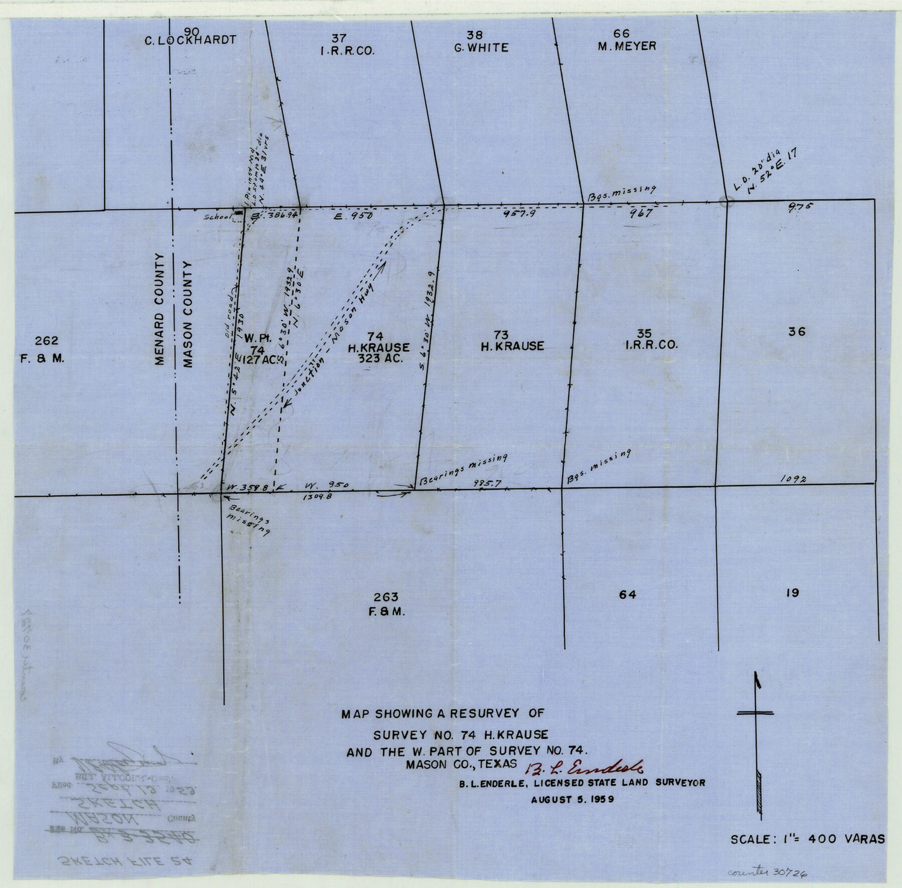
Map showing a resurvey of survey no. 74, H. Krause and the west part of survey no. 74
-
Map/Doc
30726
-
Collection
General Map Collection
-
Object Dates
8/5/1959 (Creation Date)
9/19/1959 (File Date)
-
People and Organizations
B.L. Enderle (Surveyor/Engineer)
-
Counties
Mason Menard
-
Subjects
Surveying Sketch File
-
Height x Width
15.0 x 15.2 inches
38.1 x 38.6 cm
-
Medium
paper, manuscript
-
Scale
1" = 400 varas
Part of: General Map Collection
Angelina County Sketch File 18c

Print $4.00
- Digital $50.00
Angelina County Sketch File 18c
Size 12.8 x 8.3 inches
Map/Doc 13034
Flight Mission No. BQR-9K, Frame 9, Brazoria County

Print $20.00
- Digital $50.00
Flight Mission No. BQR-9K, Frame 9, Brazoria County
1952
Size 18.6 x 22.3 inches
Map/Doc 84038
[Missouri, Kansas & Texas Line Map through Bastrop County]
![64029, [Missouri, Kansas & Texas Line Map through Bastrop County], General Map Collection](https://historictexasmaps.com/wmedia_w700/maps/64029.tif.jpg)
Print $40.00
- Digital $50.00
[Missouri, Kansas & Texas Line Map through Bastrop County]
1916
Size 25.8 x 122.6 inches
Map/Doc 64029
Pecos County Sketch File 47

Print $8.00
- Digital $50.00
Pecos County Sketch File 47
1935
Size 11.4 x 8.5 inches
Map/Doc 33759
Morris County Rolled Sketch 2A

Print $20.00
- Digital $50.00
Morris County Rolled Sketch 2A
Size 24.2 x 19.0 inches
Map/Doc 10276
Caldwell County Sketch File 4b

Print $8.00
- Digital $50.00
Caldwell County Sketch File 4b
1896
Size 6.4 x 3.8 inches
Map/Doc 35839
Sterling County Rolled Sketch 5

Print $20.00
- Digital $50.00
Sterling County Rolled Sketch 5
Size 42.1 x 28.7 inches
Map/Doc 7843
Somervell County Rolled Sketch C

Print $3.00
- Digital $50.00
Somervell County Rolled Sketch C
Size 9.0 x 13.4 inches
Map/Doc 7793
Milam County Boundary File 6c

Print $2.00
- Digital $50.00
Milam County Boundary File 6c
Size 11.2 x 8.5 inches
Map/Doc 57250
Cherokee County Sketch File 7

Print $4.00
- Digital $50.00
Cherokee County Sketch File 7
Size 10.3 x 8.3 inches
Map/Doc 18128
Kinney County Working Sketch 25

Print $20.00
- Digital $50.00
Kinney County Working Sketch 25
1952
Size 30.9 x 32.9 inches
Map/Doc 70207
Brazoria County Sketch File 10

Print $40.00
- Digital $50.00
Brazoria County Sketch File 10
Size 16.4 x 12.7 inches
Map/Doc 14938
You may also like
Harris County NRC Article 33.136 Sketch 7

Print $20.00
- Digital $50.00
Harris County NRC Article 33.136 Sketch 7
2004
Size 24.3 x 18.5 inches
Map/Doc 82991
[Mary Fury and B. H. Epperson surveys]
![93066, [Mary Fury and B. H. Epperson surveys], Twichell Survey Records](https://historictexasmaps.com/wmedia_w700/maps/93066-1.tif.jpg)
Print $3.00
- Digital $50.00
[Mary Fury and B. H. Epperson surveys]
1919
Size 10.6 x 14.6 inches
Map/Doc 93066
Amistad International Reservoir on Rio Grande 64

Print $20.00
- Digital $50.00
Amistad International Reservoir on Rio Grande 64
1949
Size 28.4 x 39.6 inches
Map/Doc 73349
Archer County Sketch File 21

Print $40.00
- Digital $50.00
Archer County Sketch File 21
Size 30.3 x 19.8 inches
Map/Doc 10830
Stonewall County Rolled Sketch 18

Print $20.00
- Digital $50.00
Stonewall County Rolled Sketch 18
1950
Size 27.4 x 29.4 inches
Map/Doc 7872
Matagorda Light to Aransas Pass

Print $20.00
- Digital $50.00
Matagorda Light to Aransas Pass
1934
Size 35.3 x 44.3 inches
Map/Doc 73392
General Highway Map. Detail of Cities and Towns in Orange County, Texas [Orange and vicinity]
![79622, General Highway Map. Detail of Cities and Towns in Orange County, Texas [Orange and vicinity], Texas State Library and Archives](https://historictexasmaps.com/wmedia_w700/maps/79622.tif.jpg)
Print $20.00
General Highway Map. Detail of Cities and Towns in Orange County, Texas [Orange and vicinity]
1961
Size 18.1 x 24.4 inches
Map/Doc 79622
[Sketch Showing Blocks O18, P Mc, B10 and B11]
![93107, [Sketch Showing Blocks O18, P Mc, B10 and B11], Twichell Survey Records](https://historictexasmaps.com/wmedia_w700/maps/93107-1.tif.jpg)
Print $3.00
- Digital $50.00
[Sketch Showing Blocks O18, P Mc, B10 and B11]
Size 11.5 x 11.2 inches
Map/Doc 93107
Webb County Working Sketch 63

Print $20.00
- Digital $50.00
Webb County Working Sketch 63
1962
Size 11.1 x 24.2 inches
Map/Doc 72429
Coryell County Sketch File 20

Print $20.00
- Digital $50.00
Coryell County Sketch File 20
Size 25.8 x 20.1 inches
Map/Doc 11183
Gaines County Rolled Sketch 12

Print $20.00
- Digital $50.00
Gaines County Rolled Sketch 12
1940
Size 26.6 x 33.8 inches
Map/Doc 5932
Briscoe County Sketch File 6

Print $40.00
- Digital $50.00
Briscoe County Sketch File 6
Size 29.8 x 24.6 inches
Map/Doc 10995