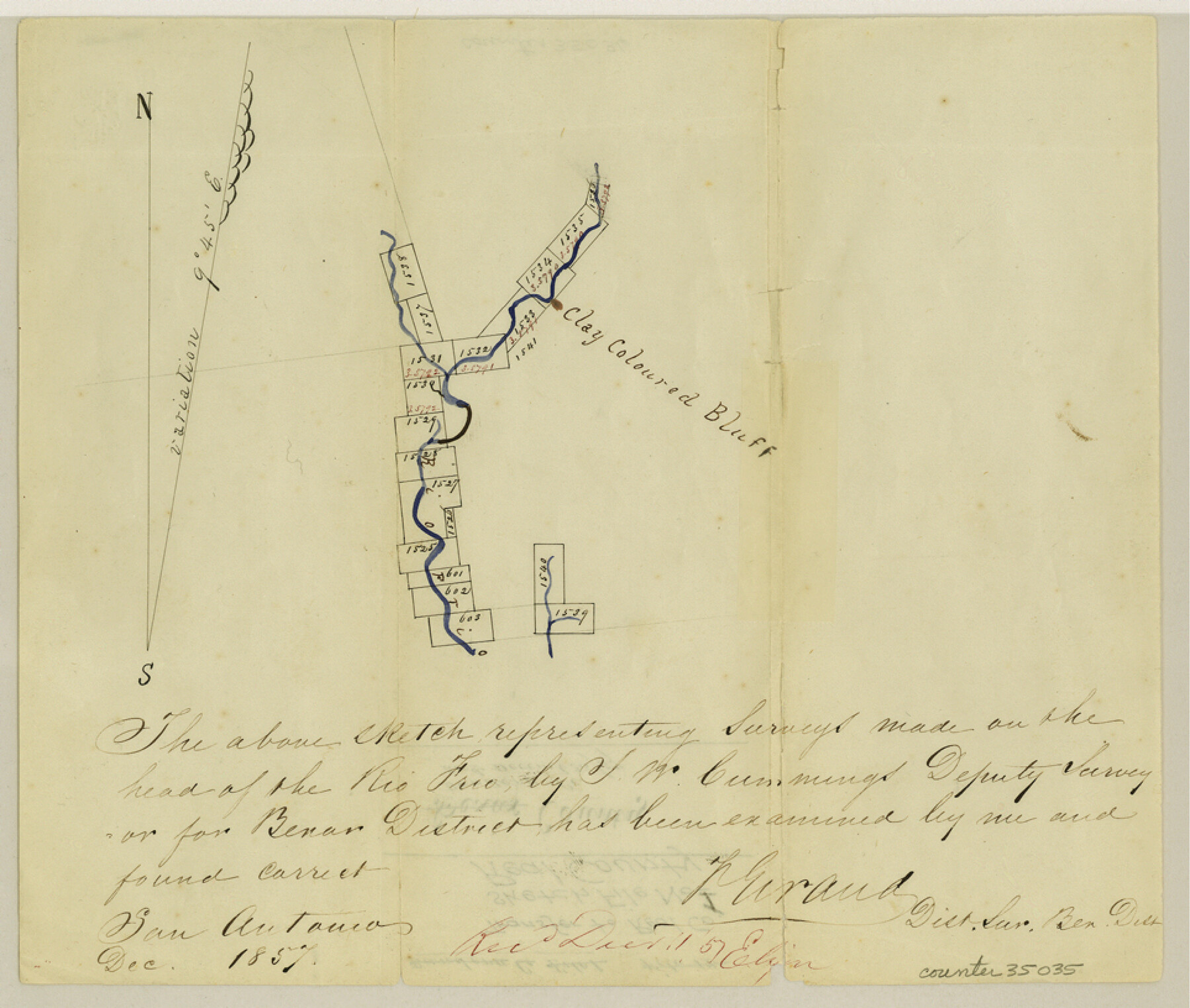
Real County Sketch File 1
[Sketch of surveys along the Frio River near the fork with the East Frio River]
-
Map/Doc
35035
-
Collection
General Map Collection
-
Object Dates
1857 (Creation Date)
1857/12/23 (File Date)
1857 (Survey Date)
-
People and Organizations
F. Giraud (Surveyor/Engineer)
J.W. Cummings (Surveyor/Engineer)
-
Counties
Real
-
Subjects
Surveying Sketch File
-
Height x Width
8.2 x 9.6 inches
20.8 x 24.4 cm
-
Medium
paper, manuscript
-
Features
Rio Frio
Part of: General Map Collection
Flight Mission No. DIX-10P, Frame 182, Aransas County

Print $20.00
- Digital $50.00
Flight Mission No. DIX-10P, Frame 182, Aransas County
1956
Size 18.6 x 22.3 inches
Map/Doc 83972
Potter County Working Sketch 9

Print $40.00
- Digital $50.00
Potter County Working Sketch 9
1966
Size 46.4 x 48.6 inches
Map/Doc 71669
[Missouri, Kansas & Texas] E. L. & R. R. Railroad, Morris Co.
![64273, [Missouri, Kansas & Texas] E. L. & R. R. Railroad, Morris Co., General Map Collection](https://historictexasmaps.com/wmedia_w700/maps/64273.tif.jpg)
Print $20.00
- Digital $50.00
[Missouri, Kansas & Texas] E. L. & R. R. Railroad, Morris Co.
1906
Size 13.1 x 28.4 inches
Map/Doc 64273
Sabine Pass and Lake

Print $20.00
- Digital $50.00
Sabine Pass and Lake
1973
Size 47.0 x 27.8 inches
Map/Doc 69826
Kimble County Sketch File 39

Print $12.00
- Digital $50.00
Kimble County Sketch File 39
1885
Size 14.1 x 8.6 inches
Map/Doc 28997
Flight Mission No. DQN-5K, Frame 23, Calhoun County

Print $20.00
- Digital $50.00
Flight Mission No. DQN-5K, Frame 23, Calhoun County
1953
Size 18.5 x 22.1 inches
Map/Doc 84374
Flight Mission No. DQN-5K, Frame 31, Calhoun County

Print $20.00
- Digital $50.00
Flight Mission No. DQN-5K, Frame 31, Calhoun County
1953
Size 18.5 x 22.1 inches
Map/Doc 84382
Nolan County Sketch File B

Print $20.00
- Digital $50.00
Nolan County Sketch File B
1902
Size 12.0 x 21.5 inches
Map/Doc 42171
St. Louis, Brownsville & Mexico Railway Location Map from Mile 120 to Rio Grande

Print $40.00
- Digital $50.00
St. Louis, Brownsville & Mexico Railway Location Map from Mile 120 to Rio Grande
1905
Size 19.6 x 67.7 inches
Map/Doc 64170
Edwards County Working Sketch 121

Print $20.00
- Digital $50.00
Edwards County Working Sketch 121
1976
Size 28.2 x 24.8 inches
Map/Doc 68997
University Land, Block 48, Culberson County, Texas

Print $20.00
- Digital $50.00
University Land, Block 48, Culberson County, Texas
1938
Size 28.1 x 21.7 inches
Map/Doc 2411
Presidio County Sketch File 87

Print $6.00
- Digital $50.00
Presidio County Sketch File 87
1951
Size 14.5 x 8.7 inches
Map/Doc 34748
You may also like
Dickens County Sketch File F1

Print $28.00
- Digital $50.00
Dickens County Sketch File F1
Size 11.4 x 8.7 inches
Map/Doc 20849
Flight Mission No. CUG-3P, Frame 37, Kleberg County

Print $20.00
- Digital $50.00
Flight Mission No. CUG-3P, Frame 37, Kleberg County
1956
Size 18.5 x 22.2 inches
Map/Doc 86242
Flight Mission No. DAG-17K, Frame 77, Matagorda County

Print $20.00
- Digital $50.00
Flight Mission No. DAG-17K, Frame 77, Matagorda County
1952
Size 16.7 x 16.3 inches
Map/Doc 86336
Hudspeth County Working Sketch 41

Print $20.00
- Digital $50.00
Hudspeth County Working Sketch 41
1981
Size 18.3 x 37.1 inches
Map/Doc 66326
[Sketch for Mineral Application 16700 - Pecos River Bed]
![2810, [Sketch for Mineral Application 16700 - Pecos River Bed], General Map Collection](https://historictexasmaps.com/wmedia_w700/maps/2810.tif.jpg)
Print $20.00
- Digital $50.00
[Sketch for Mineral Application 16700 - Pecos River Bed]
1927
Size 17.0 x 36.1 inches
Map/Doc 2810
The Republic County of Brazoria. December 29, 1845

Print $20.00
The Republic County of Brazoria. December 29, 1845
2020
Size 14.7 x 21.8 inches
Map/Doc 96115
Austin County Rolled Sketch 5B

Print $40.00
- Digital $50.00
Austin County Rolled Sketch 5B
Size 23.7 x 51.5 inches
Map/Doc 5107
Wichita County Sketch File 26

Print $20.00
- Digital $50.00
Wichita County Sketch File 26
1919
Size 24.9 x 36.6 inches
Map/Doc 12686

Portion of States Submerged Area in Matagorda Bay

Print $20.00
- Digital $50.00
Portion of States Submerged Area in Matagorda Bay
1923
Size 12.7 x 13.5 inches
Map/Doc 2956
Flight Mission No. DQO-3K, Frame 87, Galveston County

Print $20.00
- Digital $50.00
Flight Mission No. DQO-3K, Frame 87, Galveston County
1952
Size 18.7 x 22.4 inches
Map/Doc 85092
Randall County Rolled Sketch 7

Print $20.00
- Digital $50.00
Randall County Rolled Sketch 7
1949
Size 18.9 x 22.1 inches
Map/Doc 7427