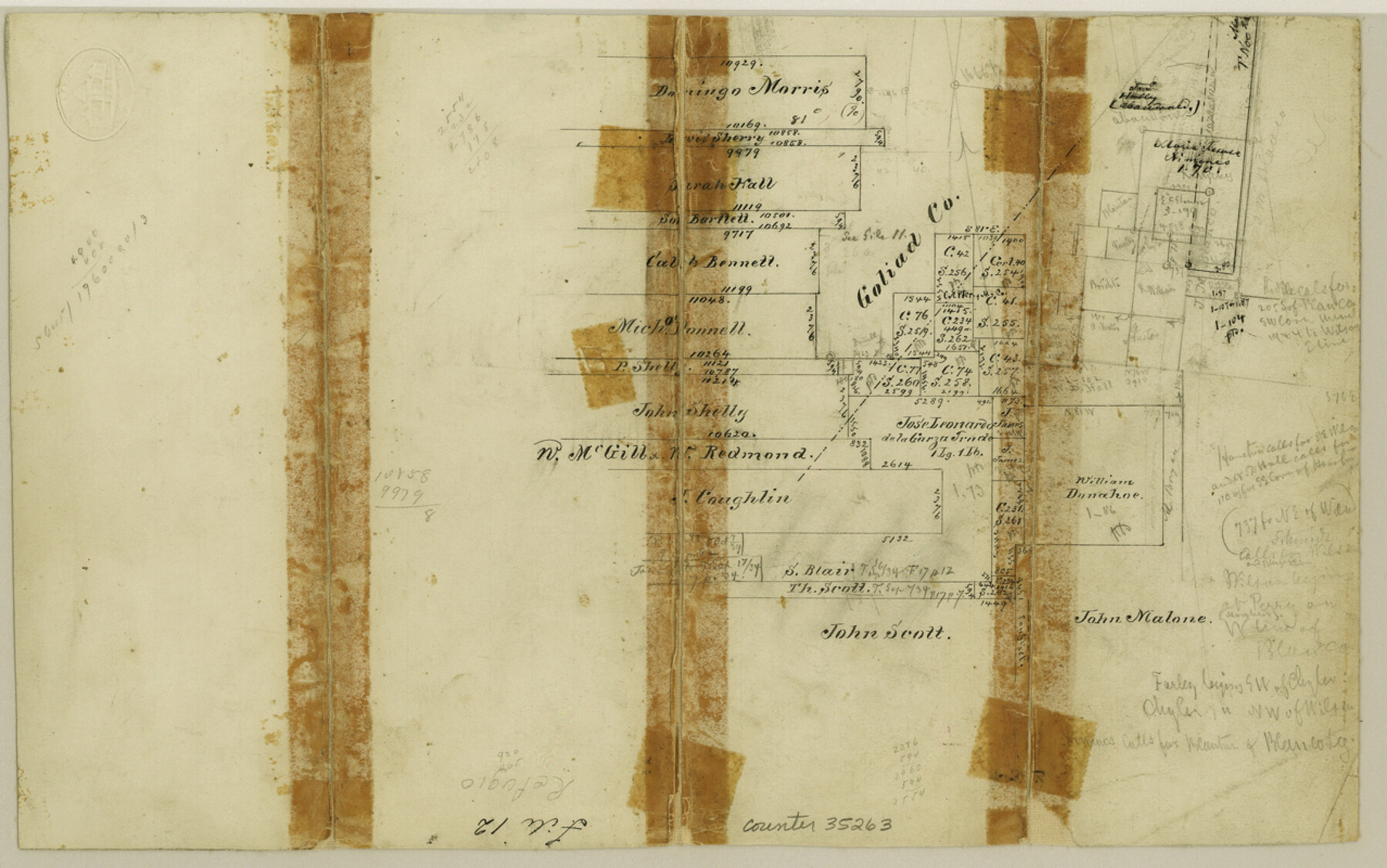
Refugio County Sketch File 12
[Sketch of surveys north of Refugio along Goliad County line]
-
Map/Doc
35263
-
Collection
General Map Collection
-
Counties
Refugio Goliad
-
Subjects
Surveying Sketch File
-
Height x Width
8.0 x 12.8 inches
20.3 x 32.5 cm
-
Medium
paper, manuscript
Part of: General Map Collection
Borden County Working Sketch 9

Print $20.00
- Digital $50.00
Borden County Working Sketch 9
1951
Size 24.8 x 42.3 inches
Map/Doc 67469
Donley County Boundary File 7

Print $31.00
- Digital $50.00
Donley County Boundary File 7
Size 11.3 x 8.6 inches
Map/Doc 52640
Map of Jefferson County Texas

Print $20.00
- Digital $50.00
Map of Jefferson County Texas
1879
Size 23.3 x 20.6 inches
Map/Doc 3729
Goliad County Working Sketch 17

Print $20.00
- Digital $50.00
Goliad County Working Sketch 17
1949
Size 21.8 x 22.2 inches
Map/Doc 63207
Colorado River Project - Texas, Marshall Ford Dam right of way survey

Print $20.00
- Digital $50.00
Colorado River Project - Texas, Marshall Ford Dam right of way survey
1937
Size 22.1 x 42.0 inches
Map/Doc 3151
Haskell County

Print $20.00
- Digital $50.00
Haskell County
1879
Size 21.0 x 20.4 inches
Map/Doc 1127
Flight Mission No. DQO-2K, Frame 89, Galveston County

Print $20.00
- Digital $50.00
Flight Mission No. DQO-2K, Frame 89, Galveston County
1952
Size 18.6 x 22.3 inches
Map/Doc 85016
Jack County Sketch File 4

Print $4.00
- Digital $50.00
Jack County Sketch File 4
1857
Size 9.0 x 12.7 inches
Map/Doc 27506
Camp County Working Sketch 4

Print $20.00
- Digital $50.00
Camp County Working Sketch 4
2003
Size 31.6 x 25.3 inches
Map/Doc 82432
Liberty County Working Sketch 74

Print $20.00
- Digital $50.00
Liberty County Working Sketch 74
1979
Size 38.8 x 35.4 inches
Map/Doc 70534
Maps of Gulf Intracoastal Waterway, Texas - Sabine River to the Rio Grande and connecting waterways including ship channels

Print $20.00
- Digital $50.00
Maps of Gulf Intracoastal Waterway, Texas - Sabine River to the Rio Grande and connecting waterways including ship channels
1966
Size 14.5 x 22.2 inches
Map/Doc 61931
Schleicher County Rolled Sketch 14

Print $20.00
- Digital $50.00
Schleicher County Rolled Sketch 14
1952
Size 37.3 x 34.0 inches
Map/Doc 9905
You may also like
Colorado County Sketch File 34

Print $86.00
- Digital $50.00
Colorado County Sketch File 34
1996
Size 14.2 x 8.8 inches
Map/Doc 18992
PSL Field Notes for Blocks A27 and A28 in Andrews and Gaines Counties, and Blocks A6 through A13, A20 through A26, and A30 in Gaines County

PSL Field Notes for Blocks A27 and A28 in Andrews and Gaines Counties, and Blocks A6 through A13, A20 through A26, and A30 in Gaines County
Map/Doc 81654

The Mexican Department of Brazos. Created, March 18, 1834

Print $20.00
The Mexican Department of Brazos. Created, March 18, 1834
2020
Size 19.7 x 21.7 inches
Map/Doc 95975
[Sketch for Mineral Application 16700 - Pecos River Bed]
![2807, [Sketch for Mineral Application 16700 - Pecos River Bed], General Map Collection](https://historictexasmaps.com/wmedia_w700/maps/2807.tif.jpg)
Print $20.00
- Digital $50.00
[Sketch for Mineral Application 16700 - Pecos River Bed]
1927
Size 32.9 x 15.3 inches
Map/Doc 2807
Johnson County Working Sketch 13

Print $20.00
- Digital $50.00
Johnson County Working Sketch 13
1969
Size 32.0 x 41.0 inches
Map/Doc 66626
Calhoun County Rolled Sketch 30

Print $20.00
- Digital $50.00
Calhoun County Rolled Sketch 30
1974
Size 18.6 x 27.2 inches
Map/Doc 5497
General Highway Map. Detail of Cities and Towns in Walker County, Texas [Huntsville and vicinity]
![79699, General Highway Map. Detail of Cities and Towns in Walker County, Texas [Huntsville and vicinity], Texas State Library and Archives](https://historictexasmaps.com/wmedia_w700/maps/79699.tif.jpg)
Print $20.00
General Highway Map. Detail of Cities and Towns in Walker County, Texas [Huntsville and vicinity]
1961
Size 18.1 x 24.8 inches
Map/Doc 79699
Flight Mission No. BQR-20K, Frame 8, Brazoria County

Print $20.00
- Digital $50.00
Flight Mission No. BQR-20K, Frame 8, Brazoria County
1952
Size 18.6 x 22.3 inches
Map/Doc 84110
Tarrant County Boundary File 2

Print $6.00
- Digital $50.00
Tarrant County Boundary File 2
Size 14.4 x 9.0 inches
Map/Doc 59111

Coast of Texas from head of East Bay Galveston Harbor to Sabine Pass

Print $40.00
- Digital $50.00
Coast of Texas from head of East Bay Galveston Harbor to Sabine Pass
1882
Size 32.6 x 54.1 inches
Map/Doc 69838