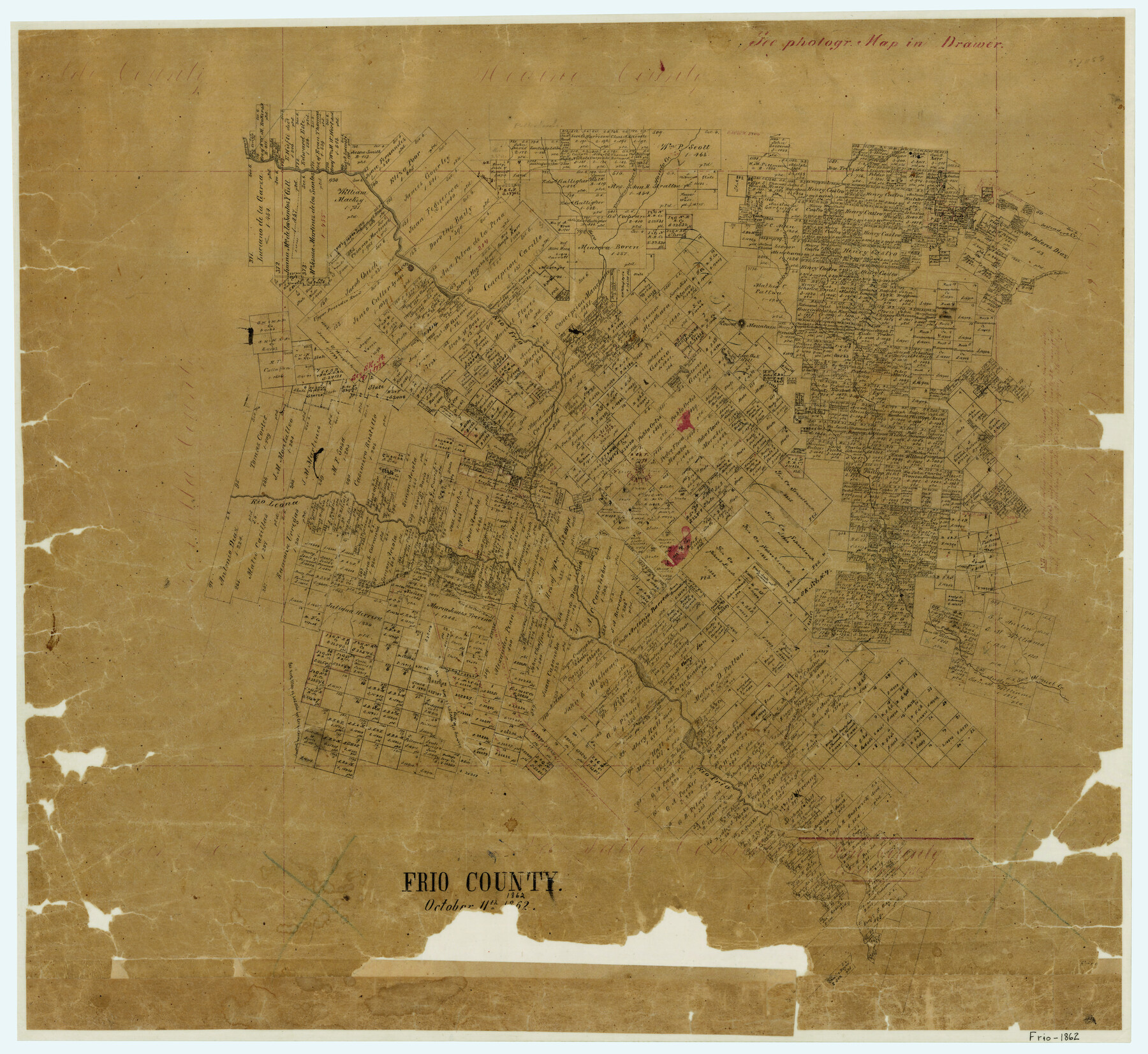
Frio County
-
Map/Doc
3569
-
Collection
General Map Collection
-
Object Dates
10/11/1862 (Creation Date)
-
Counties
Frio
-
Subjects
County
-
Height x Width
25.0 x 27.2 inches
63.5 x 69.1 cm
-
Features
Turkey Creek
Little Live Oak Creek
Huisache Lake
Cisquidera Creek
Chacon Creek
Rio Sabinal
Rio Leona
Clear Creek
Live Oak Hill
Round Mountain
Road to Fort Ewell
Cañada de Ruiz
Todos Santos Creek
Live Oak Creek
Frio City
San Miguel Creek
Escondido Creek
Elm Creek
Cañada de Padilla
Sesteadero Creek
Francisco Perez Creek
Black Creek
Gaspar Flores Creek
Rio Frio
Hondo Creek
Tawacano [sic] Creek
Seco Creek
Upper Presidio Road
Part of: General Map Collection
The Coast of Mexico from Laguna de Esmotes to Punta Brava

Print $20.00
- Digital $50.00
The Coast of Mexico from Laguna de Esmotes to Punta Brava
1775
Size 22.2 x 29.8 inches
Map/Doc 95920
Shelby County Sketch File 11

Print $50.00
- Digital $50.00
Shelby County Sketch File 11
1859
Size 8.8 x 7.0 inches
Map/Doc 36613
Hutchinson County Working Sketch 49

Print $20.00
- Digital $50.00
Hutchinson County Working Sketch 49
1988
Size 35.2 x 37.3 inches
Map/Doc 66409
Angelina County Working Sketch 2

Print $20.00
- Digital $50.00
Angelina County Working Sketch 2
1899
Size 18.3 x 23.4 inches
Map/Doc 67082
Shelby County Sketch File 6

Print $8.00
- Digital $50.00
Shelby County Sketch File 6
1854
Size 12.4 x 8.2 inches
Map/Doc 36601
Erath County Sketch File 10

Print $4.00
- Digital $50.00
Erath County Sketch File 10
1871
Size 8.1 x 10.3 inches
Map/Doc 22275
Flight Mission No. DCL-6C, Frame 20, Kenedy County

Print $20.00
- Digital $50.00
Flight Mission No. DCL-6C, Frame 20, Kenedy County
1943
Size 18.7 x 22.4 inches
Map/Doc 85877
Tom Green County Sketch File 37a

Print $24.00
- Digital $50.00
Tom Green County Sketch File 37a
1881
Size 18.5 x 24.0 inches
Map/Doc 12437
Travis County Rolled Sketch 43

Print $20.00
- Digital $50.00
Travis County Rolled Sketch 43
1962
Size 27.3 x 22.7 inches
Map/Doc 8041
Flight Mission No. BRA-16M, Frame 59, Jefferson County

Print $20.00
- Digital $50.00
Flight Mission No. BRA-16M, Frame 59, Jefferson County
1953
Size 18.3 x 22.5 inches
Map/Doc 85676
Corpus Christi Bay

Print $20.00
- Digital $50.00
Corpus Christi Bay
1971
Size 36.4 x 47.4 inches
Map/Doc 73472
Aransas County Sketch File 20

Print $4.00
- Digital $50.00
Aransas County Sketch File 20
1896
Size 8.2 x 10.2 inches
Map/Doc 13155
You may also like
Map of Portion of Matagorda Bay in Matagorda County showing subdivision thereof for mineral development

Print $20.00
- Digital $50.00
Map of Portion of Matagorda Bay in Matagorda County showing subdivision thereof for mineral development
1937
Size 38.3 x 36.6 inches
Map/Doc 2921
Cottle County Sketch File 4

Print $16.00
- Digital $50.00
Cottle County Sketch File 4
Size 8.2 x 4.2 inches
Map/Doc 19466
Edwards County Working Sketch 27

Print $20.00
- Digital $50.00
Edwards County Working Sketch 27
1944
Size 27.7 x 23.9 inches
Map/Doc 68903
Cass County Sketch File 2

Print $4.00
- Digital $50.00
Cass County Sketch File 2
1849
Size 12.4 x 7.7 inches
Map/Doc 17394
Texas, Matagorda Bay, Liveoak Bay

Print $40.00
- Digital $50.00
Texas, Matagorda Bay, Liveoak Bay
1933
Size 32.5 x 48.9 inches
Map/Doc 69992
Gregg County Rolled Sketch JB2

Print $20.00
- Digital $50.00
Gregg County Rolled Sketch JB2
1933
Size 42.0 x 35.1 inches
Map/Doc 8341
Lavaca County Sketch File 6

Print $2.00
- Digital $50.00
Lavaca County Sketch File 6
Size 7.3 x 3.2 inches
Map/Doc 29641
Chambers County Sketch File 10b

Print $4.00
- Digital $50.00
Chambers County Sketch File 10b
1841
Size 9.6 x 8.2 inches
Map/Doc 17552
Milam County Boundary File 6c

Print $2.00
- Digital $50.00
Milam County Boundary File 6c
Size 11.2 x 8.5 inches
Map/Doc 57250
Franklin County Boundary File 2

Print $60.00
- Digital $50.00
Franklin County Boundary File 2
Size 26.1 x 13.2 inches
Map/Doc 53573
Culberson County Sketch File 32

Print $22.00
- Digital $50.00
Culberson County Sketch File 32
1952
Size 11.2 x 8.7 inches
Map/Doc 20285
Part of Tom Green County, Texas (No. 2)

Print $20.00
- Digital $50.00
Part of Tom Green County, Texas (No. 2)
1870
Size 22.9 x 18.0 inches
Map/Doc 5046