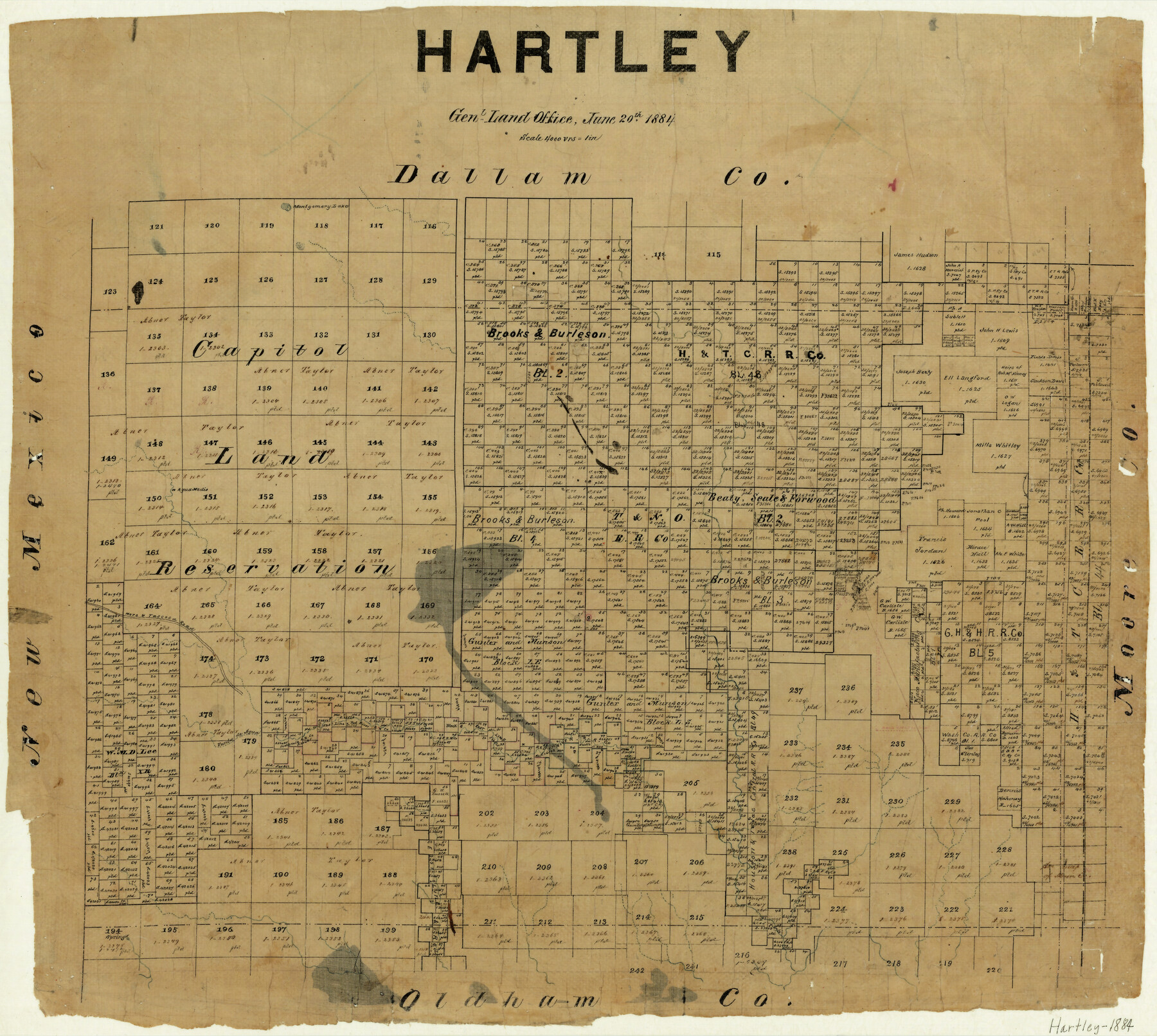
Hartley
-
Map/Doc
3637
-
Collection
General Map Collection
-
Object Dates
6/20/1884 (Creation Date)
-
Counties
Hartley
-
Subjects
County
-
Height x Width
24.0 x 26.8 inches
61.0 x 68.1 cm
-
Features
Montgomery Lake
Agua Medio River
Moto and Tascosa Road
Punta de Agua River
Punta de Agua Creek
Agua Medio Creek
EL&RR
IRR
Mustang Creek
Canadian River
Part of: General Map Collection
Mason County Sketch File 19

Print $20.00
- Digital $50.00
Mason County Sketch File 19
1901
Size 19.1 x 20.9 inches
Map/Doc 12036
Loving County Rolled Sketch 15

Print $20.00
- Digital $50.00
Loving County Rolled Sketch 15
2015
Size 36.2 x 24.4 inches
Map/Doc 93793
Motley County Sketch File F (S)

Print $14.00
- Digital $50.00
Motley County Sketch File F (S)
1904
Size 9.1 x 5.9 inches
Map/Doc 32179
Schleicher County Sketch File 48

Print $4.00
- Digital $50.00
Schleicher County Sketch File 48
1953
Size 11.2 x 8.7 inches
Map/Doc 36558
Map representing the surveys made in Bexar County

Print $40.00
- Digital $50.00
Map representing the surveys made in Bexar County
1839
Size 75.7 x 35.1 inches
Map/Doc 93365
Railroad Track Map, H&TCRRCo., Falls County, Texas

Print $4.00
- Digital $50.00
Railroad Track Map, H&TCRRCo., Falls County, Texas
1918
Size 11.7 x 18.5 inches
Map/Doc 62858
Brown County Sketch File 10a

Print $6.00
- Digital $50.00
Brown County Sketch File 10a
Size 11.2 x 9.8 inches
Map/Doc 16595
Map of Franklin County

Print $20.00
- Digital $50.00
Map of Franklin County
1879
Size 21.1 x 10.4 inches
Map/Doc 3560
Madison County

Print $20.00
- Digital $50.00
Madison County
1871
Size 15.2 x 20.3 inches
Map/Doc 4587
Jim Wells County Sketch File 2

Print $6.00
- Digital $50.00
Jim Wells County Sketch File 2
1931
Size 11.1 x 8.7 inches
Map/Doc 28424
Map of Tyler County

Print $20.00
- Digital $50.00
Map of Tyler County
1897
Size 42.0 x 37.5 inches
Map/Doc 16907

You may also like
Crockett County Sketch File 72

Print $14.00
- Digital $50.00
Crockett County Sketch File 72
Size 14.0 x 8.6 inches
Map/Doc 19862
Val Verde County Sketch File 52a

Print $20.00
- Digital $50.00
Val Verde County Sketch File 52a
1885
Size 21.5 x 22.1 inches
Map/Doc 12592
Liberty County Working Sketch 19

Print $20.00
- Digital $50.00
Liberty County Working Sketch 19
1940
Size 29.2 x 41.3 inches
Map/Doc 70478
Hood County Working Sketch 30

Print $20.00
- Digital $50.00
Hood County Working Sketch 30
1990
Size 26.6 x 29.9 inches
Map/Doc 66224
Tyler County Sketch File 11

Print $4.00
- Digital $50.00
Tyler County Sketch File 11
1849
Size 11.3 x 5.6 inches
Map/Doc 38650
Angelina County Sketch File 28

Print $22.00
- Digital $50.00
Angelina County Sketch File 28
1910
Size 15.7 x 12.0 inches
Map/Doc 13078
Presidio County Working Sketch 110

Print $20.00
- Digital $50.00
Presidio County Working Sketch 110
1981
Size 38.7 x 32.2 inches
Map/Doc 71787
Pecos County Working Sketch 104

Print $40.00
- Digital $50.00
Pecos County Working Sketch 104
1971
Size 63.1 x 26.9 inches
Map/Doc 71577
Burnet County Rolled Sketch D

Print $20.00
- Digital $50.00
Burnet County Rolled Sketch D
1924
Size 47.3 x 40.8 inches
Map/Doc 8541
Dimmit County Sketch File 19 1/2a

Print $12.00
- Digital $50.00
Dimmit County Sketch File 19 1/2a
1887
Size 14.2 x 8.8 inches
Map/Doc 21094
Brewster County Sketch File N-16

Print $16.00
- Digital $50.00
Brewster County Sketch File N-16
1922
Size 6.2 x 8.7 inches
Map/Doc 15643
Yoakum County Sketch File 20

Print $22.00
- Digital $50.00
Yoakum County Sketch File 20
1977
Size 13.1 x 14.5 inches
Map/Doc 40841