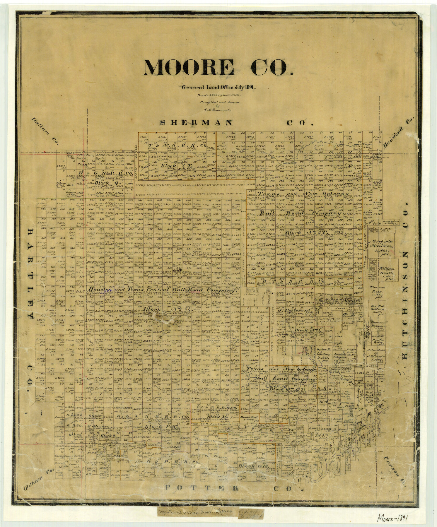
Moore County
-
Map/Doc
3902
-
Collection
General Map Collection
-
Object Dates
1891 (Creation Date)
-
People and Organizations
Texas General Land Office (Publisher)
G.N. Beaumont (Draftsman)
G.N. Beaumont (Compiler)
-
Counties
Moore
-
Subjects
County
-
Height x Width
25.5 x 21.1 inches
64.8 x 53.6 cm
-
Features
Palo Duro Creek
Little Blue Creek
Pollard Creek
Big Blue Creek
Grapevine Creek
Canadian River
Dumas
Part of: General Map Collection

Anderson County Working Sketch 6

Print $20.00
- Digital $50.00
Anderson County Working Sketch 6
1913
Size 24.7 x 26.3 inches
Map/Doc 67005
Dickens County Rolled Sketch 10

Print $20.00
- Digital $50.00
Dickens County Rolled Sketch 10
Size 43.0 x 31.9 inches
Map/Doc 8789
Roberts County Rolled Sketch 5

Print $20.00
- Digital $50.00
Roberts County Rolled Sketch 5
2015
Size 42.6 x 25.0 inches
Map/Doc 94071
Pecos County Sketch File 38

Print $4.00
- Digital $50.00
Pecos County Sketch File 38
1895
Size 11.3 x 8.8 inches
Map/Doc 33720
Henderson County Working Sketch 43

Print $20.00
- Digital $50.00
Henderson County Working Sketch 43
1994
Size 36.7 x 39.0 inches
Map/Doc 66176
San Patricio County Boundary File 77

Digital $50.00
San Patricio County Boundary File 77
Map/Doc 81963
Gonzales County Sketch File 10

Print $4.00
- Digital $50.00
Gonzales County Sketch File 10
1873
Size 8.4 x 5.2 inches
Map/Doc 24390
El Paso County Rolled Sketch W

Print $20.00
- Digital $50.00
El Paso County Rolled Sketch W
1916
Size 22.8 x 40.1 inches
Map/Doc 5859
Controlled Mosaic by Jack Amman Photogrammetric Engineers, Inc - Sheet 19

Print $20.00
- Digital $50.00
Controlled Mosaic by Jack Amman Photogrammetric Engineers, Inc - Sheet 19
1954
Size 20.0 x 24.0 inches
Map/Doc 83464
Hall County Sketch File 24

Print $10.00
- Digital $50.00
Hall County Sketch File 24
1911
Size 11.2 x 8.6 inches
Map/Doc 24817
[Gulf, Colorado & Santa Fe]
![64590, [Gulf, Colorado & Santa Fe], General Map Collection](https://historictexasmaps.com/wmedia_w700/maps/64590.tif.jpg)
Print $40.00
- Digital $50.00
[Gulf, Colorado & Santa Fe]
1918
Size 31.4 x 117.0 inches
Map/Doc 64590
You may also like
Mitchell County

Print $20.00
- Digital $50.00
Mitchell County
1889
Size 42.3 x 35.7 inches
Map/Doc 10792
Starr County Working Sketch 19

Print $20.00
- Digital $50.00
Starr County Working Sketch 19
1982
Size 27.3 x 33.9 inches
Map/Doc 63935
Washington County Sketch File 3

Print $4.00
- Digital $50.00
Washington County Sketch File 3
1860
Size 8.1 x 9.2 inches
Map/Doc 39648
Llano County Working Sketch Graphic Index

Print $20.00
- Digital $50.00
Llano County Working Sketch Graphic Index
1943
Size 43.7 x 42.6 inches
Map/Doc 76624
Archer County Working Sketch 15

Print $20.00
- Digital $50.00
Archer County Working Sketch 15
1948
Size 20.7 x 31.9 inches
Map/Doc 67156
Map of the Fort Worth and Denver City Railway, through Wilbarger County Texas, 1882

Print $40.00
- Digital $50.00
Map of the Fort Worth and Denver City Railway, through Wilbarger County Texas, 1882
Size 22.6 x 79.4 inches
Map/Doc 64427
Flight Mission No. BRE-1P, Frame 68, Nueces County

Print $20.00
- Digital $50.00
Flight Mission No. BRE-1P, Frame 68, Nueces County
1956
Size 17.7 x 21.8 inches
Map/Doc 86650
Galveston County Sketch File 73g

Print $20.00
- Digital $50.00
Galveston County Sketch File 73g
Size 32.1 x 41.2 inches
Map/Doc 10460
Corpus Christi Harbor

Print $40.00
- Digital $50.00
Corpus Christi Harbor
1975
Size 37.6 x 51.5 inches
Map/Doc 73479
[Sketch for Mineral Application 33721 - 33725 Incl. - Padre and Mustang Island]
![2868, [Sketch for Mineral Application 33721 - 33725 Incl. - Padre and Mustang Island], General Map Collection](https://historictexasmaps.com/wmedia_w700/maps/2868.tif.jpg)
Print $20.00
- Digital $50.00
[Sketch for Mineral Application 33721 - 33725 Incl. - Padre and Mustang Island]
1942
Size 29.7 x 22.3 inches
Map/Doc 2868
Northeastern United States Including the Great Lakes Region

Northeastern United States Including the Great Lakes Region
1959
Size 25.6 x 19.3 inches
Map/Doc 92395
Nueces County Rolled Sketch 118

Print $20.00
- Digital $50.00
Nueces County Rolled Sketch 118
1988
Size 19.5 x 35.4 inches
Map/Doc 7150