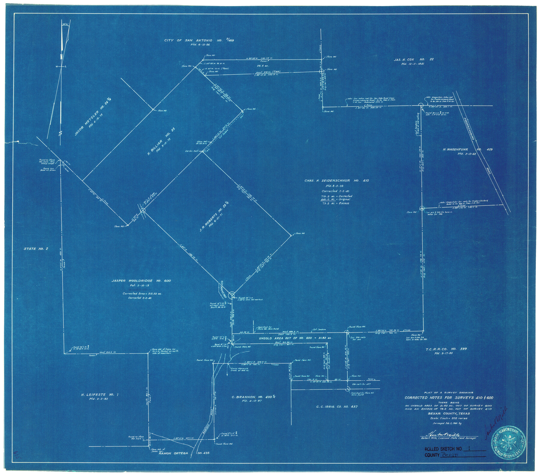
Bexar County Rolled Sketch 1
Plat of a survey showing corrected notes for surveys 410 & 600 there being an unsold area of 31.82 ac. out of survey 600 and an excess of 79.2 ac. out of survey 410
-
Map/Doc
5134
-
Collection
General Map Collection
-
Object Dates
2/2/1940 (Creation Date)
2/13/1940 (File Date)
-
People and Organizations
Herbert Mills (Surveyor/Engineer)
-
Counties
Bexar
-
Subjects
Surveying Rolled Sketch
-
Height x Width
23.1 x 26.2 inches
58.7 x 66.6 cm
-
Medium
blueprint/diazo
-
Scale
1" = 200 varas
-
Comments
See Bexar County Sketch File 53 (14539) for surveyor’s report.
Related maps
Bexar County Sketch File 53

Print $8.00
- Digital $50.00
Bexar County Sketch File 53
Size 11.4 x 8.9 inches
Map/Doc 14539
Part of: General Map Collection
Map of the Recognised Line, M. El. P. & P. RR. from Texas & Arkansas State Line to Milam & Bexar Land District Line

Print $40.00
- Digital $50.00
Map of the Recognised Line, M. El. P. & P. RR. from Texas & Arkansas State Line to Milam & Bexar Land District Line
Size 15.3 x 89.4 inches
Map/Doc 64638
Angelina County Rolled Sketch 1

Print $20.00
- Digital $50.00
Angelina County Rolled Sketch 1
Size 30.4 x 29.6 inches
Map/Doc 77184
Flight Mission No. BRA-16M, Frame 143, Jefferson County

Print $20.00
- Digital $50.00
Flight Mission No. BRA-16M, Frame 143, Jefferson County
1953
Size 18.5 x 22.2 inches
Map/Doc 85749
Flight Mission No. CRE-1R, Frame 123, Jackson County

Print $20.00
- Digital $50.00
Flight Mission No. CRE-1R, Frame 123, Jackson County
1956
Size 16.0 x 16.0 inches
Map/Doc 85334
Jeff Davis County Working Sketch 24

Print $40.00
- Digital $50.00
Jeff Davis County Working Sketch 24
1958
Size 24.9 x 52.9 inches
Map/Doc 66519
Upton County Sketch File 32

Print $20.00
- Digital $50.00
Upton County Sketch File 32
1938
Size 14.9 x 24.0 inches
Map/Doc 12523
[Surveys East of river copied from U.S. map of Township No. 6 South, Range No. 9 West of the Indian Meridian, Oklahoma]
![75185, [Surveys East of river copied from U.S. map of Township No. 6 South, Range No. 9 West of the Indian Meridian, Oklahoma], General Map Collection](https://historictexasmaps.com/wmedia_w700/maps/75185.tif.jpg)
Print $2.00
- Digital $50.00
[Surveys East of river copied from U.S. map of Township No. 6 South, Range No. 9 West of the Indian Meridian, Oklahoma]
Size 13.3 x 9.0 inches
Map/Doc 75185
Flight Mission No. CLL-1N, Frame 183, Willacy County

Print $20.00
- Digital $50.00
Flight Mission No. CLL-1N, Frame 183, Willacy County
1954
Size 18.3 x 22.0 inches
Map/Doc 87053
Wheeler County Sketch File 1

Print $20.00
- Digital $50.00
Wheeler County Sketch File 1
Size 17.1 x 26.8 inches
Map/Doc 12672
Right of Way Location Map, San Antonio & Aransas Pass, Station 656…

Print $4.00
- Digital $50.00
Right of Way Location Map, San Antonio & Aransas Pass, Station 656…
1919
Size 11.8 x 18.6 inches
Map/Doc 62567
Hutchinson County Rolled Sketch 40

Print $20.00
- Digital $50.00
Hutchinson County Rolled Sketch 40
1981
Size 26.1 x 37.5 inches
Map/Doc 6298
Map of Chocolate Bay, west portion of West Bay & vicinity, Brazoria & Galveston Counties showing subdivision for mineral development

Print $40.00
- Digital $50.00
Map of Chocolate Bay, west portion of West Bay & vicinity, Brazoria & Galveston Counties showing subdivision for mineral development
Size 42.0 x 58.1 inches
Map/Doc 65806
You may also like
Flight Mission No. BQR-22K, Frame 46, Brazoria County

Print $20.00
- Digital $50.00
Flight Mission No. BQR-22K, Frame 46, Brazoria County
1953
Size 18.6 x 22.4 inches
Map/Doc 84130
[St. L. S-W. Ry. of Texas Map of Lufkin Branch in Cherokee County Texas]
![64018, [St. L. S-W. Ry. of Texas Map of Lufkin Branch in Cherokee County Texas], General Map Collection](https://historictexasmaps.com/wmedia_w700/maps/64018.tif.jpg)
Print $40.00
- Digital $50.00
[St. L. S-W. Ry. of Texas Map of Lufkin Branch in Cherokee County Texas]
1912
Size 22.3 x 121.1 inches
Map/Doc 64018
Lampasas County Rolled Sketch 1

Print $20.00
- Digital $50.00
Lampasas County Rolled Sketch 1
1975
Size 22.0 x 28.2 inches
Map/Doc 6564
Flight Mission No. DQN-1K, Frame 50, Calhoun County

Print $20.00
- Digital $50.00
Flight Mission No. DQN-1K, Frame 50, Calhoun County
1953
Size 18.7 x 22.3 inches
Map/Doc 84150
The Kennedy and Pringle Colony. June 3, 1842

Print $20.00
The Kennedy and Pringle Colony. June 3, 1842
2020
Size 23.0 x 17.7 inches
Map/Doc 96368
Runnels County Sketch File 12

Print $20.00
Runnels County Sketch File 12
1883
Size 32.9 x 30.9 inches
Map/Doc 10592
Township No. 4 South Range No. 14 West of the Indian Meridian

Print $4.00
- Digital $50.00
Township No. 4 South Range No. 14 West of the Indian Meridian
1875
Size 18.0 x 22.4 inches
Map/Doc 75144
Edwards County Sketch File 37

Print $4.00
- Digital $50.00
Edwards County Sketch File 37
1926
Size 11.3 x 9.0 inches
Map/Doc 21771
McMullen County Rolled Sketch 9

Print $20.00
- Digital $50.00
McMullen County Rolled Sketch 9
Size 34.4 x 40.9 inches
Map/Doc 6726
Subdivisions of University League 8 in Cooke County

Subdivisions of University League 8 in Cooke County
Map/Doc 81728
San Jacinto County Sketch File 18

Print $20.00
San Jacinto County Sketch File 18
1934
Size 43.6 x 18.1 inches
Map/Doc 10599
Polk County Working Sketch 23a

Print $40.00
- Digital $50.00
Polk County Working Sketch 23a
1957
Size 32.9 x 54.1 inches
Map/Doc 71638