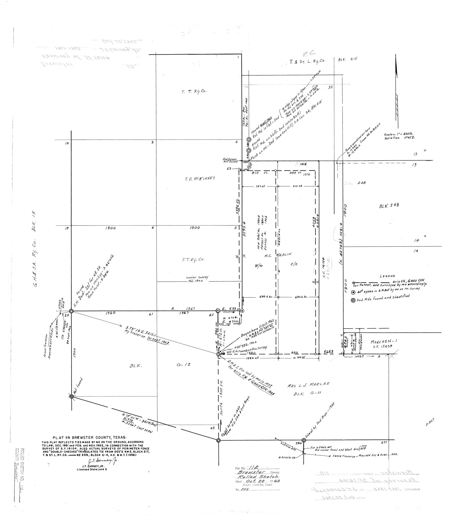
Brewster County Rolled Sketch 112
[Plat reflecting ties on the ground in connection with the survey of SF-16104]
-
Map/Doc
5263
-
Collection
General Map Collection
-
Object Dates
1962 (Creation Date)
1962/10/22 (File Date)
-
People and Organizations
J.T. Carney, Jr. (Surveyor/Engineer)
-
Counties
Brewster
-
Subjects
Surveying Rolled Sketch
-
Height x Width
28.9 x 25.7 inches
73.4 x 65.3 cm
-
Scale
1" = 400 varas
Part of: General Map Collection
Uvalde County Sketch File 25

Print $8.00
- Digital $50.00
Uvalde County Sketch File 25
1928
Size 14.5 x 8.8 inches
Map/Doc 39016
Mills County Boundary File 3a

Print $48.00
- Digital $50.00
Mills County Boundary File 3a
Size 14.2 x 8.8 inches
Map/Doc 57287
Flight Mission No. DQO-2K, Frame 149, Galveston County

Print $20.00
- Digital $50.00
Flight Mission No. DQO-2K, Frame 149, Galveston County
1952
Size 18.8 x 22.4 inches
Map/Doc 85046
Menard County Sketch File 5

Print $20.00
- Digital $50.00
Menard County Sketch File 5
Size 5.6 x 43.3 inches
Map/Doc 10542
Upshur County Sketch File 12

Print $8.00
- Digital $50.00
Upshur County Sketch File 12
Size 10.3 x 8.0 inches
Map/Doc 38751
Bandera County Sketch File 34

Print $6.00
- Digital $50.00
Bandera County Sketch File 34
1987
Size 14.1 x 8.7 inches
Map/Doc 14030
Wharton County Rolled Sketch 6

Print $20.00
- Digital $50.00
Wharton County Rolled Sketch 6
1901
Size 23.7 x 30.0 inches
Map/Doc 8230
Kleberg County Rolled Sketch 10-30

Print $20.00
- Digital $50.00
Kleberg County Rolled Sketch 10-30
1952
Size 35.3 x 38.0 inches
Map/Doc 9400
Haskell County Working Sketch 8

Print $20.00
- Digital $50.00
Haskell County Working Sketch 8
1957
Size 22.8 x 24.0 inches
Map/Doc 66066
Brewster County Sketch File N-17

Print $80.00
- Digital $50.00
Brewster County Sketch File N-17
1939
Size 8.9 x 14.4 inches
Map/Doc 15651
Concho County Rolled Sketch 10

Print $20.00
- Digital $50.00
Concho County Rolled Sketch 10
1957
Size 22.9 x 26.0 inches
Map/Doc 5548
Chambers County NRC Article 33.136 Location Key Sheet

Print $20.00
- Digital $50.00
Chambers County NRC Article 33.136 Location Key Sheet
1983
Size 24.0 x 44.0 inches
Map/Doc 77014
You may also like
Brewster County Sketch File 47

Print $12.00
- Digital $50.00
Brewster County Sketch File 47
1939
Size 14.1 x 8.8 inches
Map/Doc 16321
2008 Official Travel Map, Texas

2008 Official Travel Map, Texas
Size 33.4 x 36.5 inches
Map/Doc 94343
General Highway Map, Detail of Cities and Towns in Delta County, Hopkins County [Cooper and vicinity]
![79440, General Highway Map, Detail of Cities and Towns in Delta County, Hopkins County [Cooper and vicinity], Texas State Library and Archives](https://historictexasmaps.com/wmedia_w700/maps/79440.tif.jpg)
Print $20.00
General Highway Map, Detail of Cities and Towns in Delta County, Hopkins County [Cooper and vicinity]
1961
Size 18.2 x 24.4 inches
Map/Doc 79440
General Highway Map. Detail of Cities and Towns in Angelina County, Texas [Lufkin and vicinity]
![79351, General Highway Map. Detail of Cities and Towns in Angelina County, Texas [Lufkin and vicinity], Texas State Library and Archives](https://historictexasmaps.com/wmedia_w700/maps/79351.tif.jpg)
Print $20.00
General Highway Map. Detail of Cities and Towns in Angelina County, Texas [Lufkin and vicinity]
1961
Size 18.3 x 25.0 inches
Map/Doc 79351
Dimmit County Sketch File 45

Print $20.00
- Digital $50.00
Dimmit County Sketch File 45
1905
Size 24.9 x 25.5 inches
Map/Doc 11355
Johnson County

Print $20.00
- Digital $50.00
Johnson County
1857
Size 19.2 x 29.1 inches
Map/Doc 3734
Palo Pinto County Sketch File 21

Print $20.00
- Digital $50.00
Palo Pinto County Sketch File 21
1896
Size 18.5 x 17.5 inches
Map/Doc 12133
Map of Calhoun County, Texas

Print $20.00
- Digital $50.00
Map of Calhoun County, Texas
1879
Size 22.8 x 18.7 inches
Map/Doc 670
Culberson County Working Sketch 62

Print $20.00
- Digital $50.00
Culberson County Working Sketch 62
1975
Size 32.2 x 24.6 inches
Map/Doc 68516
The Texas and Oklahoma Official Railway and Hotel Guide Map

Print $20.00
The Texas and Oklahoma Official Railway and Hotel Guide Map
1906
Size 23.5 x 23.4 inches
Map/Doc 79316
[Bastrop County line]
![65, [Bastrop County line], General Map Collection](https://historictexasmaps.com/wmedia_w700/maps/65.tif.jpg)
Print $2.00
- Digital $50.00
[Bastrop County line]
1841
Size 7.8 x 6.3 inches
Map/Doc 65
San Patricio County Sketch File 51

Print $12.00
- Digital $50.00
San Patricio County Sketch File 51
1917
Size 11.2 x 8.8 inches
Map/Doc 36375