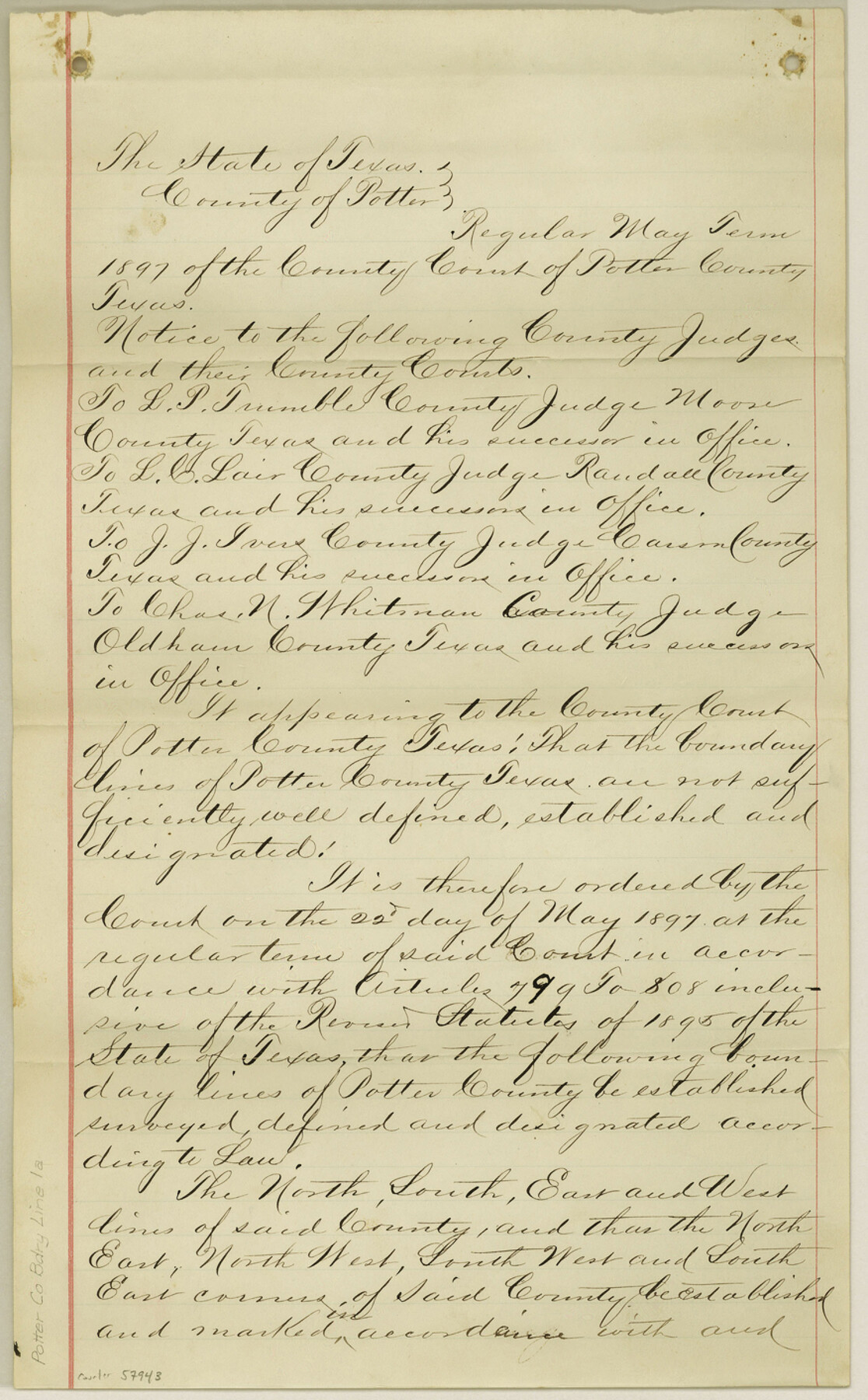
Potter County Boundary File 1a
Order of the County Court of Potter County
-
Map/Doc
57943
-
Collection
General Map Collection
-
Counties
Potter
-
Subjects
County Boundaries
-
Height x Width
14.1 x 8.8 inches
35.8 x 22.4 cm
Part of: General Map Collection
Real County Working Sketch 53

Print $20.00
- Digital $50.00
Real County Working Sketch 53
1959
Size 29.4 x 27.9 inches
Map/Doc 71945
Flight Mission No. DAG-23K, Frame 178, Matagorda County

Print $20.00
- Digital $50.00
Flight Mission No. DAG-23K, Frame 178, Matagorda County
1953
Size 18.8 x 22.5 inches
Map/Doc 86513
Delta County Working Sketch 3

Print $20.00
- Digital $50.00
Delta County Working Sketch 3
1963
Size 24.9 x 24.4 inches
Map/Doc 68640
1988 Land Use - El Paso, Ciudad Juarez and Vicinity

Print $20.00
- Digital $50.00
1988 Land Use - El Paso, Ciudad Juarez and Vicinity
1988
Size 34.1 x 25.0 inches
Map/Doc 87370
Hunt County Rolled Sketch 5

Print $20.00
- Digital $50.00
Hunt County Rolled Sketch 5
1966
Size 24.7 x 24.4 inches
Map/Doc 6273
Trinity County Working Sketch 7a

Print $20.00
- Digital $50.00
Trinity County Working Sketch 7a
1933
Size 39.7 x 27.3 inches
Map/Doc 69455
PSL Field Notes for Block A19 in Andrews County, C45 in Andrews and Gaines Counties, C31 in Dawson and Gaines Counties, C34 in Terry and Gaines Counties, C35 in Yoakum and Gaines Counties, and Blocks C30, C32, C33, C43, and C44 in Gaines County

PSL Field Notes for Block A19 in Andrews County, C45 in Andrews and Gaines Counties, C31 in Dawson and Gaines Counties, C34 in Terry and Gaines Counties, C35 in Yoakum and Gaines Counties, and Blocks C30, C32, C33, C43, and C44 in Gaines County
Map/Doc 81643
Dallas County Sketch File 18

Print $6.00
- Digital $50.00
Dallas County Sketch File 18
1871
Size 15.8 x 11.0 inches
Map/Doc 20437
Travis County Working Sketch 17

Print $20.00
- Digital $50.00
Travis County Working Sketch 17
1944
Size 27.8 x 23.3 inches
Map/Doc 69401
Right of Way and Track Map Texas & New Orleans R.R. Co. operated by the T. & N. O. R.R. Co. Dallas-Sabine Branch

Print $40.00
- Digital $50.00
Right of Way and Track Map Texas & New Orleans R.R. Co. operated by the T. & N. O. R.R. Co. Dallas-Sabine Branch
1918
Size 24.3 x 55.9 inches
Map/Doc 64156
Kenedy County Rolled Sketch 10

Print $20.00
- Digital $50.00
Kenedy County Rolled Sketch 10
1915
Size 21.7 x 35.7 inches
Map/Doc 6470
Jeff Davis County Rolled Sketch 9

Print $20.00
- Digital $50.00
Jeff Davis County Rolled Sketch 9
Size 18.3 x 22.9 inches
Map/Doc 6362
You may also like
Morris County Rolled Sketch 2A

Print $20.00
- Digital $50.00
Morris County Rolled Sketch 2A
Size 24.0 x 18.8 inches
Map/Doc 10275
Wharton County Working Sketch 9

Print $3.00
- Digital $50.00
Wharton County Working Sketch 9
1982
Size 12.4 x 10.4 inches
Map/Doc 72473
Wise County Sketch File 22

Print $4.00
- Digital $50.00
Wise County Sketch File 22
1860
Size 7.5 x 7.2 inches
Map/Doc 40566
General Highway Map, Potter County, Texas

Print $20.00
General Highway Map, Potter County, Texas
1940
Size 24.6 x 18.3 inches
Map/Doc 79220
J. De Cordova's Map of the State of Texas Compiled from the records of the General Land Office of the State

Print $20.00
J. De Cordova's Map of the State of Texas Compiled from the records of the General Land Office of the State
1849
Size 35.7 x 33.6 inches
Map/Doc 93964
[Sketch around I. G. Yates S.F. 12394]
![91548, [Sketch around I. G. Yates S.F. 12394], Twichell Survey Records](https://historictexasmaps.com/wmedia_w700/maps/91548-1.tif.jpg)
Print $3.00
- Digital $50.00
[Sketch around I. G. Yates S.F. 12394]
Size 17.3 x 7.2 inches
Map/Doc 91548
Sketch Showing Division Fence, Shelton- Matador, Oldham County

Print $20.00
- Digital $50.00
Sketch Showing Division Fence, Shelton- Matador, Oldham County
Size 20.4 x 18.6 inches
Map/Doc 91445

Flight Mission No. DQN-5K, Frame 32, Calhoun County

Print $20.00
- Digital $50.00
Flight Mission No. DQN-5K, Frame 32, Calhoun County
1953
Size 16.5 x 16.3 inches
Map/Doc 84383
[Edwards Co.]
![66811, [Edwards Co.], General Map Collection](https://historictexasmaps.com/wmedia_w700/maps/66811.tif.jpg)
Print $20.00
- Digital $50.00
[Edwards Co.]
1910
Size 38.8 x 36.2 inches
Map/Doc 66811
Edwards County Working Sketch 21

Print $20.00
- Digital $50.00
Edwards County Working Sketch 21
1935
Size 26.7 x 32.0 inches
Map/Doc 68897
Andrews County Sketch File 1

Print $6.00
- Digital $50.00
Andrews County Sketch File 1
Size 9.0 x 13.6 inches
Map/Doc 12818