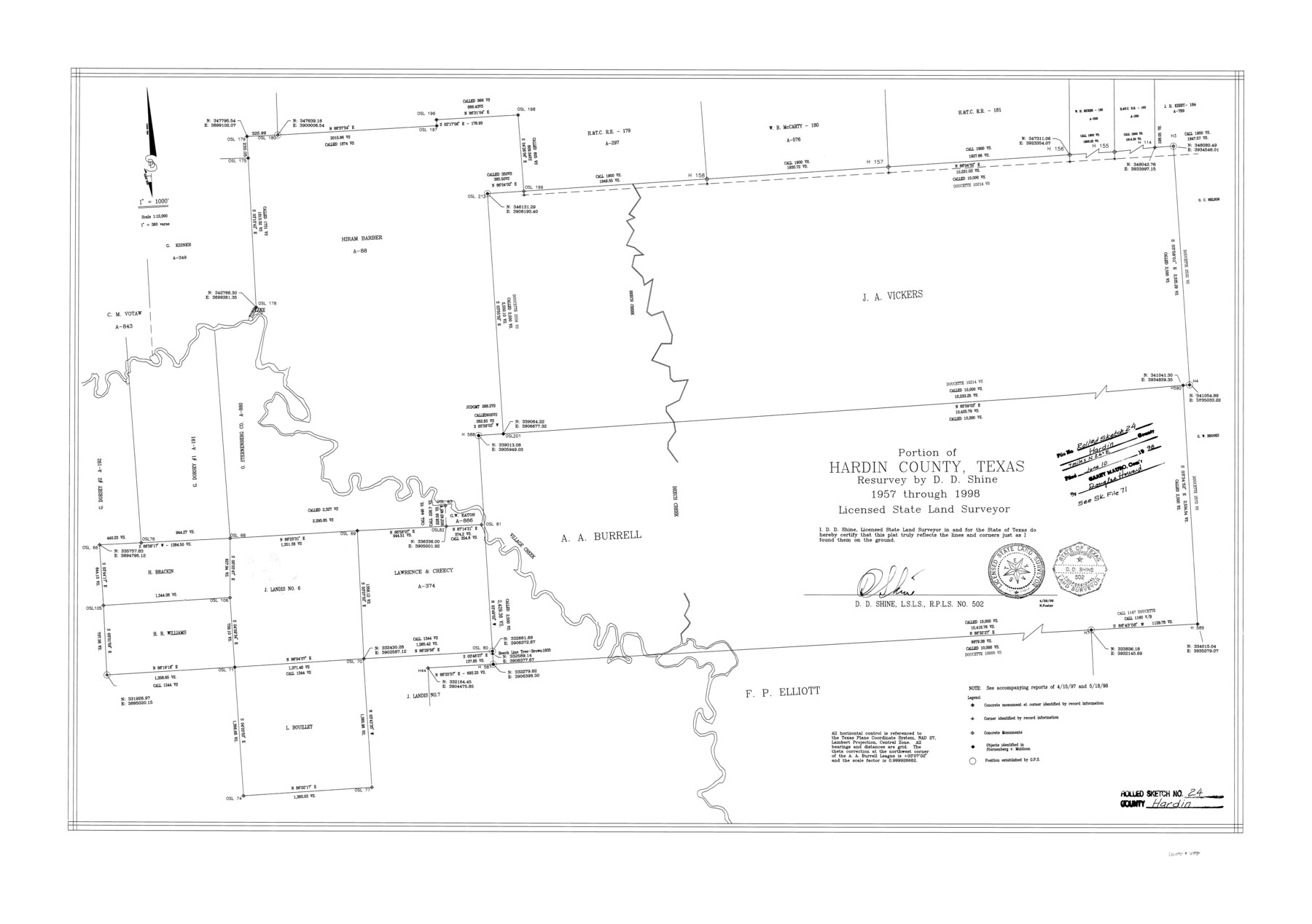
Hardin County Rolled Sketch 24
Portion of Hardin County, Texas
-
Map/Doc
6092
-
Collection
General Map Collection
-
Object Dates
1998 (Creation Date)
1998/6/10 (File Date)
-
People and Organizations
D.D. Shine (Surveyor/Engineer)
-
Counties
Hardin
-
Subjects
Surveying Rolled Sketch
-
Height x Width
27.2 x 38.6 inches
69.1 x 98.0 cm
-
Medium
mylar, print
-
Scale
1" = 360 varas
-
Comments
See Hardin County Sketch File 71 (25259), 71e (11642) and 71f (11643)
Related maps
Hardin County Sketch File 71e

Print $20.00
- Digital $50.00
Hardin County Sketch File 71e
Size 25.2 x 37.1 inches
Map/Doc 11642
Hardin County Sketch File 71f

Print $20.00
- Digital $50.00
Hardin County Sketch File 71f
1997
Size 25.2 x 36.7 inches
Map/Doc 11643
Hardin County Sketch File 71

Print $94.00
- Digital $50.00
Hardin County Sketch File 71
1997
Size 11.4 x 8.8 inches
Map/Doc 25259
Part of: General Map Collection
Brazos River, Brazos River Sheet 5

Print $4.00
- Digital $50.00
Brazos River, Brazos River Sheet 5
1926
Size 29.4 x 22.5 inches
Map/Doc 65298
Flight Mission No. BQY-4M, Frame 42, Harris County

Print $20.00
- Digital $50.00
Flight Mission No. BQY-4M, Frame 42, Harris County
1953
Size 18.7 x 22.4 inches
Map/Doc 85257
Subdivision Plat of Blue Ridge State Farm Showing 18 Tracts

Print $20.00
- Digital $50.00
Subdivision Plat of Blue Ridge State Farm Showing 18 Tracts
Size 27.0 x 27.4 inches
Map/Doc 62978
Flight Mission No. DQN-2K, Frame 46, Calhoun County

Print $20.00
- Digital $50.00
Flight Mission No. DQN-2K, Frame 46, Calhoun County
1953
Size 18.5 x 22.1 inches
Map/Doc 84251
Starr County Sketch File 31B

Print $14.00
- Digital $50.00
Starr County Sketch File 31B
1936
Size 14.2 x 8.8 inches
Map/Doc 36960
Mitchell County Boundary File 66c

Print $19.00
- Digital $50.00
Mitchell County Boundary File 66c
Size 12.7 x 8.3 inches
Map/Doc 57390
Galveston to Rio Grande

Print $20.00
- Digital $50.00
Galveston to Rio Grande
1967
Size 44.4 x 37.0 inches
Map/Doc 69955
Plan of the City of Austin

Print $40.00
- Digital $50.00
Plan of the City of Austin
1840
Size 57.3 x 42.0 inches
Map/Doc 2179
Bandera County Sketch File 26

Print $6.00
- Digital $50.00
Bandera County Sketch File 26
1879
Size 7.7 x 8.3 inches
Map/Doc 14016
Bexar County Sketch File 27

Print $4.00
- Digital $50.00
Bexar County Sketch File 27
1860
Size 8.6 x 6.5 inches
Map/Doc 14490
Flight Mission No. BRE-2P, Frame 130, Nueces County

Print $20.00
- Digital $50.00
Flight Mission No. BRE-2P, Frame 130, Nueces County
1956
Size 18.6 x 22.3 inches
Map/Doc 86803
Flight Mission No. CGI-1N, Frame 172, Cameron County

Print $20.00
- Digital $50.00
Flight Mission No. CGI-1N, Frame 172, Cameron County
1955
Size 18.5 x 22.2 inches
Map/Doc 84507
You may also like
Vereinigte Staaten von Nord America

Print $20.00
- Digital $50.00
Vereinigte Staaten von Nord America
1828
Size 17.6 x 21.9 inches
Map/Doc 93644
Maverick County Sketch File 7

Print $15.00
- Digital $50.00
Maverick County Sketch File 7
1878
Size 16.6 x 3.9 inches
Map/Doc 31057
Flight Mission No. CRC-4R, Frame 150, Chambers County

Print $20.00
- Digital $50.00
Flight Mission No. CRC-4R, Frame 150, Chambers County
1956
Size 18.6 x 22.4 inches
Map/Doc 84913
Phelps & Ensigns Travellers' Guide, and Map of the United States, containing the roads, distances, steam boat and canal routes & c.

Print $40.00
- Digital $50.00
Phelps & Ensigns Travellers' Guide, and Map of the United States, containing the roads, distances, steam boat and canal routes & c.
1844
Map/Doc 97114
Atascosa County Sketch File 28

Print $40.00
- Digital $50.00
Atascosa County Sketch File 28
1878
Size 27.9 x 21.7 inches
Map/Doc 10862
Stonewall County Sketch File B1

Print $20.00
- Digital $50.00
Stonewall County Sketch File B1
1901
Size 36.2 x 34.9 inches
Map/Doc 10379
Edwards County Working Sketch 45

Print $40.00
- Digital $50.00
Edwards County Working Sketch 45
1950
Size 65.4 x 43.4 inches
Map/Doc 68921
Hockley County Map

Print $20.00
- Digital $50.00
Hockley County Map
Size 20.4 x 21.4 inches
Map/Doc 91195
Flight Mission No. BRE-2P, Frame 41, Nueces County

Print $20.00
- Digital $50.00
Flight Mission No. BRE-2P, Frame 41, Nueces County
1956
Size 18.5 x 22.4 inches
Map/Doc 86743
Fannin County Working Sketch 9

Print $20.00
- Digital $50.00
Fannin County Working Sketch 9
1973
Size 28.1 x 21.9 inches
Map/Doc 69163
Hartley County Working Sketch 7

Print $20.00
- Digital $50.00
Hartley County Working Sketch 7
1971
Size 20.1 x 25.1 inches
Map/Doc 66057
Flight Mission No. BRA-7M, Frame 79, Jefferson County

Print $20.00
- Digital $50.00
Flight Mission No. BRA-7M, Frame 79, Jefferson County
1953
Size 16.0 x 15.8 inches
Map/Doc 85501