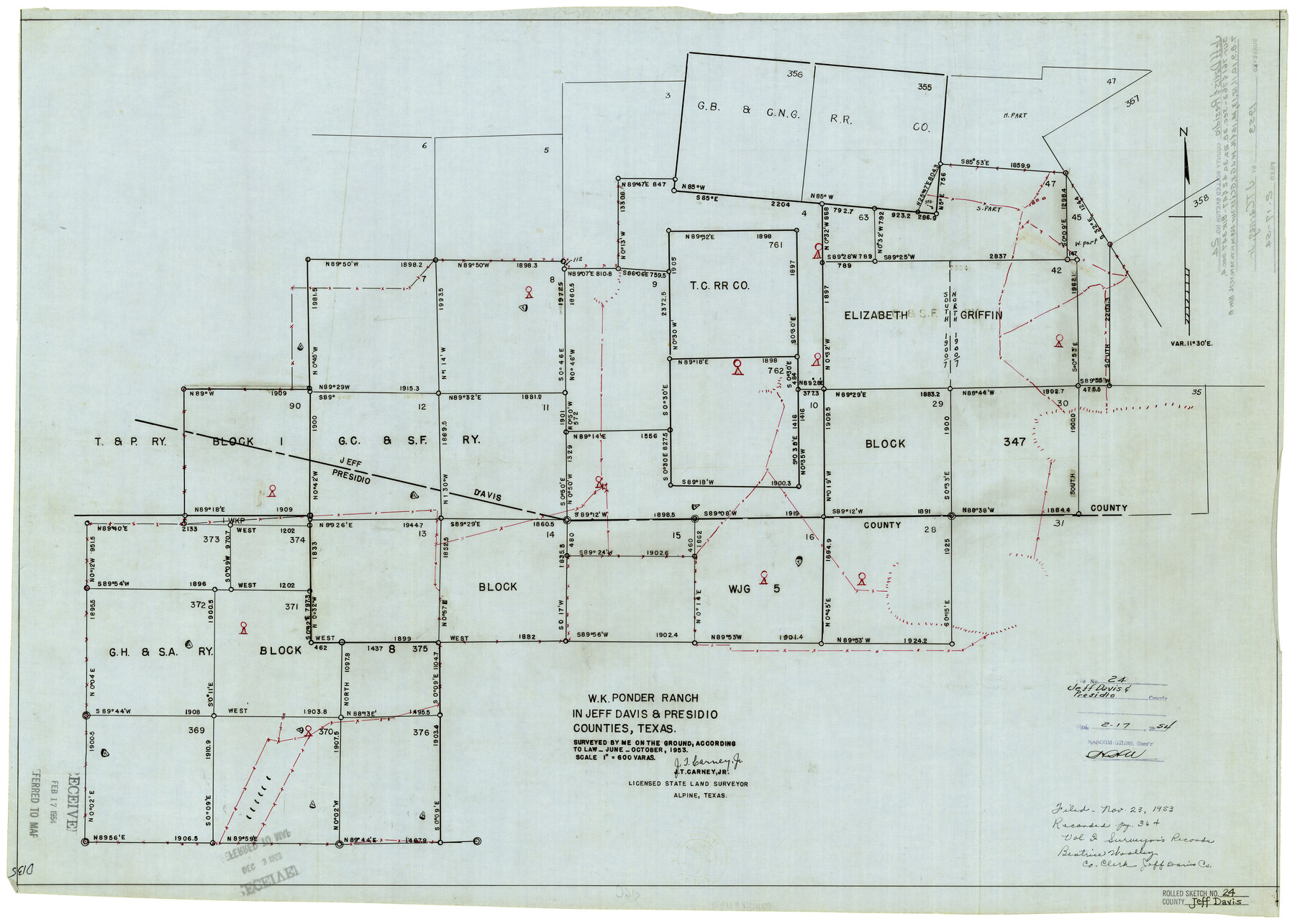
Jeff Davis County Rolled Sketch 24
W.K. Ponder Ranch in Jeff Davis & Presidio Counties, Texas
-
Map/Doc
6372
-
Collection
General Map Collection
-
Object Dates
1953 (Creation Date)
2/17/1954 (File Date)
6-10/1953 (Survey Date)
-
People and Organizations
J.T. Carney, Jr. (Surveyor/Engineer)
-
Counties
Jeff Davis Presidio
-
Subjects
Surveying Rolled Sketch
-
Height x Width
23.2 x 32.5 inches
58.9 x 82.6 cm
-
Medium
linen, manuscript
-
Scale
1" = 600 varas
Part of: General Map Collection
Jefferson County Rolled Sketch 23

Print $20.00
- Digital $50.00
Jefferson County Rolled Sketch 23
1938
Size 45.9 x 33.3 inches
Map/Doc 9289
Jefferson County Rolled Sketch 24

Print $20.00
- Digital $50.00
Jefferson County Rolled Sketch 24
1940
Size 30.3 x 27.8 inches
Map/Doc 6388
Austin County Sketch File 13

Print $40.00
- Digital $50.00
Austin County Sketch File 13
Size 13.9 x 13.2 inches
Map/Doc 10877
Map of Travis County

Print $20.00
- Digital $50.00
Map of Travis County
1861
Size 21.2 x 25.3 inches
Map/Doc 4087
Bastrop County Boundary File 4

Print $48.00
- Digital $50.00
Bastrop County Boundary File 4
1925
Size 11.2 x 8.7 inches
Map/Doc 50324
Terrell County Rolled Sketch 34

Print $20.00
- Digital $50.00
Terrell County Rolled Sketch 34
1937
Size 29.3 x 25.3 inches
Map/Doc 7939
Colorado River, Taiton Sheet

Print $6.00
- Digital $50.00
Colorado River, Taiton Sheet
1941
Size 24.4 x 32.8 inches
Map/Doc 65311
Lipscomb County Boundary File 14b

Print $60.00
- Digital $50.00
Lipscomb County Boundary File 14b
Size 7.3 x 8.7 inches
Map/Doc 56370
Hardin County Sketch File 68

Print $20.00
- Digital $50.00
Hardin County Sketch File 68
1948
Size 23.9 x 21.4 inches
Map/Doc 11640

Flight Mission No. DQN-5K, Frame 78, Calhoun County

Print $20.00
- Digital $50.00
Flight Mission No. DQN-5K, Frame 78, Calhoun County
1953
Size 18.6 x 22.3 inches
Map/Doc 84411
Hudspeth County Rolled Sketch 71

Print $40.00
- Digital $50.00
Hudspeth County Rolled Sketch 71
1992
Size 38.2 x 48.6 inches
Map/Doc 9234
You may also like
Kinney County Rolled Sketch 9

Print $20.00
- Digital $50.00
Kinney County Rolled Sketch 9
Size 39.4 x 27.5 inches
Map/Doc 6538
Dallas County Sketch File 11

Print $12.00
- Digital $50.00
Dallas County Sketch File 11
1860
Size 8.5 x 7.9 inches
Map/Doc 20416
Red River County Working Sketch 47

Print $20.00
- Digital $50.00
Red River County Working Sketch 47
1969
Size 34.3 x 24.2 inches
Map/Doc 72030
Menard County Boundary File 5

Print $8.00
- Digital $50.00
Menard County Boundary File 5
Size 12.7 x 8.1 inches
Map/Doc 57082
Floyd County Boundary File 1

Print $30.00
- Digital $50.00
Floyd County Boundary File 1
Size 8.9 x 4.2 inches
Map/Doc 53445

Harbor Pass and Bar at Brazos Santiago, Texas

Print $20.00
- Digital $50.00
Harbor Pass and Bar at Brazos Santiago, Texas
1871
Size 18.2 x 27.0 inches
Map/Doc 73037
Jasper County Working Sketch 33

Print $20.00
- Digital $50.00
Jasper County Working Sketch 33
1999
Size 30.4 x 17.5 inches
Map/Doc 66495
[Map of Burnet County]
![4512, [Map of Burnet County], General Map Collection](https://historictexasmaps.com/wmedia_w700/maps/4512-2.tif.jpg)
Print $20.00
- Digital $50.00
[Map of Burnet County]
1856
Size 26.3 x 23.1 inches
Map/Doc 4512
Map of Padre Island Showing Location of Zoning Districts

Print $20.00
- Digital $50.00
Map of Padre Island Showing Location of Zoning Districts
1971
Size 18.6 x 26.1 inches
Map/Doc 4810
Flight Mission No. BQR-13K, Frame 20, Brazoria County

Print $20.00
- Digital $50.00
Flight Mission No. BQR-13K, Frame 20, Brazoria County
1952
Size 18.9 x 22.5 inches
Map/Doc 84068
Hunt County Sketch File 34a

Print $4.00
- Digital $50.00
Hunt County Sketch File 34a
1873
Size 8.0 x 10.1 inches
Map/Doc 27146