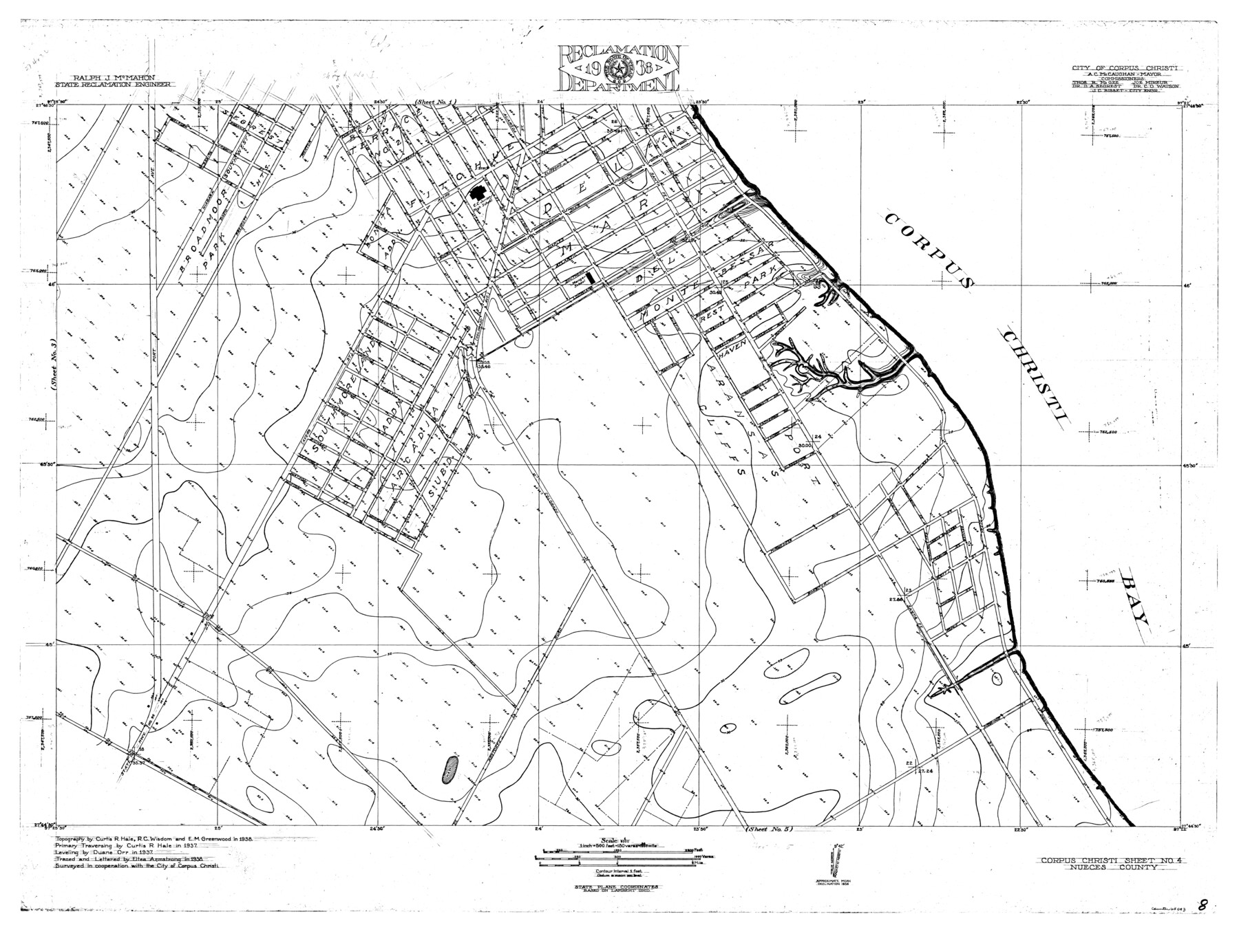
Nueces River, Corpus Christi Sheet No. 4
-
Map/Doc
65093
-
Collection
General Map Collection
-
Object Dates
1938 (Creation Date)
-
People and Organizations
Texas State Reclamation Department (Publisher)
Eltea Armstrong (Draftsman)
Eltea Armstrong (Compiler)
Duane Orr (Surveyor/Engineer)
Curtis R. Hale (Surveyor/Engineer)
R.C. Wisdom (Surveyor/Engineer)
E.M. Greenwood (Surveyor/Engineer)
-
Counties
Nueces
-
Subjects
City River Surveys Topographic
-
Height x Width
31.6 x 41.8 inches
80.3 x 106.2 cm
-
Comments
Corpus Christi Sheet No. 4 located east of the Corpus Christi Sheet No. 3, south of the Corpus Christi Sheet No. 1 and north of the Corpus Christi Sheet No. 5.
Part of: General Map Collection
Briscoe County Sketch File D-1

Print $50.00
- Digital $50.00
Briscoe County Sketch File D-1
1901
Size 9.9 x 6.3 inches
Map/Doc 16406
Cottle County Sketch File 6b

Print $2.00
- Digital $50.00
Cottle County Sketch File 6b
Size 8.8 x 14.1 inches
Map/Doc 19477
Atascosa County Working Sketch 11

Print $20.00
- Digital $50.00
Atascosa County Working Sketch 11
1923
Size 13.9 x 17.1 inches
Map/Doc 67207
Stephens County Working Sketch 19

Print $40.00
- Digital $50.00
Stephens County Working Sketch 19
1969
Size 48.8 x 42.7 inches
Map/Doc 63962
Chambers County Sketch File 27

Print $12.00
- Digital $50.00
Chambers County Sketch File 27
1934
Size 11.3 x 8.8 inches
Map/Doc 17606
Mappa Geographica Complectens I. Indiae Occidentalis Partem Mediam Circum Isthmum Panamensem; II. Ipsumque Isthmum; III. Ichnographiam praecipuorum locorum & portuum ad has terras pertinentium

Print $20.00
- Digital $50.00
Mappa Geographica Complectens I. Indiae Occidentalis Partem Mediam Circum Isthmum Panamensem; II. Ipsumque Isthmum; III. Ichnographiam praecipuorum locorum & portuum ad has terras pertinentium
1740
Size 24.6 x 22.6 inches
Map/Doc 93693
That part of the boundary between the Republic of Texas and the United States, North of Sabine River from the 36th to the 72nd Mile Mound on the Meridian Line (Sheet No. 2)

Print $20.00
- Digital $50.00
That part of the boundary between the Republic of Texas and the United States, North of Sabine River from the 36th to the 72nd Mile Mound on the Meridian Line (Sheet No. 2)
1842
Size 33.7 x 26.0 inches
Map/Doc 3132
Knox County Working Sketch Graphic Index

Print $20.00
- Digital $50.00
Knox County Working Sketch Graphic Index
1923
Size 44.8 x 39.4 inches
Map/Doc 76611
Map of the United States constructed from the latest authorities

Print $20.00
- Digital $50.00
Map of the United States constructed from the latest authorities
1825
Size 19.4 x 24.5 inches
Map/Doc 93924
Nueces County Sketch File 33

Print $20.00
- Digital $50.00
Nueces County Sketch File 33
1908
Size 22.0 x 19.2 inches
Map/Doc 42188
Presidio County Rolled Sketch T-1

Print $20.00
- Digital $50.00
Presidio County Rolled Sketch T-1
Size 26.8 x 27.1 inches
Map/Doc 7416
Archer County Sketch File C

Print $164.00
- Digital $50.00
Archer County Sketch File C
1899
Size 9.0 x 6.2 inches
Map/Doc 13574
You may also like
[Maps of surveys in Reeves & Culberson Cos]
![61142, [Maps of surveys in Reeves & Culberson Cos], General Map Collection](https://historictexasmaps.com/wmedia_w700/maps/61142.tif.jpg)
Print $20.00
- Digital $50.00
[Maps of surveys in Reeves & Culberson Cos]
1937
Size 30.6 x 24.8 inches
Map/Doc 61142
Flight Mission No. DQN-5K, Frame 57, Calhoun County

Print $20.00
- Digital $50.00
Flight Mission No. DQN-5K, Frame 57, Calhoun County
1953
Size 18.9 x 22.4 inches
Map/Doc 84400
Texas Nach den besten Quellen

Print $20.00
- Digital $50.00
Texas Nach den besten Quellen
1846
Size 15.4 x 18.7 inches
Map/Doc 93874
Matagorda County Working Sketch 24

Print $20.00
- Digital $50.00
Matagorda County Working Sketch 24
1972
Size 25.3 x 34.5 inches
Map/Doc 70882
Galveston County Sketch File 73f

Print $20.00
- Digital $50.00
Galveston County Sketch File 73f
Size 33.1 x 40.3 inches
Map/Doc 10459
Flight Mission No. BRE-1P, Frame 47, Nueces County

Print $20.00
- Digital $50.00
Flight Mission No. BRE-1P, Frame 47, Nueces County
1956
Size 18.4 x 22.3 inches
Map/Doc 86636
[In Northwest 1/4 of County in the vicinity of the John Walker Survey]
![90898, [In Northwest 1/4 of County in the vicinity of the John Walker Survey], Twichell Survey Records](https://historictexasmaps.com/wmedia_w700/maps/90898-1.tif.jpg)
Print $20.00
- Digital $50.00
[In Northwest 1/4 of County in the vicinity of the John Walker Survey]
Size 14.4 x 24.3 inches
Map/Doc 90898
Liberty County Working Sketch 73

Print $40.00
- Digital $50.00
Liberty County Working Sketch 73
1978
Size 25.5 x 61.6 inches
Map/Doc 70533
Terrell County Rolled Sketch 53A

Print $20.00
- Digital $50.00
Terrell County Rolled Sketch 53A
Size 32.9 x 24.2 inches
Map/Doc 7972
Baylor County Working Sketch 3

Print $20.00
- Digital $50.00
Baylor County Working Sketch 3
1929
Size 37.8 x 36.5 inches
Map/Doc 67288
Burnet County Working Sketch 10

Print $20.00
- Digital $50.00
Burnet County Working Sketch 10
1975
Size 18.6 x 20.3 inches
Map/Doc 67853
Flight Mission No. BRA-7M, Frame 180, Jefferson County

Print $20.00
- Digital $50.00
Flight Mission No. BRA-7M, Frame 180, Jefferson County
1953
Size 18.7 x 22.4 inches
Map/Doc 85548