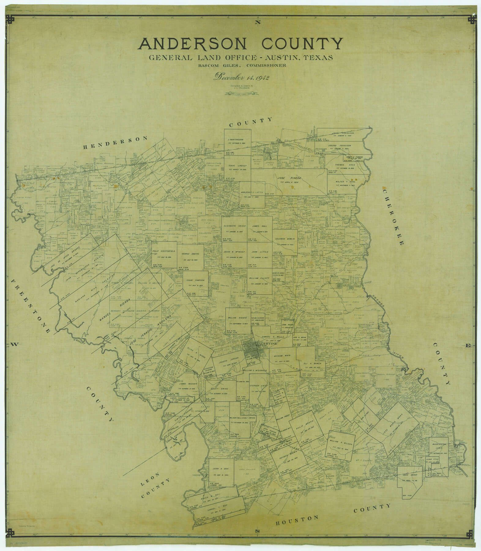
Anderson County
-
Map/Doc
66701
-
Collection
General Map Collection
-
Object Dates
1942/12/14 (Creation Date)
-
People and Organizations
Texas General Land Office (Publisher)
J.L. Woodland (Compiler)
J.L. Woodland (Draftsman)
-
Counties
Anderson
-
Subjects
County
-
Height x Width
54.2 x 47.3 inches
137.7 x 120.1 cm
-
Comments
Traced by Tommye Buie.
Part of: General Map Collection
Jim Wells County Boundary File 3

Print $10.00
- Digital $50.00
Jim Wells County Boundary File 3
Size 9.3 x 6.0 inches
Map/Doc 55546
[Neches River Bed, Plat and Calculations]
![77100, [Neches River Bed, Plat and Calculations], General Map Collection](https://historictexasmaps.com/wmedia_w700/maps/77100.tif.jpg)
Print $20.00
- Digital $50.00
[Neches River Bed, Plat and Calculations]
1928
Size 25.6 x 37.2 inches
Map/Doc 77100
Val Verde County Sketch File Z22

Print $4.00
- Digital $50.00
Val Verde County Sketch File Z22
1919
Size 11.2 x 8.6 inches
Map/Doc 39163
[Sketch for Mineral Application 16700 - Pecos River Bed]
![2811, [Sketch for Mineral Application 16700 - Pecos River Bed], General Map Collection](https://historictexasmaps.com/wmedia_w700/maps/2811.tif.jpg)
Print $20.00
- Digital $50.00
[Sketch for Mineral Application 16700 - Pecos River Bed]
1927
Size 20.6 x 28.6 inches
Map/Doc 2811
Rosebud Station Map -Tracks and Structures - Lands, San Antonio and Aransas Pass Railway Co

Print $4.00
- Digital $50.00
Rosebud Station Map -Tracks and Structures - Lands, San Antonio and Aransas Pass Railway Co
1919
Size 11.7 x 18.6 inches
Map/Doc 62565
Flight Mission No. BRA-9M, Frame 60, Jefferson County

Print $20.00
- Digital $50.00
Flight Mission No. BRA-9M, Frame 60, Jefferson County
1953
Size 18.6 x 22.4 inches
Map/Doc 85643
Chart of the West Indies and Spanish Dominions in North America

Print $20.00
- Digital $50.00
Chart of the West Indies and Spanish Dominions in North America
1803
Size 25.3 x 38.4 inches
Map/Doc 97136
Flight Mission No. DIX-10P, Frame 150, Aransas County

Print $20.00
- Digital $50.00
Flight Mission No. DIX-10P, Frame 150, Aransas County
1956
Size 18.7 x 22.3 inches
Map/Doc 83952
Plot of surveys on Sims Bayou

Print $2.00
- Digital $50.00
Plot of surveys on Sims Bayou
1844
Size 6.8 x 8.3 inches
Map/Doc 26
East Part of Liberty Co.

Print $20.00
- Digital $50.00
East Part of Liberty Co.
1977
Size 41.0 x 30.9 inches
Map/Doc 77352
Sutton County Rolled Sketch 54

Print $20.00
- Digital $50.00
Sutton County Rolled Sketch 54
Size 32.4 x 27.7 inches
Map/Doc 7894
Lavaca County Working Sketch 14

Print $20.00
- Digital $50.00
Lavaca County Working Sketch 14
1962
Size 28.4 x 29.7 inches
Map/Doc 70367
You may also like
Mitchell County Working Sketch 9

Print $20.00
- Digital $50.00
Mitchell County Working Sketch 9
1987
Size 25.8 x 41.1 inches
Map/Doc 71066
Flight Mission No. DAH-9M, Frame 163, Orange County

Print $20.00
- Digital $50.00
Flight Mission No. DAH-9M, Frame 163, Orange County
1953
Size 18.4 x 22.4 inches
Map/Doc 86862
Starr County Rolled Sketch 12

Print $20.00
- Digital $50.00
Starr County Rolled Sketch 12
1912
Size 19.5 x 15.5 inches
Map/Doc 7799
Harris County NRC Article 33.136 Sketch 13

Print $28.00
- Digital $50.00
Harris County NRC Article 33.136 Sketch 13
2009
Size 36.0 x 24.3 inches
Map/Doc 94641
Aransas County Sketch File 21c

Print $4.00
- Digital $50.00
Aransas County Sketch File 21c
Size 8.7 x 14.0 inches
Map/Doc 13162
Rains County Rolled Sketch 1

Print $40.00
- Digital $50.00
Rains County Rolled Sketch 1
1958
Size 42.0 x 65.2 inches
Map/Doc 9806
Duval County Working Sketch 37

Print $20.00
- Digital $50.00
Duval County Working Sketch 37
1958
Size 23.3 x 37.1 inches
Map/Doc 68761
El Paso County Working Sketch 48

Print $20.00
- Digital $50.00
El Paso County Working Sketch 48
1987
Size 32.7 x 29.4 inches
Map/Doc 69070
[Surveys between the Lavaca River and Arenosa Creek]
![3184, [Surveys between the Lavaca River and Arenosa Creek], General Map Collection](https://historictexasmaps.com/wmedia_w700/maps/3184.tif.jpg)
Print $20.00
- Digital $50.00
[Surveys between the Lavaca River and Arenosa Creek]
1840
Size 25.6 x 18.9 inches
Map/Doc 3184
[University Lands Blocks 16-18]
![91568, [University Lands Blocks 16-18], Twichell Survey Records](https://historictexasmaps.com/wmedia_w700/maps/91568-1.tif.jpg)
Print $20.00
- Digital $50.00
[University Lands Blocks 16-18]
Size 18.5 x 12.7 inches
Map/Doc 91568
Mason County Sketch File 11

Print $8.00
- Digital $50.00
Mason County Sketch File 11
1883
Size 13.5 x 8.6 inches
Map/Doc 30695
Denton County Working Sketch 32

Print $20.00
- Digital $50.00
Denton County Working Sketch 32
Size 35.1 x 32.0 inches
Map/Doc 68637