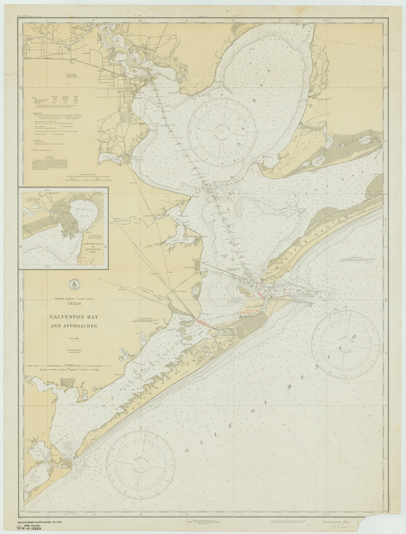
Galveston Bay and Approaches
K-6-1282d
-
Map/Doc
69874
-
Collection
General Map Collection
-
Object Dates
1933 (Creation Date)
-
Counties
Galveston Brazoria Chambers Harris
-
Subjects
Nautical Charts
-
Height x Width
46.0 x 34.9 inches
116.8 x 88.6 cm
Part of: General Map Collection
Flight Mission No. BRA-9M, Frame 71, Jefferson County

Print $20.00
- Digital $50.00
Flight Mission No. BRA-9M, Frame 71, Jefferson County
1953
Size 18.5 x 22.4 inches
Map/Doc 85654
Victoria County Working Sketch 1

Print $20.00
- Digital $50.00
Victoria County Working Sketch 1
1938
Size 33.5 x 36.9 inches
Map/Doc 72271
Hamilton County Working Sketch 32

Print $20.00
- Digital $50.00
Hamilton County Working Sketch 32
1993
Size 26.3 x 34.3 inches
Map/Doc 63370

Lynn County Sketch File 12

Print $4.00
- Digital $50.00
Lynn County Sketch File 12
1907
Size 7.5 x 8.7 inches
Map/Doc 30480
Howard County

Print $20.00
- Digital $50.00
Howard County
1922
Size 41.3 x 35.2 inches
Map/Doc 73185
Throckmorton County Rolled Sketch 6A

Print $20.00
- Digital $50.00
Throckmorton County Rolled Sketch 6A
2004
Size 20.3 x 24.3 inches
Map/Doc 82489
Concho County Sketch File 46

Print $24.00
- Digital $50.00
Concho County Sketch File 46
1961
Size 14.2 x 8.6 inches
Map/Doc 19213
Atascosa County Sketch File 33

Print $40.00
- Digital $50.00
Atascosa County Sketch File 33
1916
Size 24.9 x 19.7 inches
Map/Doc 10865
Tom Green County Sketch File 53

Print $8.00
- Digital $50.00
Tom Green County Sketch File 53
1884
Size 14.2 x 9.1 inches
Map/Doc 38221
Val Verde County Sketch File XXX5

Print $40.00
- Digital $50.00
Val Verde County Sketch File XXX5
Size 13.2 x 13.4 inches
Map/Doc 39100
Wood County Working Sketch 1

Print $20.00
- Digital $50.00
Wood County Working Sketch 1
1904
Size 19.7 x 16.2 inches
Map/Doc 62001
You may also like
Kerr County Working Sketch 33

Print $20.00
- Digital $50.00
Kerr County Working Sketch 33
Size 30.0 x 33.7 inches
Map/Doc 70064

Sterling County Sketch File 11

Print $40.00
- Digital $50.00
Sterling County Sketch File 11
1929
Size 14.2 x 17.2 inches
Map/Doc 37148
Hale County Working Sketch 2

Print $20.00
- Digital $50.00
Hale County Working Sketch 2
1916
Size 13.5 x 13.1 inches
Map/Doc 63322
Terrell County Working Sketch 84b

Print $20.00
- Digital $50.00
Terrell County Working Sketch 84b
1992
Size 25.2 x 42.7 inches
Map/Doc 69606
[E. L. & R. R. RR. Blks. 9 & 10]
![90123, [E. L. & R. R. RR. Blks. 9 & 10], Twichell Survey Records](https://historictexasmaps.com/wmedia_w700/maps/90123-1.tif.jpg)
Print $2.00
- Digital $50.00
[E. L. & R. R. RR. Blks. 9 & 10]
Size 8.7 x 11.3 inches
Map/Doc 90123
Starr County Working Sketch 25

Print $20.00
- Digital $50.00
Starr County Working Sketch 25
1988
Size 38.5 x 27.9 inches
Map/Doc 63941
Rusk County Sketch File 27a

Print $10.00
Rusk County Sketch File 27a
1936
Size 14.2 x 8.8 inches
Map/Doc 35532
Van Zandt County Working Sketch 12

Print $20.00
- Digital $50.00
Van Zandt County Working Sketch 12
1982
Size 21.5 x 20.7 inches
Map/Doc 72262
Runnels County Working Sketch 17

Print $20.00
- Digital $50.00
Runnels County Working Sketch 17
1950
Size 27.1 x 21.5 inches
Map/Doc 63613
Kerr County Sketch File 20

Print $22.00
- Digital $50.00
Kerr County Sketch File 20
1951
Size 12.9 x 18.3 inches
Map/Doc 28890
Flight Mission No. DQN-2K, Frame 95, Calhoun County

Print $20.00
- Digital $50.00
Flight Mission No. DQN-2K, Frame 95, Calhoun County
1953
Size 18.6 x 22.3 inches
Map/Doc 84285