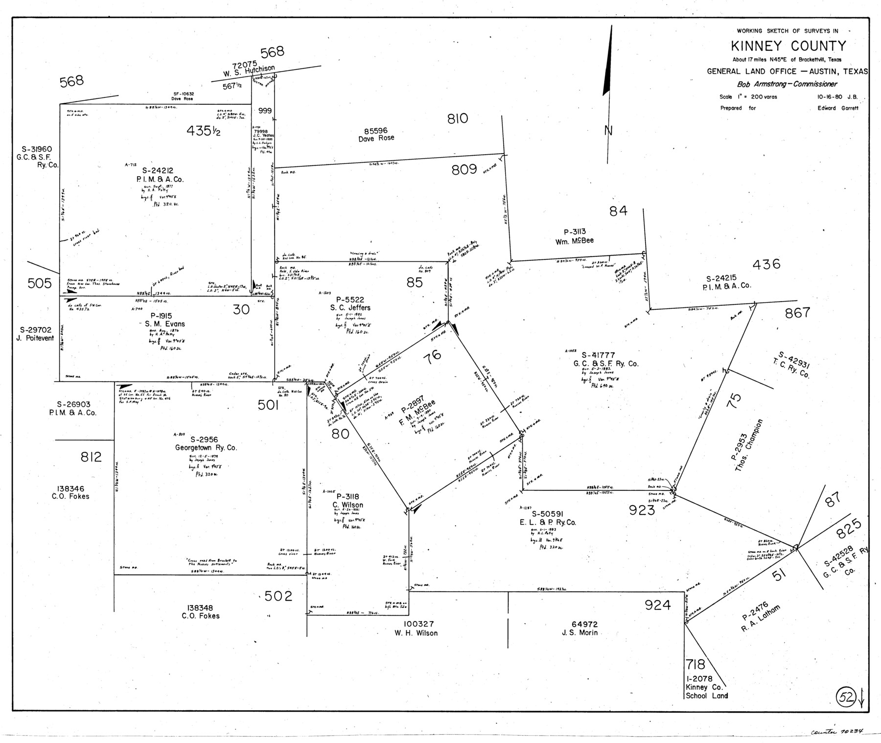
Kinney County Working Sketch 52
-
Map/Doc
70234
-
Collection
General Map Collection
-
Object Dates
10/16/1980 (Creation Date)
-
People and Organizations
Jana Brod (Draftsman)
-
Counties
Kinney
-
Subjects
Surveying Working Sketch
-
Height x Width
26.1 x 31.0 inches
66.3 x 78.7 cm
-
Scale
1" = 200 varas
Part of: General Map Collection
Moore County Rolled Sketch 13

Print $20.00
- Digital $50.00
Moore County Rolled Sketch 13
1920
Size 25.8 x 33.3 inches
Map/Doc 6829
Tyler County Working Sketch 6

Print $20.00
- Digital $50.00
Tyler County Working Sketch 6
1934
Size 24.3 x 36.5 inches
Map/Doc 69476
Flight Mission No. CRC-3R, Frame 49, Chambers County

Print $20.00
- Digital $50.00
Flight Mission No. CRC-3R, Frame 49, Chambers County
1956
Size 18.6 x 22.3 inches
Map/Doc 84822
Flight Mission No. CGI-4N, Frame 191, Cameron County

Print $20.00
- Digital $50.00
Flight Mission No. CGI-4N, Frame 191, Cameron County
1955
Size 18.6 x 22.2 inches
Map/Doc 84694
Live Oak County

Print $40.00
- Digital $50.00
Live Oak County
1899
Size 51.8 x 37.2 inches
Map/Doc 78404
Brewster County Working Sketch 16

Print $20.00
- Digital $50.00
Brewster County Working Sketch 16
1930
Size 42.0 x 40.1 inches
Map/Doc 67550

United States of North America (Eastern and Central)

Print $20.00
- Digital $50.00
United States of North America (Eastern and Central)
1862
Size 19.3 x 26.2 inches
Map/Doc 93667
McLennan County Working Sketch 8

Print $20.00
- Digital $50.00
McLennan County Working Sketch 8
1974
Size 34.1 x 30.6 inches
Map/Doc 70701
Val Verde County Sketch File B2

Print $20.00
- Digital $50.00
Val Verde County Sketch File B2
1910
Size 24.5 x 12.2 inches
Map/Doc 12544
Montgomery County Working Sketch 50

Print $20.00
- Digital $50.00
Montgomery County Working Sketch 50
1959
Size 25.3 x 21.9 inches
Map/Doc 71157

You may also like
Stephens County Working Sketch 7

Print $20.00
- Digital $50.00
Stephens County Working Sketch 7
1919
Size 26.9 x 16.6 inches
Map/Doc 63950
Reeves County

Print $40.00
- Digital $50.00
Reeves County
1945
Size 48.3 x 39.8 inches
Map/Doc 73273

[Movements & Objectives of the 143rd & 144th Infantry on October 12-13, 1918]
![94135, [Movements & Objectives of the 143rd & 144th Infantry on October 12-13, 1918], Non-GLO Digital Images](https://historictexasmaps.com/wmedia_w700/maps/94135-1.tif.jpg)
Print $20.00
[Movements & Objectives of the 143rd & 144th Infantry on October 12-13, 1918]
1918
Size 42.4 x 30.0 inches
Map/Doc 94135
Menard County Working Sketch 30

Print $20.00
- Digital $50.00
Menard County Working Sketch 30
1974
Size 47.9 x 38.8 inches
Map/Doc 70977
Sherman County Sketch File D

Print $5.00
- Digital $50.00
Sherman County Sketch File D
1959
Size 10.6 x 8.9 inches
Map/Doc 36721
Motley County Boundary File 2e

Print $40.00
- Digital $50.00
Motley County Boundary File 2e
Size 29.4 x 96.1 inches
Map/Doc 57561
Navarro County

Print $40.00
- Digital $50.00
Navarro County
1924
Size 42.5 x 49.0 inches
Map/Doc 95599
Calhoun County Rolled Sketch 30

Print $20.00
- Digital $50.00
Calhoun County Rolled Sketch 30
1974
Size 18.6 x 27.2 inches
Map/Doc 5497
Uvalde County Working Sketch 62

Print $20.00
- Digital $50.00
Uvalde County Working Sketch 62
1993
Size 22.5 x 31.4 inches
Map/Doc 72132
[Sketch for Mineral Application 35811 - Liberty County, John Mecom]
![65619, [Sketch for Mineral Application 35811 - Liberty County, John Mecom], General Map Collection](https://historictexasmaps.com/wmedia_w700/maps/65619.tif.jpg)
Print $4.00
- Digital $50.00
[Sketch for Mineral Application 35811 - Liberty County, John Mecom]
1941
Size 24.9 x 20.0 inches
Map/Doc 65619
Hunt County Rolled Sketch 5

Print $20.00
- Digital $50.00
Hunt County Rolled Sketch 5
1956
Size 27.6 x 24.8 inches
Map/Doc 6270