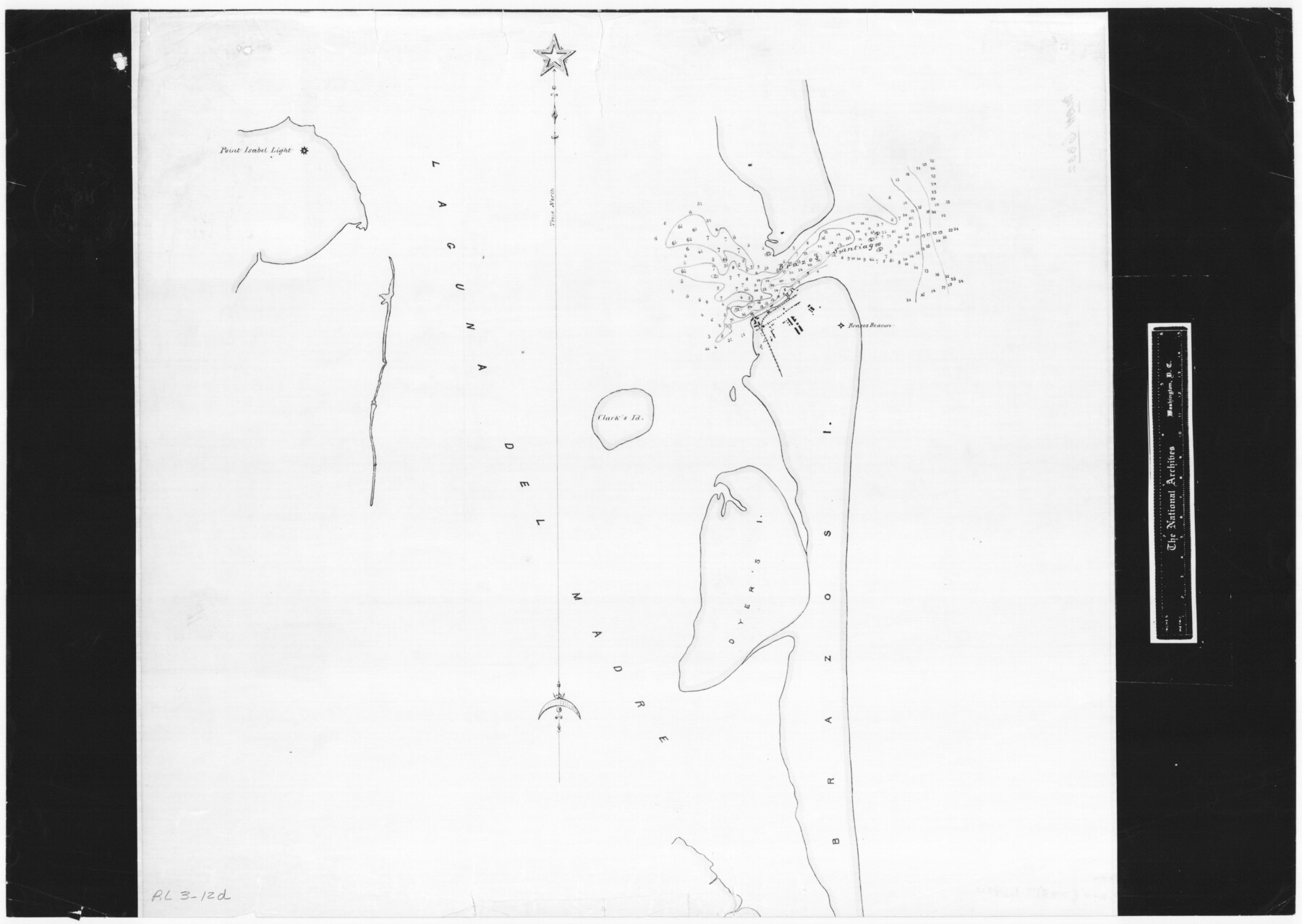
Brazos Santiago & Boca Chica entrances, Texas
RL-3-12d
-
Map/Doc
72928
-
Collection
General Map Collection
-
Object Dates
1867 (Creation Date)
-
People and Organizations
U. S. Coast Survey Office (Author)
-
Subjects
Nautical Charts
-
Height x Width
18.3 x 25.7 inches
46.5 x 65.3 cm
-
Comments
B/W photostat copy from National Archives in multiple pieces.
Part of: General Map Collection
Cass County Rolled Sketch 4

Print $20.00
- Digital $50.00
Cass County Rolled Sketch 4
1946
Size 20.2 x 15.1 inches
Map/Doc 5410
Edwards County Sketch File 12

Print $16.00
- Digital $50.00
Edwards County Sketch File 12
Size 14.6 x 9.1 inches
Map/Doc 21690
Panola County Working Sketch 41

Print $20.00
- Digital $50.00
Panola County Working Sketch 41
1995
Map/Doc 71450
Parmer County Working Sketch 1

Print $20.00
- Digital $50.00
Parmer County Working Sketch 1
1903
Map/Doc 71469
El Paso County Sketch File 18

Print $20.00
- Digital $50.00
El Paso County Sketch File 18
Size 19.0 x 23.8 inches
Map/Doc 11454
Denton County Working Sketch 11

Print $20.00
- Digital $50.00
Denton County Working Sketch 11
1960
Size 26.2 x 20.4 inches
Map/Doc 68616
[Surveys along the Neches River in Jasper District]
![69733, [Surveys along the Neches River in Jasper District], General Map Collection](https://historictexasmaps.com/wmedia_w700/maps/69733.tif.jpg)
Print $2.00
- Digital $50.00
[Surveys along the Neches River in Jasper District]
1847
Size 9.2 x 6.8 inches
Map/Doc 69733
Map of Eagle Lake

Print $20.00
- Digital $50.00
Map of Eagle Lake
1938
Size 13.0 x 17.0 inches
Map/Doc 2208
Jackson County Sketch File 21a

Print $20.00
- Digital $50.00
Jackson County Sketch File 21a
1937
Size 25.7 x 35.4 inches
Map/Doc 11843
Lavaca County Working Sketch 2

Print $20.00
- Digital $50.00
Lavaca County Working Sketch 2
1904
Size 19.2 x 31.2 inches
Map/Doc 70355
Bandera County Rolled Sketch 2

Print $20.00
- Digital $50.00
Bandera County Rolled Sketch 2
1945
Size 19.1 x 24.0 inches
Map/Doc 5114
Edwards County Working Sketch 96

Print $20.00
- Digital $50.00
Edwards County Working Sketch 96
1969
Size 25.1 x 34.1 inches
Map/Doc 68972
You may also like
![90260, [League 271], Twichell Survey Records](https://historictexasmaps.com/wmedia_w700/maps/90260-1.tif.jpg)
Flight Mission No. BQR-3K, Frame 156, Brazoria County

Print $20.00
- Digital $50.00
Flight Mission No. BQR-3K, Frame 156, Brazoria County
1952
Size 18.6 x 22.4 inches
Map/Doc 83983
Denton County Working Sketch 2

Print $20.00
- Digital $50.00
Denton County Working Sketch 2
Size 21.2 x 17.7 inches
Map/Doc 68607
Montague County Sketch File 2

Print $24.00
- Digital $50.00
Montague County Sketch File 2
1856
Size 12.0 x 8.5 inches
Map/Doc 31711
Laguna Madre, Register No. 1477A

Print $40.00
- Digital $50.00
Laguna Madre, Register No. 1477A
1880
Size 34.3 x 56.0 inches
Map/Doc 73606
Brooks County Sketch File 6

Print $12.00
- Digital $50.00
Brooks County Sketch File 6
1941
Size 13.2 x 8.3 inches
Map/Doc 16560
Eastland County Working Sketch 29

Print $20.00
- Digital $50.00
Eastland County Working Sketch 29
1952
Size 21.1 x 22.3 inches
Map/Doc 68810
Jeff Davis County Sketch File 32

Print $20.00
- Digital $50.00
Jeff Davis County Sketch File 32
Size 23.8 x 18.8 inches
Map/Doc 11865
Flight Mission No. CGI-4N, Frame 171, Cameron County

Print $20.00
- Digital $50.00
Flight Mission No. CGI-4N, Frame 171, Cameron County
1955
Size 18.5 x 22.4 inches
Map/Doc 84674
Garza County Rolled Sketch 6C

Print $20.00
- Digital $50.00
Garza County Rolled Sketch 6C
Size 24.7 x 19.2 inches
Map/Doc 5997
Artesian Company Subdivision

Print $20.00
- Digital $50.00
Artesian Company Subdivision
1955
Size 12.0 x 15.8 inches
Map/Doc 92698
McClennan County

Print $20.00
- Digital $50.00
McClennan County
1880
Size 23.3 x 25.3 inches
Map/Doc 4597