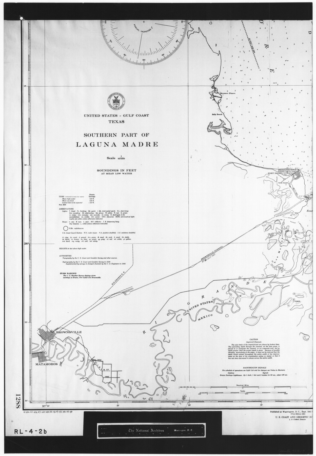
United States - Gulf Coast Texas - Southern part of Laguna Madre
RL-4-2b
-
Map/Doc
72943
-
Collection
General Map Collection
-
Object Dates
1941 (Creation Date)
-
People and Organizations
U. S. Coast and Geodetic Survey (Publisher)
U. S. Coast and Geodetic Survey (Author)
-
Subjects
Nautical Charts
-
Height x Width
26.5 x 18.4 inches
67.3 x 46.7 cm
-
Comments
B/W photostat copy from National Archives in multiple pieces.
Part of: General Map Collection
Sterling County Rolled Sketch X

Print $117.00
- Digital $50.00
Sterling County Rolled Sketch X
Size 15.3 x 9.6 inches
Map/Doc 49097
Glasscock County Working Sketch 17

Print $20.00
- Digital $50.00
Glasscock County Working Sketch 17
1990
Size 27.7 x 30.6 inches
Map/Doc 63190
Topographical Map of the Rio Grande, Sheet No. 5

Print $20.00
- Digital $50.00
Topographical Map of the Rio Grande, Sheet No. 5
1912
Map/Doc 89529
Edwards County Sketch File 24

Print $6.00
- Digital $50.00
Edwards County Sketch File 24
Size 8.9 x 13.2 inches
Map/Doc 21751
Angelina County Working Sketch 46

Print $20.00
- Digital $50.00
Angelina County Working Sketch 46
1976
Size 31.2 x 31.3 inches
Map/Doc 67129
Flight Mission No. DQN-5K, Frame 23, Calhoun County

Print $20.00
- Digital $50.00
Flight Mission No. DQN-5K, Frame 23, Calhoun County
1953
Size 18.5 x 22.1 inches
Map/Doc 84374
Polk County Sketch File 6

Print $4.00
- Digital $50.00
Polk County Sketch File 6
Size 7.1 x 9.4 inches
Map/Doc 34129
Edwards County Working Sketch 71

Print $20.00
- Digital $50.00
Edwards County Working Sketch 71
1957
Size 17.4 x 23.8 inches
Map/Doc 68947
Floyd County Working Sketch 9

Print $20.00
- Digital $50.00
Floyd County Working Sketch 9
1952
Size 31.5 x 35.9 inches
Map/Doc 69188
Flight Mission No. DIX-10P, Frame 183, Aransas County

Print $20.00
- Digital $50.00
Flight Mission No. DIX-10P, Frame 183, Aransas County
1956
Size 18.4 x 22.1 inches
Map/Doc 83973

Flight Mission No. CZW-1R, Frame 165, Hardeman County

Print $20.00
- Digital $50.00
Flight Mission No. CZW-1R, Frame 165, Hardeman County
1956
Size 18.7 x 22.4 inches
Map/Doc 85236
You may also like
Chambers County Rolled Sketch 23

Print $40.00
- Digital $50.00
Chambers County Rolled Sketch 23
1940
Size 36.5 x 49.2 inches
Map/Doc 8591
Phelps's National Map of the United States, a Travellers Guide. Embracing the principal railroads, canals, steamboat & stage routes, throughout the Union

Print $20.00
- Digital $50.00
Phelps's National Map of the United States, a Travellers Guide. Embracing the principal railroads, canals, steamboat & stage routes, throughout the Union
1849
Size 20.9 x 26.3 inches
Map/Doc 95901
El Paso County Sketch File 1

Print $48.00
- Digital $50.00
El Paso County Sketch File 1
1849
Size 8.9 x 8.2 inches
Map/Doc 21883
Map of Parker County

Print $20.00
- Digital $50.00
Map of Parker County
1879
Size 23.9 x 19.0 inches
Map/Doc 3947
[Parts of PSL Blocks B18, B19, B28, B20 and B29]
![91952, [Parts of PSL Blocks B18, B19, B28, B20 and B29], Twichell Survey Records](https://historictexasmaps.com/wmedia_w700/maps/91952-1.tif.jpg)
Print $20.00
- Digital $50.00
[Parts of PSL Blocks B18, B19, B28, B20 and B29]
Size 21.4 x 28.0 inches
Map/Doc 91952
McLennan County Sketch File 41

Print $44.00
- Digital $50.00
McLennan County Sketch File 41
1963
Size 11.1 x 8.6 inches
Map/Doc 31319
Dallas County Boundary File 4a

Print $60.00
- Digital $50.00
Dallas County Boundary File 4a
Size 14.0 x 8.4 inches
Map/Doc 52142
[Eastern part of Culberson County]
![90505, [Eastern part of Culberson County], Twichell Survey Records](https://historictexasmaps.com/wmedia_w700/maps/90505-1.tif.jpg)
Print $20.00
- Digital $50.00
[Eastern part of Culberson County]
Size 29.0 x 40.5 inches
Map/Doc 90505
Hamilton County Boundary File 6

Print $4.00
- Digital $50.00
Hamilton County Boundary File 6
Size 11.2 x 8.6 inches
Map/Doc 54225
Medina County Sketch File 4

Print $6.00
- Digital $50.00
Medina County Sketch File 4
Size 10.0 x 7.4 inches
Map/Doc 31447
Denton County Working Sketch 18

Print $20.00
- Digital $50.00
Denton County Working Sketch 18
1975
Size 24.1 x 38.8 inches
Map/Doc 68623
Frio County Rolled Sketch HM2

Print $20.00
- Digital $50.00
Frio County Rolled Sketch HM2
1935
Size 41.3 x 30.6 inches
Map/Doc 8899