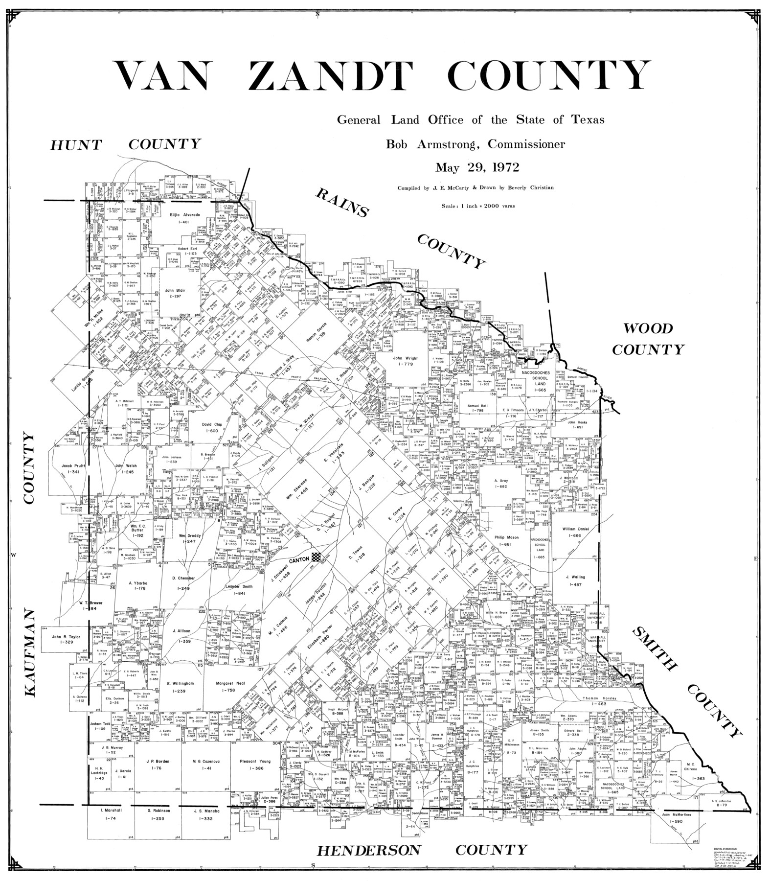
Van Zandt County
-
Map/Doc
77446
-
Collection
General Map Collection
-
Object Dates
1972/5/29 (Creation Date)
-
People and Organizations
Beverly Christian (Draftsman)
J.E. McCarty (Compiler)
-
Counties
Van Zandt
-
Subjects
County
-
Height x Width
45.8 x 40.1 inches
116.3 x 101.9 cm
Part of: General Map Collection
Hardeman County Rolled Sketch 22

Print $20.00
- Digital $50.00
Hardeman County Rolled Sketch 22
Size 25.8 x 18.6 inches
Map/Doc 6073
Terrell County Working Sketch 37

Print $20.00
- Digital $50.00
Terrell County Working Sketch 37
1950
Size 24.5 x 24.1 inches
Map/Doc 62130
La Salle County Rolled Sketch 26

Print $20.00
- Digital $50.00
La Salle County Rolled Sketch 26
1969
Size 23.6 x 24.7 inches
Map/Doc 6587
Zavala County Sketch File 49

Print $10.00
- Digital $50.00
Zavala County Sketch File 49
1955
Size 14.5 x 9.1 inches
Map/Doc 41441
Montgomery County Rolled Sketch 42

Print $20.00
- Digital $50.00
Montgomery County Rolled Sketch 42
1939
Size 14.2 x 20.5 inches
Map/Doc 6817
Williamson County

Print $40.00
- Digital $50.00
Williamson County
1946
Size 39.0 x 56.3 inches
Map/Doc 73326
Map of Titus County

Print $20.00
- Digital $50.00
Map of Titus County
1857
Size 23.8 x 34.3 inches
Map/Doc 4857
Jones County Boundary File 1b

Print $40.00
- Digital $50.00
Jones County Boundary File 1b
1882
Size 37.5 x 12.6 inches
Map/Doc 44359
Crockett County Rolled Sketch 74

Print $20.00
- Digital $50.00
Crockett County Rolled Sketch 74
1949
Size 19.4 x 24.9 inches
Map/Doc 5615
Concho County Working Sketch 8

Print $20.00
- Digital $50.00
Concho County Working Sketch 8
1948
Size 47.0 x 42.6 inches
Map/Doc 68190
Flight Mission No. DCL-6C, Frame 121, Kenedy County

Print $20.00
- Digital $50.00
Flight Mission No. DCL-6C, Frame 121, Kenedy County
1943
Size 18.6 x 22.4 inches
Map/Doc 85951
Mason County Sketch File 8

Print $4.00
- Digital $50.00
Mason County Sketch File 8
1876
Size 13.2 x 8.4 inches
Map/Doc 30691
You may also like

Fannin County Boundary File 1

Print $14.00
- Digital $50.00
Fannin County Boundary File 1
Size 13.2 x 8.6 inches
Map/Doc 53272
[Blocks 3, Q, and Vicinity]
![91276, [Blocks 3, Q, and Vicinity], Twichell Survey Records](https://historictexasmaps.com/wmedia_w700/maps/91276.tif.jpg)
Print $20.00
- Digital $50.00
[Blocks 3, Q, and Vicinity]
Size 19.1 x 9.2 inches
Map/Doc 91276
Flight Mission No. CRC-4R, Frame 63, Chambers County

Print $20.00
- Digital $50.00
Flight Mission No. CRC-4R, Frame 63, Chambers County
1956
Size 18.7 x 22.4 inches
Map/Doc 84867
Harris County Rolled Sketch WDC

Print $40.00
- Digital $50.00
Harris County Rolled Sketch WDC
1936
Size 42.7 x 68.4 inches
Map/Doc 9126
General Highway Map, Travis County, Texas

Print $20.00
General Highway Map, Travis County, Texas
1940
Size 18.3 x 24.9 inches
Map/Doc 79261

Edwards County Sketch File 16a

Print $24.00
- Digital $50.00
Edwards County Sketch File 16a
1903
Size 14.3 x 8.8 inches
Map/Doc 21720
State of Texas

Print $40.00
- Digital $50.00
State of Texas
1965
Size 42.8 x 52.5 inches
Map/Doc 2095
Flight Mission No. DCL-7C, Frame 15, Kenedy County

Print $20.00
- Digital $50.00
Flight Mission No. DCL-7C, Frame 15, Kenedy County
1943
Size 15.4 x 15.3 inches
Map/Doc 86007
Jim Hogg County Sketch File 4

Print $8.00
- Digital $50.00
Jim Hogg County Sketch File 4
1926
Size 11.2 x 8.7 inches
Map/Doc 28404
Maverick County Working Sketch Graphic Index

Print $20.00
- Digital $50.00
Maverick County Working Sketch Graphic Index
1947
Size 46.4 x 30.3 inches
Map/Doc 76635