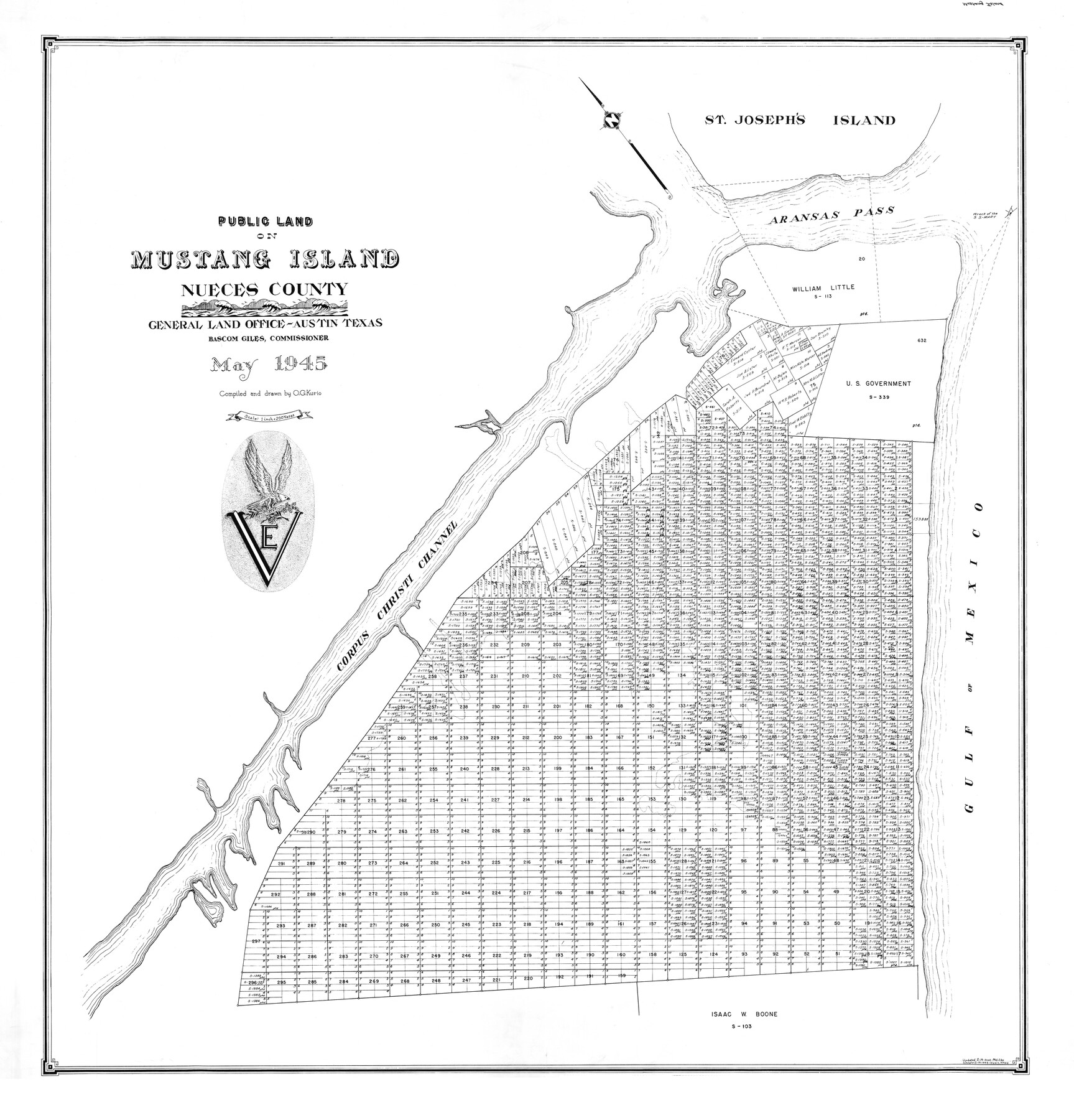
Mustang Island
-
Map/Doc
77469
-
Collection
General Map Collection
-
Object Dates
5/1945 (Creation Date)
-
Counties
Nueces
-
Height x Width
42.8 x 42.6 inches
108.7 x 108.2 cm
-
Medium
mylar
Part of: General Map Collection
Township 1 North Range 11 West, North Western District, Louisiana

Print $20.00
- Digital $50.00
Township 1 North Range 11 West, North Western District, Louisiana
1884
Size 19.6 x 24.7 inches
Map/Doc 65878
Erath County Working Sketch 12

Print $20.00
- Digital $50.00
Erath County Working Sketch 12
1964
Size 22.3 x 23.1 inches
Map/Doc 69093
Garza County Rolled Sketch 11B

Print $20.00
- Digital $50.00
Garza County Rolled Sketch 11B
1915
Size 24.6 x 24.8 inches
Map/Doc 6001
Flight Mission No. BQY-4M, Frame 30, Harris County

Print $20.00
- Digital $50.00
Flight Mission No. BQY-4M, Frame 30, Harris County
1953
Size 18.7 x 22.4 inches
Map/Doc 85245
Current Miscellaneous File 38

Print $8.00
- Digital $50.00
Current Miscellaneous File 38
Size 8.6 x 13.0 inches
Map/Doc 73958
Flight Mission No. CGI-3N, Frame 139, Cameron County

Print $20.00
- Digital $50.00
Flight Mission No. CGI-3N, Frame 139, Cameron County
1954
Size 18.7 x 22.3 inches
Map/Doc 84612
San Jacinto River, Houston Ship Channel

Print $2.00
- Digital $50.00
San Jacinto River, Houston Ship Channel
1939
Size 11.7 x 17.7 inches
Map/Doc 65150
Flight Mission No. CGI-1N, Frame 144, Cameron County

Print $20.00
- Digital $50.00
Flight Mission No. CGI-1N, Frame 144, Cameron County
1955
Size 18.7 x 22.3 inches
Map/Doc 84500
Cherokee County

Print $40.00
- Digital $50.00
Cherokee County
1933
Size 54.7 x 38.7 inches
Map/Doc 73104
Menard County Sketch File 8

Print $20.00
- Digital $50.00
Menard County Sketch File 8
Size 19.7 x 28.5 inches
Map/Doc 12073
Brewster County Rolled Sketch 122

Print $20.00
- Digital $50.00
Brewster County Rolled Sketch 122
1974
Size 31.9 x 24.6 inches
Map/Doc 5298
Bee County Sketch File 32

Print $4.00
- Digital $50.00
Bee County Sketch File 32
Size 7.9 x 12.6 inches
Map/Doc 14347
You may also like
Flight Mission No. BQY-14M, Frame 184, Harris County

Print $20.00
- Digital $50.00
Flight Mission No. BQY-14M, Frame 184, Harris County
1953
Size 18.6 x 22.4 inches
Map/Doc 85300
Laguna Madre, T-9211

Print $20.00
- Digital $50.00
Laguna Madre, T-9211
Size 33.0 x 31.1 inches
Map/Doc 73602
Terrell County Working Sketch 55

Print $20.00
- Digital $50.00
Terrell County Working Sketch 55
1959
Size 25.9 x 43.4 inches
Map/Doc 62148
Crosby County Sketch File 18

Print $26.00
- Digital $50.00
Crosby County Sketch File 18
1905
Size 14.2 x 8.5 inches
Map/Doc 20071
Map of Escarpment Section through Webb County, Texas (North half of Webb County)

Print $40.00
- Digital $50.00
Map of Escarpment Section through Webb County, Texas (North half of Webb County)
1925
Size 43.3 x 76.3 inches
Map/Doc 93162
[Blocks 34-36, Township 1N]
![92032, [Blocks 34-36, Township 1N], Twichell Survey Records](https://historictexasmaps.com/wmedia_w700/maps/92032-1.tif.jpg)
Print $20.00
- Digital $50.00
[Blocks 34-36, Township 1N]
Size 37.0 x 24.0 inches
Map/Doc 92032
Bell County Sketch File 3

Print $4.00
- Digital $50.00
Bell County Sketch File 3
1848
Size 12.6 x 8.4 inches
Map/Doc 14367
Van Zandt County Sketch File 32a

Print $4.00
- Digital $50.00
Van Zandt County Sketch File 32a
1860
Size 12.3 x 8.1 inches
Map/Doc 39467
Robertson County Working Sketch 14

Print $40.00
- Digital $50.00
Robertson County Working Sketch 14
1988
Size 48.6 x 39.6 inches
Map/Doc 63587
Medina County Rolled Sketch 22

Print $20.00
- Digital $50.00
Medina County Rolled Sketch 22
2007
Size 24.5 x 18.4 inches
Map/Doc 88849
Map of Bowie County

Print $20.00
- Digital $50.00
Map of Bowie County
1884
Size 19.4 x 23.7 inches
Map/Doc 3319
J. De Cordova's Map of the State of Texas Compiled from the records of the General Land Office of the State

Print $20.00
- Digital $50.00
J. De Cordova's Map of the State of Texas Compiled from the records of the General Land Office of the State
Size 38.5 x 36.4 inches
Map/Doc 93984