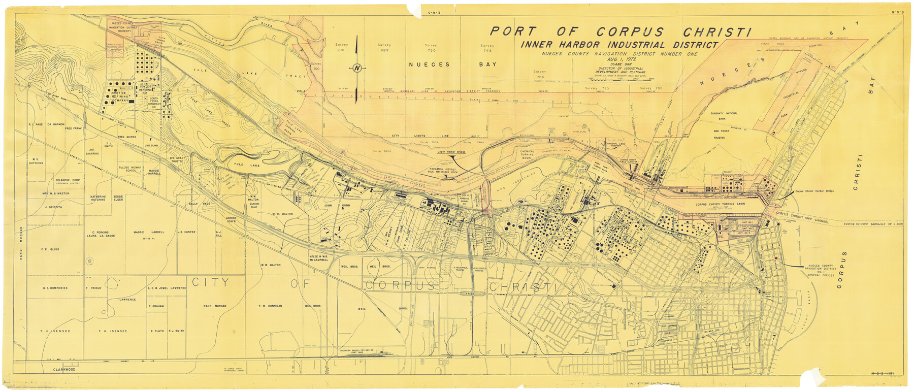
Part of Corpus Christi Inner Harbor Industrial District, Nueces County Navigation District Number One
E-6-5
-
Map/Doc
78635
-
Collection
General Map Collection
-
Object Dates
8/1/1972 (Creation Date)
-
People and Organizations
Nueces County Navigation District No. 1 (Author)
-
Counties
Nueces
-
Subjects
Cadastral City Nautical Charts
-
Height x Width
43.6 x 101.3 inches
110.7 x 257.3 cm
-
Comments
Port of Corpus Christi Ownership Map of Inner Harbor Industrial District
Part of: General Map Collection
Panola County Working Sketch 12

Print $20.00
- Digital $50.00
Panola County Working Sketch 12
Size 18.7 x 40.3 inches
Map/Doc 71421
Loving County Working Sketch 2

Print $20.00
- Digital $50.00
Loving County Working Sketch 2
Size 33.9 x 42.5 inches
Map/Doc 70634
Terrell County Sketch File 22A

Print $20.00
- Digital $50.00
Terrell County Sketch File 22A
Size 21.7 x 11.4 inches
Map/Doc 12422
Nueces County Working Sketch 9

Print $20.00
- Digital $50.00
Nueces County Working Sketch 9
Size 36.1 x 24.1 inches
Map/Doc 71311
Dallas County Working Sketch 4

Print $20.00
- Digital $50.00
Dallas County Working Sketch 4
1935
Size 24.1 x 30.4 inches
Map/Doc 68570

Newton County Rolled Sketch 20

Print $40.00
- Digital $50.00
Newton County Rolled Sketch 20
1956
Size 41.4 x 48.0 inches
Map/Doc 9581
Fort Bend County Sketch File 9a

Print $15.00
- Digital $50.00
Fort Bend County Sketch File 9a
Size 14.6 x 8.9 inches
Map/Doc 22897
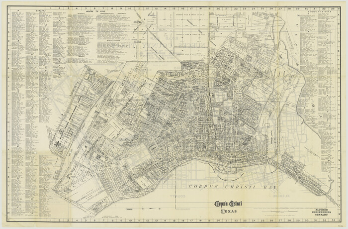
Blucher's Directory Map of Corpus Christi and Road Map of Nueces County
Print $20.00
- Digital $50.00
Blucher's Directory Map of Corpus Christi and Road Map of Nueces County
1945
Size 22.6 x 34.3 inches
Map/Doc 94106
Hudspeth County Working Sketch 21

Print $20.00
- Digital $50.00
Hudspeth County Working Sketch 21
Size 22.8 x 41.6 inches
Map/Doc 66303
Flight Mission No. BRA-7M, Frame 133, Jefferson County

Print $20.00
- Digital $50.00
Flight Mission No. BRA-7M, Frame 133, Jefferson County
1953
Size 18.6 x 22.3 inches
Map/Doc 85527
Hemphill County Working Sketch 37

Print $4.00
- Digital $50.00
Hemphill County Working Sketch 37
Size 28.6 x 24.0 inches
Map/Doc 66132
You may also like
Right of Way and Track Map of The Wichita Falls & Southern Railroad Company

Print $40.00
- Digital $50.00
Right of Way and Track Map of The Wichita Falls & Southern Railroad Company
1942
Size 24.5 x 56.3 inches
Map/Doc 64517
Hutchinson County Rolled Sketch 36B

Print $20.00
- Digital $50.00
Hutchinson County Rolled Sketch 36B
1888
Size 21.1 x 25.3 inches
Map/Doc 6295
Wichita County Working Sketch 14

Print $20.00
- Digital $50.00
Wichita County Working Sketch 14
Size 20.8 x 42.1 inches
Map/Doc 72524
Mills County Boundary File 4

Print $40.00
- Digital $50.00
Mills County Boundary File 4
Size 52.1 x 13.3 inches
Map/Doc 57293
General Highway Map, Guadalupe County, Texas

Print $20.00
General Highway Map, Guadalupe County, Texas
1940
Size 18.6 x 25.1 inches
Map/Doc 79107
Stephen F. Austin Park

Print $20.00
- Digital $50.00
Stephen F. Austin Park
1950
Size 24.7 x 36.9 inches
Map/Doc 73568
Culberson County Working Sketch 90

Print $6.00
- Digital $50.00
Culberson County Working Sketch 90
1992
Size 35.0 x 28.0 inches
Map/Doc 68544
McLennan County Sketch File 43

Print $4.00
- Digital $50.00
McLennan County Sketch File 43
1873
Size 10.0 x 8.1 inches
Map/Doc 31333
Cameron County Rolled Sketch 27

Print $20.00
- Digital $50.00
Cameron County Rolled Sketch 27
Size 19.0 x 39.5 inches
Map/Doc 5392
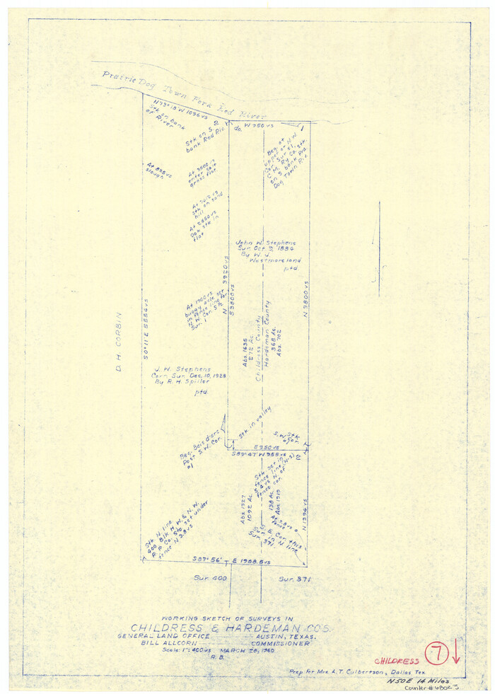
Childress County Working Sketch 7
Print $20.00
- Digital $50.00
Childress County Working Sketch 7
1960
Size 20.7 x 14.8 inches
Map/Doc 68023
El Paso County Boundary File 4a

Print $44.00
- Digital $50.00
El Paso County Boundary File 4a
Size 14.1 x 8.6 inches
Map/Doc 53044