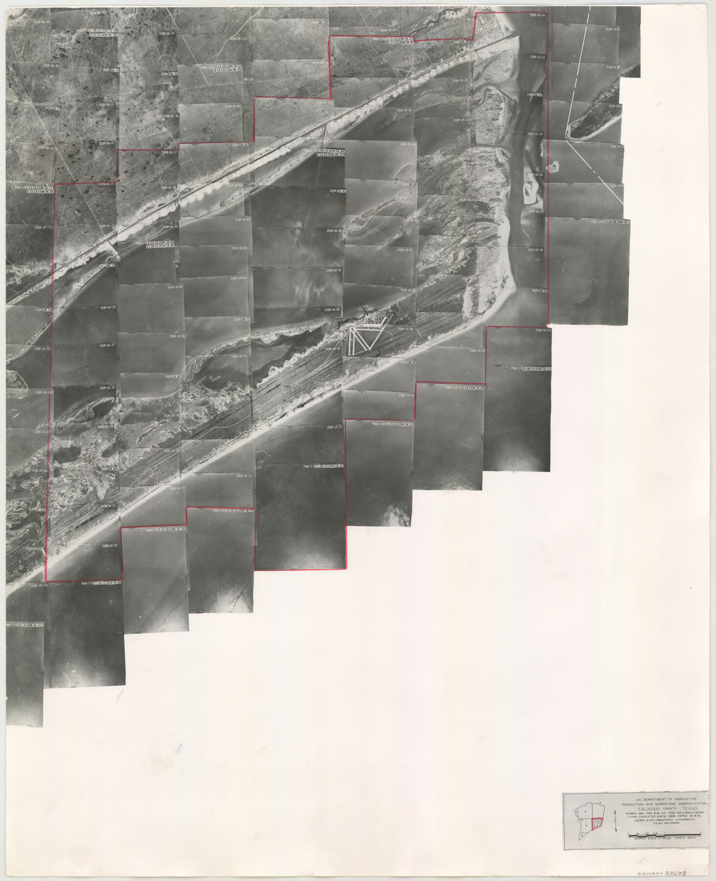
Calhoun County Aerial Photograph Index Sheet 5
Calhoun County Aerial Photograph Index 5
-
Map/Doc
83673
-
Collection
General Map Collection
-
Object Dates
1953/12/15 (Creation Date)
-
People and Organizations
U. S. Department of Agriculture (Publisher)
-
Counties
Calhoun
-
Subjects
Aerial Photograph
-
Height x Width
24.0 x 19.5 inches
61.0 x 49.5 cm
-
Comments
Flying completed December 6, 1953 by Aero Exploration Company of Tulsa, Oklahoma.
Part of: General Map Collection
Karnes County Working Sketch 10

Print $20.00
- Digital $50.00
Karnes County Working Sketch 10
1970
Size 35.5 x 26.3 inches
Map/Doc 66658
Tyler County Sketch File 7a

Print $7.00
- Digital $50.00
Tyler County Sketch File 7a
1874
Size 10.3 x 8.1 inches
Map/Doc 38639
Pecos County Working Sketch 41

Print $20.00
- Digital $50.00
Pecos County Working Sketch 41
1942
Size 19.0 x 31.7 inches
Map/Doc 71513
Galveston County Sketch File 68

Print $62.00
- Digital $50.00
Galveston County Sketch File 68
Size 4.4 x 9.7 inches
Map/Doc 23784
Flight Mission No. DQO-7K, Frame 77, Galveston County

Print $20.00
- Digital $50.00
Flight Mission No. DQO-7K, Frame 77, Galveston County
1952
Size 18.9 x 22.6 inches
Map/Doc 85104
Blanco County Working Sketch 3

Print $20.00
- Digital $50.00
Blanco County Working Sketch 3
Size 14.4 x 16.1 inches
Map/Doc 78189
Caldwell County Working Sketch Graphic Index

Print $20.00
- Digital $50.00
Caldwell County Working Sketch Graphic Index
1935
Size 36.7 x 41.3 inches
Map/Doc 76483
Jasper County Boundary File 1

Print $50.00
- Digital $50.00
Jasper County Boundary File 1
Size 12.6 x 20.5 inches
Map/Doc 55462
Val Verde County Sketch File 19

Print $4.00
- Digital $50.00
Val Verde County Sketch File 19
1858
Size 13.0 x 8.1 inches
Map/Doc 39229
Archer County Sketch File 28-2

Print $40.00
- Digital $50.00
Archer County Sketch File 28-2
Size 21.4 x 16.9 inches
Map/Doc 10835
Brewster County Sketch File 15

Print $120.00
- Digital $50.00
Brewster County Sketch File 15
1935
Size 14.2 x 8.8 inches
Map/Doc 15758
Baylor County Sketch File 15

Print $6.00
- Digital $50.00
Baylor County Sketch File 15
1879
Size 13.0 x 8.4 inches
Map/Doc 14183
You may also like
Maverick County Sketch File 23

Print $7.00
- Digital $50.00
Maverick County Sketch File 23
Size 9.1 x 8.5 inches
Map/Doc 31142
Flight Mission No. CGI-1N, Frame 169, Cameron County

Print $20.00
- Digital $50.00
Flight Mission No. CGI-1N, Frame 169, Cameron County
1955
Size 18.6 x 22.2 inches
Map/Doc 84504
Val Verde County Working Sketch 9

Print $20.00
- Digital $50.00
Val Verde County Working Sketch 9
1917
Size 19.4 x 30.9 inches
Map/Doc 72144
Brown County Sketch File 24

Print $6.00
- Digital $50.00
Brown County Sketch File 24
1889
Size 11.7 x 15.9 inches
Map/Doc 11022
Concho County Rolled Sketch 3

Print $40.00
- Digital $50.00
Concho County Rolled Sketch 3
1949
Size 67.0 x 46.0 inches
Map/Doc 8648
Orange County Working Sketch 32

Print $20.00
- Digital $50.00
Orange County Working Sketch 32
1956
Size 22.9 x 31.7 inches
Map/Doc 71364
[Area around R. H. Hibbett and Geo. W. Lawrence surveys on Elm Fork of the Brazos River]
![90861, [Area around R. H. Hibbett and Geo. W. Lawrence surveys on Elm Fork of the Brazos River], Twichell Survey Records](https://historictexasmaps.com/wmedia_w700/maps/90861-2.tif.jpg)
Print $20.00
- Digital $50.00
[Area around R. H. Hibbett and Geo. W. Lawrence surveys on Elm Fork of the Brazos River]
1901
Size 23.6 x 32.4 inches
Map/Doc 90861
Starr County Sketch File 10

Print $40.00
- Digital $50.00
Starr County Sketch File 10
Size 12.6 x 15.0 inches
Map/Doc 36863
Webb County Boundary File 3b

Print $82.00
- Digital $50.00
Webb County Boundary File 3b
Size 20.3 x 50.8 inches
Map/Doc 59758
Llano County Boundary File 1a

Print $44.00
- Digital $50.00
Llano County Boundary File 1a
Size 13.2 x 8.1 inches
Map/Doc 56430
General Highway Map, Liberty County, Texas

Print $20.00
General Highway Map, Liberty County, Texas
1961
Size 18.2 x 24.7 inches
Map/Doc 79570
Bosque County Sketch File 14

Print $22.00
- Digital $50.00
Bosque County Sketch File 14
1863
Size 12.2 x 7.6 inches
Map/Doc 14763