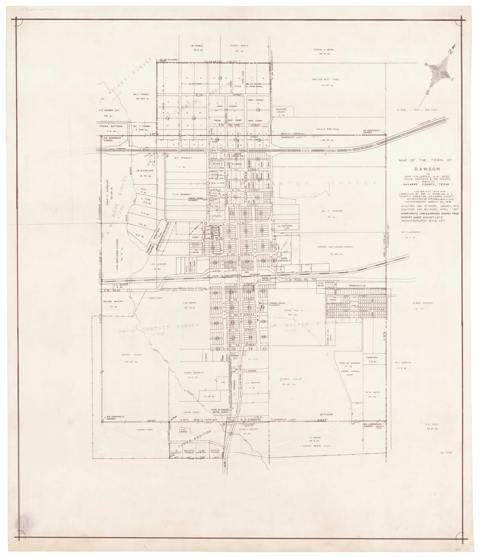
Map of the Town of Dawson in John Fullerton, G. W. Rose, David Onstott and Wm. Walker Surveys
-
Map/Doc
93672
-
Collection
General Map Collection
-
Object Dates
1975/10/29 (Creation Date)
2014/4/8 (File Date)
-
People and Organizations
William V. Mowlam (Compiler)
William V. Mowlam (Surveyor/Engineer)
-
Counties
Navarro
-
Subjects
City
-
Height x Width
43.1 x 37.1 inches
109.5 x 94.2 cm
-
Comments
Reflects revisions through October 29, 1975
Part of: General Map Collection
El Paso County Sketch File 17

Print $20.00
- Digital $50.00
El Paso County Sketch File 17
1885
Size 20.1 x 30.9 inches
Map/Doc 11453
Parker County Sketch File D

Print $4.00
- Digital $50.00
Parker County Sketch File D
Size 9.9 x 8.2 inches
Map/Doc 33514
[Surveys in the Jefferson District]
![275, [Surveys in the Jefferson District], General Map Collection](https://historictexasmaps.com/wmedia_w700/maps/275.tif.jpg)
Print $2.00
- Digital $50.00
[Surveys in the Jefferson District]
1841
Size 8.3 x 8.0 inches
Map/Doc 275
Map of Erath County

Print $40.00
- Digital $50.00
Map of Erath County
1896
Size 49.6 x 43.5 inches
Map/Doc 4943

Jones County Sketch File 7

Print $20.00
- Digital $50.00
Jones County Sketch File 7
Size 12.5 x 27.5 inches
Map/Doc 11897
Flight Mission No. CLL-3N, Frame 36, Willacy County

Print $20.00
- Digital $50.00
Flight Mission No. CLL-3N, Frame 36, Willacy County
1954
Size 18.4 x 22.2 inches
Map/Doc 87094
Wood County Working Sketch 4

Print $20.00
- Digital $50.00
Wood County Working Sketch 4
1941
Size 21.0 x 28.3 inches
Map/Doc 62004
Sutton County Sketch File 18

Print $94.00
- Digital $50.00
Sutton County Sketch File 18
1893
Size 12.9 x 8.3 inches
Map/Doc 37410

Flight Mission No. CRC-2R, Frame 55, Chambers County

Print $20.00
- Digital $50.00
Flight Mission No. CRC-2R, Frame 55, Chambers County
1956
Size 18.7 x 22.4 inches
Map/Doc 84728
Brazoria County Sketch File 45

Print $20.00
- Digital $50.00
Brazoria County Sketch File 45
1980
Size 32.0 x 43.1 inches
Map/Doc 10326
You may also like
Young County Rolled Sketch 8

Print $20.00
- Digital $50.00
Young County Rolled Sketch 8
Size 40.5 x 25.8 inches
Map/Doc 8296
[Pencil sketch showing area between sections 1102, 1101, 1111, and 1112 on the west and sections 3-6 on the east]
![90365, [Pencil sketch showing area between sections 1102, 1101, 1111, and 1112 on the west and sections 3-6 on the east], Twichell Survey Records](https://historictexasmaps.com/wmedia_w700/maps/90365-1.tif.jpg)
Print $2.00
- Digital $50.00
[Pencil sketch showing area between sections 1102, 1101, 1111, and 1112 on the west and sections 3-6 on the east]
Size 5.1 x 8.1 inches
Map/Doc 90365
Harris County Working Sketch 23

Print $20.00
- Digital $50.00
Harris County Working Sketch 23
1926
Size 14.0 x 20.0 inches
Map/Doc 65915
Brazoria County Sketch File 58

Print $30.00
- Digital $50.00
Brazoria County Sketch File 58
1992
Size 11.5 x 9.0 inches
Map/Doc 15382
Hamilton County Working Sketch 6

Print $20.00
- Digital $50.00
Hamilton County Working Sketch 6
1942
Size 21.7 x 20.1 inches
Map/Doc 63344
Flight Mission No. DCL-5C, Frame 74, Kenedy County

Print $20.00
- Digital $50.00
Flight Mission No. DCL-5C, Frame 74, Kenedy County
1943
Size 18.6 x 22.3 inches
Map/Doc 85857
Map of R. H. Welder Ranch, San Patricio County, Texas

Print $40.00
- Digital $50.00
Map of R. H. Welder Ranch, San Patricio County, Texas
1953
Size 30.0 x 61.4 inches
Map/Doc 61406
Hardin County Working Sketch 38

Print $20.00
- Digital $50.00
Hardin County Working Sketch 38
1981
Size 37.2 x 19.4 inches
Map/Doc 63436
Zapata County Sketch File 11

Print $6.00
- Digital $50.00
Zapata County Sketch File 11
1918
Size 14.4 x 8.7 inches
Map/Doc 40946
Reagan County Boundary File 1b

Print $38.00
- Digital $50.00
Reagan County Boundary File 1b
Size 9.3 x 8.3 inches
Map/Doc 58161
Limestone Co.

Print $20.00
- Digital $50.00
Limestone Co.
1971
Size 40.6 x 27.5 inches
Map/Doc 77354
Map of the Galveston, La Porte & Houston Ry. and its Connecting Lines

Print $20.00
- Digital $50.00
Map of the Galveston, La Porte & Houston Ry. and its Connecting Lines
1895
Size 42.6 x 32.0 inches
Map/Doc 64772