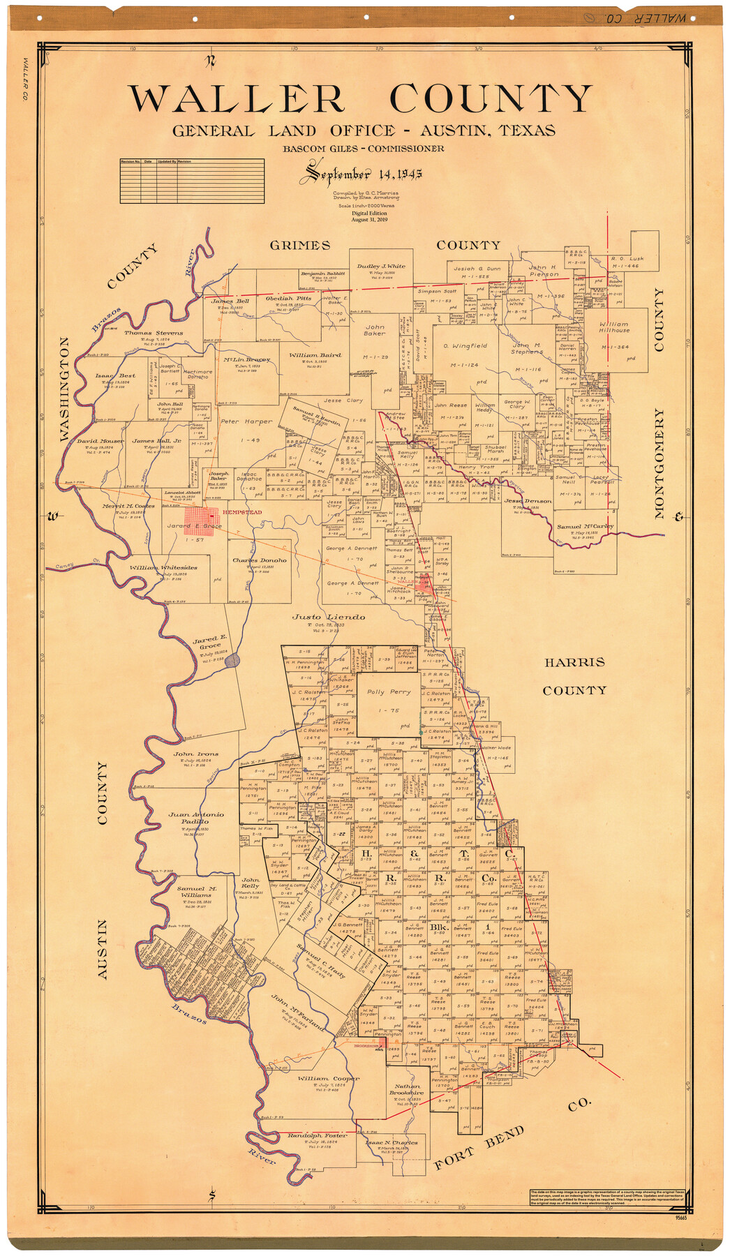
Waller County
General Land Office Official County Map
-
Map/Doc
95665
-
Collection
General Map Collection
-
Object Dates
2019/8/31 (Revision Date)
1945/9/14 (Creation Date)
-
People and Organizations
Cheyenne Betancourt (Draftsman)
Eltea Armstrong (Draftsman)
G.C. Morriss (Compiler)
Bascom Giles (GLO Commissioner)
-
Counties
Waller
-
Subjects
County OCM
-
Height x Width
48.9 x 28.4 inches
124.2 x 72.1 cm
-
Medium
digital image
-
Scale
1" = 2000 varas
Part of: General Map Collection
Knox County Sketch File 24

Print $6.00
- Digital $50.00
Knox County Sketch File 24
1945
Size 14.2 x 9.0 inches
Map/Doc 29254
Culberson County Sketch File 41

Print $20.00
- Digital $50.00
Culberson County Sketch File 41
1920
Size 12.5 x 8.8 inches
Map/Doc 20312
Hays County Boundary File 2a

Print $40.00
- Digital $50.00
Hays County Boundary File 2a
Size 9.0 x 25.0 inches
Map/Doc 54595
Cottle County Working Sketch 14B

Print $20.00
- Digital $50.00
Cottle County Working Sketch 14B
1963
Size 35.2 x 41.6 inches
Map/Doc 61795
Garza County Rolled Sketch 6E

Print $20.00
- Digital $50.00
Garza County Rolled Sketch 6E
1913
Size 19.2 x 15.6 inches
Map/Doc 5999
Map of the West Part of Tom Green County

Print $20.00
- Digital $50.00
Map of the West Part of Tom Green County
1894
Size 46.9 x 34.7 inches
Map/Doc 63072
Upton County Sketch File 45A

Print $8.00
- Digital $50.00
Upton County Sketch File 45A
2001
Size 11.3 x 8.8 inches
Map/Doc 38945
Andrews County Sketch File 6

Print $9.00
- Digital $50.00
Andrews County Sketch File 6
1942
Size 9.6 x 10.6 inches
Map/Doc 12825
Flight Mission No. CLL-1N, Frame 194, Willacy County

Print $20.00
- Digital $50.00
Flight Mission No. CLL-1N, Frame 194, Willacy County
1954
Size 18.5 x 22.1 inches
Map/Doc 87064
Uvalde County Sketch File 30

Print $12.00
- Digital $50.00
Uvalde County Sketch File 30
1990
Size 4.4 x 9.9 inches
Map/Doc 39032
Tom Green County Sketch File 86

Print $8.00
- Digital $50.00
Tom Green County Sketch File 86
1986
Size 14.2 x 8.9 inches
Map/Doc 38260
Flight Mission No. DAG-23K, Frame 146, Matagorda County

Print $20.00
- Digital $50.00
Flight Mission No. DAG-23K, Frame 146, Matagorda County
1953
Size 17.0 x 22.4 inches
Map/Doc 86494
You may also like
East Part of Brewster Co.

Print $40.00
- Digital $50.00
East Part of Brewster Co.
1952
Size 49.5 x 31.1 inches
Map/Doc 95436
Flight Mission No. DIX-6P, Frame 186, Aransas County

Print $20.00
- Digital $50.00
Flight Mission No. DIX-6P, Frame 186, Aransas County
1956
Size 19.2 x 22.9 inches
Map/Doc 83848
Martin County Working Sketch 18

Print $20.00
- Digital $50.00
Martin County Working Sketch 18
1982
Size 39.9 x 37.4 inches
Map/Doc 70836
University Land Field Notes for Blocks 21 through 26 in Pecos County

University Land Field Notes for Blocks 21 through 26 in Pecos County
Map/Doc 81722
[I. M. Bolton, L. S. Thacker, and R. C. Poteet Subdivisions]
![92577, [I. M. Bolton, L. S. Thacker, and R. C. Poteet Subdivisions], Twichell Survey Records](https://historictexasmaps.com/wmedia_w700/maps/92577-1.tif.jpg)
Print $20.00
- Digital $50.00
[I. M. Bolton, L. S. Thacker, and R. C. Poteet Subdivisions]
1924
Size 18.8 x 24.5 inches
Map/Doc 92577
Matagorda Light to Aransas Pass

Print $20.00
- Digital $50.00
Matagorda Light to Aransas Pass
1966
Size 36.0 x 45.0 inches
Map/Doc 73399
Cuadro Historico-Geroglifico de la Peregrinacion de las Tribus Aztecas que Poblaron el Valle de Mexico (Num. 1)

Print $20.00
- Digital $50.00
Cuadro Historico-Geroglifico de la Peregrinacion de las Tribus Aztecas que Poblaron el Valle de Mexico (Num. 1)
Size 22.9 x 31.2 inches
Map/Doc 97013
Hockley County Working Sketch 1

Print $40.00
- Digital $50.00
Hockley County Working Sketch 1
1946
Size 26.0 x 60.9 inches
Map/Doc 66191
A Map of the Cotton Kingdom and its Dependencies in America

Print $20.00
- Digital $50.00
A Map of the Cotton Kingdom and its Dependencies in America
1861
Size 12.2 x 18.6 inches
Map/Doc 96573
Matagorda County Boundary File 101

Print $10.00
- Digital $50.00
Matagorda County Boundary File 101
Size 8.9 x 7.4 inches
Map/Doc 56896

Current Miscellaneous File 64

Print $12.00
- Digital $50.00
Current Miscellaneous File 64
1954
Size 10.8 x 8.5 inches
Map/Doc 74103