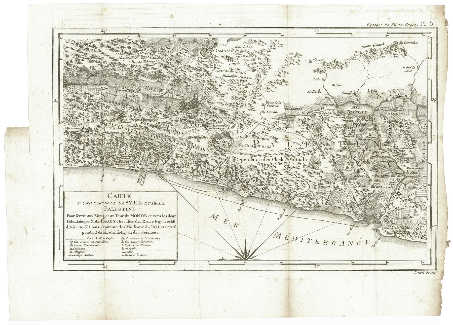
Carte d'une partie de la Syrie et de la Palestine
Pour servir aux Voyages au Tour du Monde et vers les deux Pôles, faits par M. de Pagès, Chevalier de l'Ordre Royal et Militaire de St. Louis, Capitaine des Vaisseaux du Roi, et Correspondant de l'Académie Royale des Sciences
-
Map/Doc
97121
-
Collection
General Map Collection
-
Object Dates
1782 (Creation Date)
-
Subjects
Middle East
-
Height x Width
12.8 x 17.9 inches
32.5 x 45.5 cm
-
Comments
Map appears in "Voyages Autour du Monde, et vers les deux poles par terre et par mer - Tome Second" (97086)
Related maps
Carte d'une partie de l'Amérique Séptentrionale, qui contient partie de la Nle. Espagne, et de la Louisiane

Print $20.00
- Digital $50.00
Carte d'une partie de l'Amérique Séptentrionale, qui contient partie de la Nle. Espagne, et de la Louisiane
1782
Size 14.1 x 18.5 inches
Map/Doc 94096
Voyages Autour du Monde, et vers les deux poles par terre et par mer - Tome Second

Voyages Autour du Monde, et vers les deux poles par terre et par mer - Tome Second
1782
Map/Doc 97086
Part of: General Map Collection
Edwards County Working Sketch 55

Print $20.00
- Digital $50.00
Edwards County Working Sketch 55
1951
Size 27.1 x 21.6 inches
Map/Doc 68931
Burleson County Working Sketch 44

Print $20.00
- Digital $50.00
Burleson County Working Sketch 44
1991
Size 22.4 x 25.0 inches
Map/Doc 67763
Wichita County Sketch File 24

Print $20.00
- Digital $50.00
Wichita County Sketch File 24
1919
Size 17.3 x 24.0 inches
Map/Doc 12684
Township No. 4 South Range No. 16 West of the Indian Meridian

Print $20.00
- Digital $50.00
Township No. 4 South Range No. 16 West of the Indian Meridian
1875
Size 19.4 x 24.4 inches
Map/Doc 75165
Stonewall County Working Sketch 11

Print $20.00
- Digital $50.00
Stonewall County Working Sketch 11
1950
Size 23.8 x 33.7 inches
Map/Doc 62318
Baylor County Sketch File 1a

Print $8.00
- Digital $50.00
Baylor County Sketch File 1a
1857
Size 8.2 x 7.9 inches
Map/Doc 14144
Flight Mission No. DIX-10P, Frame 173, Aransas County

Print $20.00
- Digital $50.00
Flight Mission No. DIX-10P, Frame 173, Aransas County
1956
Size 18.5 x 22.3 inches
Map/Doc 83963
Haskell County

Print $20.00
- Digital $50.00
Haskell County
1933
Size 41.7 x 36.2 inches
Map/Doc 77307
Culberson County Rolled Sketch 14

Print $20.00
- Digital $50.00
Culberson County Rolled Sketch 14
1902
Size 35.3 x 34.6 inches
Map/Doc 8743
Navarro County Sketch File 16

Print $24.00
- Digital $50.00
Navarro County Sketch File 16
1902
Size 9.7 x 6.3 inches
Map/Doc 32330
Fannin County Sketch File 9

Print $20.00
- Digital $50.00
Fannin County Sketch File 9
Size 20.7 x 16.0 inches
Map/Doc 11470
Hall County Sketch File 11

Print $12.00
- Digital $50.00
Hall County Sketch File 11
1884
Size 12.8 x 8.3 inches
Map/Doc 24808
You may also like
Jefferson County Sketch File 9

Print $40.00
- Digital $50.00
Jefferson County Sketch File 9
1860
Size 12.6 x 15.2 inches
Map/Doc 28123
Duval County Working Sketch 42

Print $20.00
- Digital $50.00
Duval County Working Sketch 42
1976
Size 24.9 x 31.1 inches
Map/Doc 68766
Aransas County Sketch File 8

Print $4.00
- Digital $50.00
Aransas County Sketch File 8
Size 11.7 x 7.9 inches
Map/Doc 13114
[Missouri, Kansas & Texas Line Map through Bastrop County]
![64032, [Missouri, Kansas & Texas Line Map through Bastrop County], General Map Collection](https://historictexasmaps.com/wmedia_w700/maps/64032.tif.jpg)
Print $40.00
- Digital $50.00
[Missouri, Kansas & Texas Line Map through Bastrop County]
1916
Size 25.4 x 106.0 inches
Map/Doc 64032
Hudspeth County Sketch File 36

Print $12.00
- Digital $50.00
Hudspeth County Sketch File 36
1901
Size 10.5 x 8.2 inches
Map/Doc 27003
Sketch Showing Original Corners and Connections Affecting Blocks T1, T2, and T3 in Lamb & Castro Counties

Print $20.00
- Digital $50.00
Sketch Showing Original Corners and Connections Affecting Blocks T1, T2, and T3 in Lamb & Castro Counties
Size 26.5 x 46.0 inches
Map/Doc 90405
A Few Things About Rice as grown along the line of the Sunset Route in Louisiana and Texas

A Few Things About Rice as grown along the line of the Sunset Route in Louisiana and Texas
1904
Map/Doc 96724
Montgomery County Working Sketch 59

Print $20.00
- Digital $50.00
Montgomery County Working Sketch 59
1962
Size 25.4 x 22.8 inches
Map/Doc 71166
Map showing the Houston & Texas Central Railroad and its connections

Print $20.00
Map showing the Houston & Texas Central Railroad and its connections
1867
Size 22.0 x 25.2 inches
Map/Doc 93604
Sherman County Boundary File 4

Print $54.00
- Digital $50.00
Sherman County Boundary File 4
Size 8.9 x 8.5 inches
Map/Doc 58782
Map of the United States

Print $20.00
- Digital $50.00
Map of the United States
1851
Size 25.1 x 25.3 inches
Map/Doc 93899
Concho County Sketch File 8

Print $44.00
- Digital $50.00
Concho County Sketch File 8
1886
Size 16.2 x 12.2 inches
Map/Doc 19131