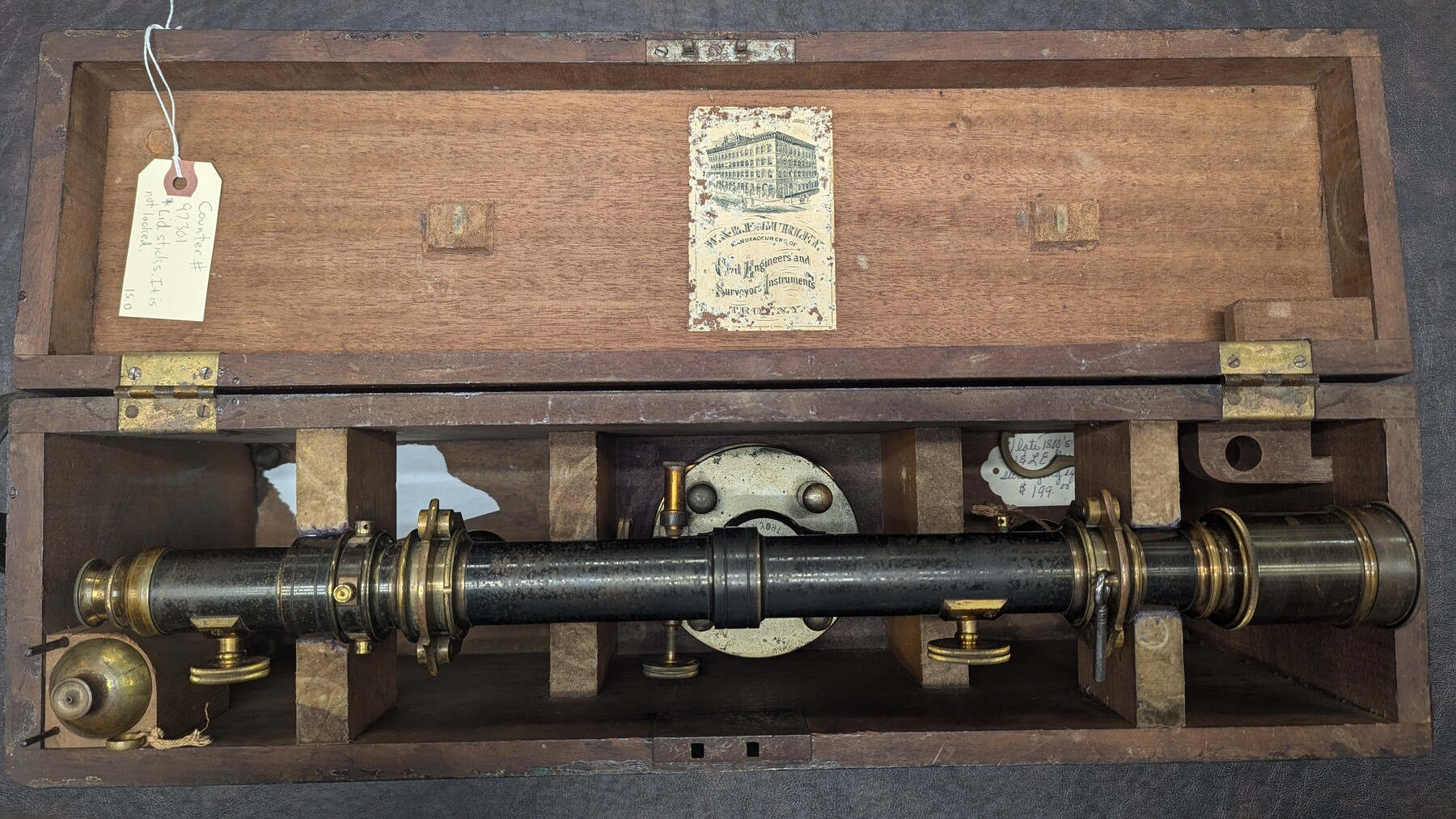
Gurley 20" Wye Level
Manufacturer: Gurley Engineering Instruments Case: Wooden Box Manufacture Location: Troy, NY
-
Map/Doc
97301
-
Collection
General Map Collection
-
Object Dates
(Creation Date)
-
Height x Width
9.5 x 22.3 inches
24.1 x 56.5 cm
Part of: General Map Collection
El Paso County Working Sketch Graphic Index - south part

Print $20.00
- Digital $50.00
El Paso County Working Sketch Graphic Index - south part
1977
Size 33.4 x 44.9 inches
Map/Doc 76537
Fort Bend County State Real Property Sketch 2

Print $40.00
- Digital $50.00
Fort Bend County State Real Property Sketch 2
1986
Size 34.8 x 43.4 inches
Map/Doc 61676
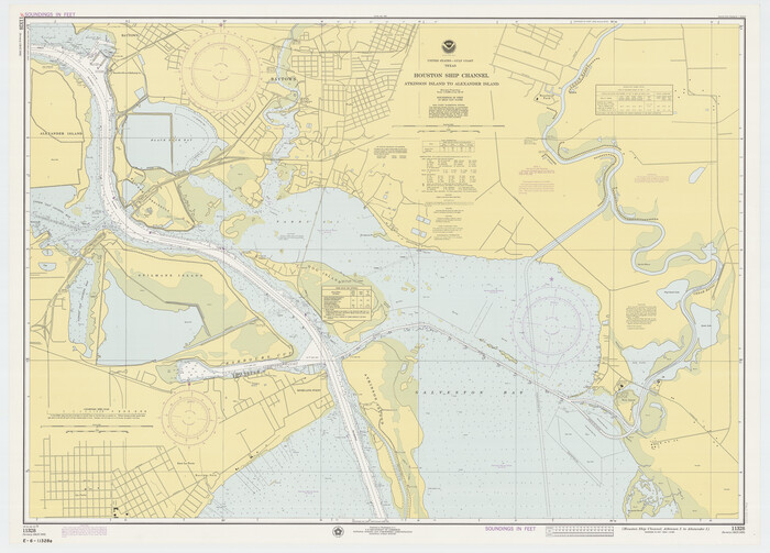
Houston Ship Channel, Atkinson Island to Alexander Island
Print $40.00
- Digital $50.00
Houston Ship Channel, Atkinson Island to Alexander Island
1975
Size 36.2 x 50.4 inches
Map/Doc 69903
Freestone County Boundary File 30

Print $8.00
- Digital $50.00
Freestone County Boundary File 30
Size 10.7 x 8.3 inches
Map/Doc 53588
Webb County Rolled Sketch 38

Print $20.00
- Digital $50.00
Webb County Rolled Sketch 38
1940
Size 22.2 x 16.0 inches
Map/Doc 8193
Brazos River, Brazos River Sheet 3

Print $6.00
- Digital $50.00
Brazos River, Brazos River Sheet 3
1926
Size 23.6 x 35.2 inches
Map/Doc 65295
Erath County Working Sketch 11

Print $20.00
- Digital $50.00
Erath County Working Sketch 11
1951
Size 45.1 x 36.2 inches
Map/Doc 69092
Hemphill County Working Sketch 37

Print $20.00
- Digital $50.00
Hemphill County Working Sketch 37
1981
Size 28.6 x 24.0 inches
Map/Doc 66132
Brazos River, Brazos River Sheet 4

Print $20.00
- Digital $50.00
Brazos River, Brazos River Sheet 4
1926
Size 19.4 x 32.1 inches
Map/Doc 69668
Zavala County Sketch File 4

Print $20.00
- Digital $50.00
Zavala County Sketch File 4
1852
Size 17.7 x 14.7 inches
Map/Doc 12726
Wise County Sketch File 2

Print $8.00
- Digital $50.00
Wise County Sketch File 2
1856
Size 8.2 x 13.4 inches
Map/Doc 40523
Moore County Working Sketch 13

Print $40.00
- Digital $50.00
Moore County Working Sketch 13
Size 38.2 x 87.5 inches
Map/Doc 71195
You may also like
Burnet County Sketch File 40

Print $4.00
- Digital $50.00
Burnet County Sketch File 40
Size 14.2 x 8.6 inches
Map/Doc 16755
Gaines County Sketch File 2M

Print $20.00
- Digital $50.00
Gaines County Sketch File 2M
1902
Size 20.8 x 29.4 inches
Map/Doc 11522
Kleberg County Rolled Sketch 10-25

Print $20.00
- Digital $50.00
Kleberg County Rolled Sketch 10-25
1952
Size 38.1 x 35.8 inches
Map/Doc 9365
Rusk County Working Sketch 10

Print $4.00
- Digital $50.00
Rusk County Working Sketch 10
Size 22.4 x 20.6 inches
Map/Doc 63645

Nueces County Rolled Sketch 68

Print $20.00
- Digital $50.00
Nueces County Rolled Sketch 68
1980
Size 19.9 x 25.4 inches
Map/Doc 6919
Hamilton County Boundary File 2

Print $4.00
- Digital $50.00
Hamilton County Boundary File 2
Size 14.2 x 8.8 inches
Map/Doc 54195
Glasscock County Sketch File 3

Print $3.00
- Digital $50.00
Glasscock County Sketch File 3
1931
Size 11.1 x 14.8 inches
Map/Doc 11560
Refugio County Boundary File 1 (3)

Print $22.00
- Digital $50.00
Refugio County Boundary File 1 (3)
Size 10.4 x 27.5 inches
Map/Doc 58231
Harris County Rolled Sketch 96B

Print $20.00
- Digital $50.00
Harris County Rolled Sketch 96B
Size 15.8 x 15.6 inches
Map/Doc 10681
Midland County Sketch File 12

Print $20.00
- Digital $50.00
Midland County Sketch File 12
1939
Size 25.4 x 18.6 inches
Map/Doc 12087
Kleberg County

Print $20.00
- Digital $50.00
Kleberg County
1913
Size 27.2 x 34.4 inches
Map/Doc 5006