Bailey County Working Sketch 6

Print $20.00
- Digital $50.00
Bailey County Working Sketch 6
1966
Size: 37.0 x 34.5 inches
67593
General Highway Map, Bailey County, Texas

Print $20.00
General Highway Map, Bailey County, Texas
1961
Size: 25.0 x 18.2 inches
79359
Sandhills Water Rights Survey, City of Lubbock, Texas

Print $40.00
- Digital $50.00
Sandhills Water Rights Survey, City of Lubbock, Texas
1957
Size: 76.1 x 31.4 inches
93211
Richland Hills Addition to Muleshoe, Bailey County, Texas

Print $20.00
- Digital $50.00
Richland Hills Addition to Muleshoe, Bailey County, Texas
1957
Size: 22.7 x 31.7 inches
92461
Richland Hills Addition to Muleshoe, Bailey County, Texas

Print $20.00
- Digital $50.00
Richland Hills Addition to Muleshoe, Bailey County, Texas
1957
Size: 22.9 x 31.8 inches
92532
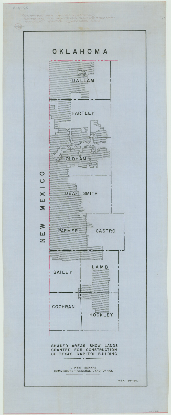
[Capitol lands granted for purpose of building State Capitol]
Print $20.00
- Digital $50.00
[Capitol lands granted for purpose of building State Capitol]
1956
Size: 31.5 x 13.0 inches
2073
Bailey County Working Sketch Graphic Index

Print $20.00
- Digital $50.00
Bailey County Working Sketch Graphic Index
1956
Size: 47.7 x 30.5 inches
76460
Plat Showing Parts of Blocks X, Y, and Z, W.D. and F. W. Johnson Subdivision

Print $20.00
- Digital $50.00
Plat Showing Parts of Blocks X, Y, and Z, W.D. and F. W. Johnson Subdivision
1955
Size: 25.7 x 16.5 inches
92501
Parkland Place, An Addition to Muleshoe

Print $20.00
- Digital $50.00
Parkland Place, An Addition to Muleshoe
1955
Size: 39.2 x 30.3 inches
92531
Plat Showing Block Z, W. D. and F. W. Johnson Subdivision, Bailey County, Texas

Print $20.00
- Digital $50.00
Plat Showing Block Z, W. D. and F. W. Johnson Subdivision, Bailey County, Texas
1955
Size: 24.3 x 15.7 inches
92538
John DePauw Lands

Print $20.00
- Digital $50.00
John DePauw Lands
1954
Size: 22.0 x 18.8 inches
92503
Plat Showing Part of Block Y, W. D. and F. W. Johnson Subdivision Number 2; and Part of Block W, Edward K. Warren Subdivision Number 1

Print $20.00
- Digital $50.00
Plat Showing Part of Block Y, W. D. and F. W. Johnson Subdivision Number 2; and Part of Block W, Edward K. Warren Subdivision Number 1
1954
Size: 23.3 x 17.4 inches
92502
League 206, Ochiltree County School Land, Bailey and Lamb Counties, Texas

Print $20.00
- Digital $50.00
League 206, Ochiltree County School Land, Bailey and Lamb Counties, Texas
1954
Size: 36.9 x 25.0 inches
92537
City Leased Property in Bailey County, Texas

Print $40.00
- Digital $50.00
City Leased Property in Bailey County, Texas
1952
Size: 65.9 x 42.7 inches
89868
Bailey County Sketch File 20

Print $40.00
- Digital $50.00
Bailey County Sketch File 20
1948
Size: 20.3 x 26.3 inches
10890
General Highway Map Bailey County, Texas

Print $20.00
- Digital $50.00
General Highway Map Bailey County, Texas
1948
Size: 18.7 x 25.8 inches
92533
Bailey County Working Sketch 5

Print $20.00
- Digital $50.00
Bailey County Working Sketch 5
1945
Size: 24.3 x 18.1 inches
67592
Bailey County Rolled Sketch 7

Print $40.00
- Digital $50.00
Bailey County Rolled Sketch 7
1941
Size: 67.1 x 43.1 inches
8931
Bailey County Sketch File 16

Print $8.00
- Digital $50.00
Bailey County Sketch File 16
1941
Size: 14.2 x 8.7 inches
13977
Bailey County Rolled Sketch 7

Print $40.00
- Digital $50.00
Bailey County Rolled Sketch 7
1941
Size: 67.7 x 44.8 inches
8438
General Highway Map, Bailey County, Texas

Print $20.00
General Highway Map, Bailey County, Texas
1940
Size: 25.1 x 18.3 inches
79010
Bailey County Working Sketch 4

Print $20.00
- Digital $50.00
Bailey County Working Sketch 4
1937
Size: 27.0 x 32.0 inches
67591
Brazos River Conservation and Reclamation District Official Boundary Line Survey

Print $20.00
- Digital $50.00
Brazos River Conservation and Reclamation District Official Boundary Line Survey
1931
Size: 25.1 x 36.9 inches
90125
Subdivision of Sutton County School League 175, Bailey County, Texas

Print $2.00
- Digital $50.00
Subdivision of Sutton County School League 175, Bailey County, Texas
1929
Size: 8.9 x 11.5 inches
90201
Subdivision of Sutton County School League 175. Bailey County, Texas

Print $2.00
- Digital $50.00
Subdivision of Sutton County School League 175. Bailey County, Texas
1929
Size: 9.1 x 11.5 inches
90278
Ochiltree County School Land League Number 204

Print $20.00
- Digital $50.00
Ochiltree County School Land League Number 204
1926
Size: 20.8 x 13.7 inches
92473
Bailey County Working Sketch 6
Print $20.00
- Digital $50.00
Bailey County Working Sketch 6
1966
-
Size
37.0 x 34.5 inches
-
Map/Doc
67593
-
Creation Date
1966
General Highway Map, Bailey County, Texas
Print $20.00
General Highway Map, Bailey County, Texas
1961
-
Size
25.0 x 18.2 inches
-
Map/Doc
79359
-
Creation Date
1961
Sandhills Water Rights Survey, City of Lubbock, Texas
Print $40.00
- Digital $50.00
Sandhills Water Rights Survey, City of Lubbock, Texas
1957
-
Size
76.1 x 31.4 inches
-
Map/Doc
93211
-
Creation Date
1957
Richland Hills Addition to Muleshoe, Bailey County, Texas
Print $20.00
- Digital $50.00
Richland Hills Addition to Muleshoe, Bailey County, Texas
1957
-
Size
22.7 x 31.7 inches
-
Map/Doc
92461
-
Creation Date
1957
Richland Hills Addition to Muleshoe, Bailey County, Texas
Print $20.00
- Digital $50.00
Richland Hills Addition to Muleshoe, Bailey County, Texas
1957
-
Size
22.9 x 31.8 inches
-
Map/Doc
92532
-
Creation Date
1957
[Capitol lands granted for purpose of building State Capitol]
Print $20.00
- Digital $50.00
[Capitol lands granted for purpose of building State Capitol]
1956
-
Size
31.5 x 13.0 inches
-
Map/Doc
2073
-
Creation Date
1956
Bailey County

Print $40.00
- Digital $50.00
Bailey County
1956
-
Size
48.5 x 31.6 inches
-
Map/Doc
1776
-
Creation Date
1956
Bailey County

Print $40.00
- Digital $50.00
Bailey County
1956
-
Size
48.8 x 31.5 inches
-
Map/Doc
73074
-
Creation Date
1956
Bailey County

Print $20.00
- Digital $50.00
Bailey County
1956
-
Size
47.0 x 30.0 inches
-
Map/Doc
77206
-
Creation Date
1956
Bailey County

Print $40.00
- Digital $50.00
Bailey County
1956
-
Size
49.4 x 31.4 inches
-
Map/Doc
95423
-
Creation Date
1956
Bailey County Working Sketch Graphic Index
Print $20.00
- Digital $50.00
Bailey County Working Sketch Graphic Index
1956
-
Size
47.7 x 30.5 inches
-
Map/Doc
76460
-
Creation Date
1956
Plat Showing Parts of Blocks X, Y, and Z, W.D. and F. W. Johnson Subdivision
Print $20.00
- Digital $50.00
Plat Showing Parts of Blocks X, Y, and Z, W.D. and F. W. Johnson Subdivision
1955
-
Size
25.7 x 16.5 inches
-
Map/Doc
92501
-
Creation Date
1955
Parkland Place, An Addition to Muleshoe
Print $20.00
- Digital $50.00
Parkland Place, An Addition to Muleshoe
1955
-
Size
39.2 x 30.3 inches
-
Map/Doc
92531
-
Creation Date
1955
Plat Showing Block Z, W. D. and F. W. Johnson Subdivision, Bailey County, Texas
Print $20.00
- Digital $50.00
Plat Showing Block Z, W. D. and F. W. Johnson Subdivision, Bailey County, Texas
1955
-
Size
24.3 x 15.7 inches
-
Map/Doc
92538
-
Creation Date
1955
John DePauw Lands
Print $20.00
- Digital $50.00
John DePauw Lands
1954
-
Size
22.0 x 18.8 inches
-
Map/Doc
92503
-
Creation Date
1954
Plat Showing Part of Block Y, W. D. and F. W. Johnson Subdivision Number 2; and Part of Block W, Edward K. Warren Subdivision Number 1
Print $20.00
- Digital $50.00
Plat Showing Part of Block Y, W. D. and F. W. Johnson Subdivision Number 2; and Part of Block W, Edward K. Warren Subdivision Number 1
1954
-
Size
23.3 x 17.4 inches
-
Map/Doc
92502
-
Creation Date
1954
League 206, Ochiltree County School Land, Bailey and Lamb Counties, Texas
Print $20.00
- Digital $50.00
League 206, Ochiltree County School Land, Bailey and Lamb Counties, Texas
1954
-
Size
36.9 x 25.0 inches
-
Map/Doc
92537
-
Creation Date
1954
City Leased Property in Bailey County, Texas
Print $40.00
- Digital $50.00
City Leased Property in Bailey County, Texas
1952
-
Size
65.9 x 42.7 inches
-
Map/Doc
89868
-
Creation Date
1952
Bailey County Sketch File 20
Print $40.00
- Digital $50.00
Bailey County Sketch File 20
1948
-
Size
20.3 x 26.3 inches
-
Map/Doc
10890
-
Creation Date
1948
General Highway Map Bailey County, Texas
Print $20.00
- Digital $50.00
General Highway Map Bailey County, Texas
1948
-
Size
18.7 x 25.8 inches
-
Map/Doc
92533
-
Creation Date
1948
Bailey County Working Sketch 5
Print $20.00
- Digital $50.00
Bailey County Working Sketch 5
1945
-
Size
24.3 x 18.1 inches
-
Map/Doc
67592
-
Creation Date
1945
Bailey County Rolled Sketch 7
Print $40.00
- Digital $50.00
Bailey County Rolled Sketch 7
1941
-
Size
67.1 x 43.1 inches
-
Map/Doc
8931
-
Creation Date
1941
Bailey County Sketch File 16
Print $8.00
- Digital $50.00
Bailey County Sketch File 16
1941
-
Size
14.2 x 8.7 inches
-
Map/Doc
13977
-
Creation Date
1941
Bailey County Rolled Sketch 7
Print $40.00
- Digital $50.00
Bailey County Rolled Sketch 7
1941
-
Size
67.7 x 44.8 inches
-
Map/Doc
8438
-
Creation Date
1941
General Highway Map, Bailey County, Texas
Print $20.00
General Highway Map, Bailey County, Texas
1940
-
Size
25.1 x 18.3 inches
-
Map/Doc
79010
-
Creation Date
1940
Bailey County Working Sketch 4
Print $20.00
- Digital $50.00
Bailey County Working Sketch 4
1937
-
Size
27.0 x 32.0 inches
-
Map/Doc
67591
-
Creation Date
1937
Brazos River Conservation and Reclamation District Official Boundary Line Survey
Print $20.00
- Digital $50.00
Brazos River Conservation and Reclamation District Official Boundary Line Survey
1931
-
Size
25.1 x 36.9 inches
-
Map/Doc
90125
-
Creation Date
1931
Subdivision of Sutton County School League 175, Bailey County, Texas
Print $2.00
- Digital $50.00
Subdivision of Sutton County School League 175, Bailey County, Texas
1929
-
Size
8.9 x 11.5 inches
-
Map/Doc
90201
-
Creation Date
1929
Subdivision of Sutton County School League 175. Bailey County, Texas
Print $2.00
- Digital $50.00
Subdivision of Sutton County School League 175. Bailey County, Texas
1929
-
Size
9.1 x 11.5 inches
-
Map/Doc
90278
-
Creation Date
1929
Ochiltree County School Land League Number 204
Print $20.00
- Digital $50.00
Ochiltree County School Land League Number 204
1926
-
Size
20.8 x 13.7 inches
-
Map/Doc
92473
-
Creation Date
1926